

Akrotiri, Santorini, Cyclades,South Aegean
Kasteli of Akrotiri
or La Ponta


| Location: |
| Akrotiri, Santorini Island |
| Region > Prefecture: |  |
| South Aegean Cyclades | |
| Municipality > Town: | |
| City of Santorini • Akrotiri | |
| Altitude: | |
| Elevation ≈ 80 m |
| Time of Construction | Origin | |
| 14th century | VENETIAN |
|
| Castle Type | Condition | |
| Island Citadel |
Average
|
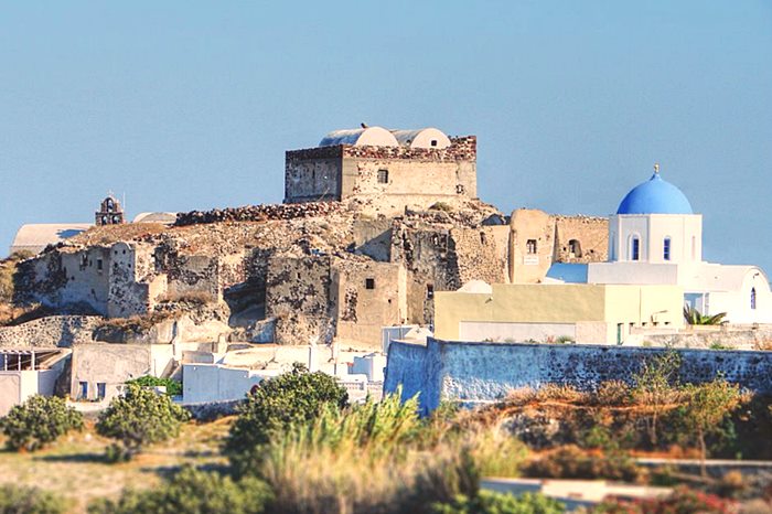
It was built around 1335 and used to be called ‘Punta Castelli’ and ‘La Ponta’, which in medieval Italian meant ‘the peak’. It was donated by Nikolas Sanudos, Duke of Naxos, to the Gozadini family, who kept the gulas under their power until 1617 even though the Turks had already invaded the rest of the island. At the center of the settlement is situated a Goulas (tower) which was in good condition until the earthquake of 1956. There is also a second gulas at the Castelli of Akrotiri, a bit farther from the center of the settlement.
The tower today is private owned. Between the years 2012 and 2017 housed an exhibition of musical isntruments which today is closed. .
| First entry in Kastrologos: | November 2012 |
|
|
| Access |
|---|
| Approach to the monument: |
| - |
| Entrance: |
| Free access to the perimeter |
| Other castles around |
|---|
| Kasteli of Emporeio |
| Goulas of Emporio |
| Kasteli of Pyrgos |
| Citadel of Oia |
| Castle of Skaros |