

Amfissa, Delphi, Phocis,Central Greece
Castle of Amfissa
or Salona Castle
1
2 / 47

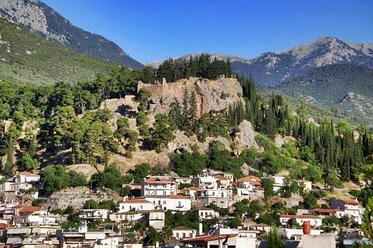
A closer look to the caste
3 / 47

The entrance to the castle of Amfissa
4 / 47

SW bastion (3) built with polygonal ancient stones (WW II guardpost at the top)
5 / 47

ancient wall between the NW bastion (3) and the tower (2)
6 / 47

Tower (2) of the SW side, before the gate (aka Frankish church)
7 / 47

Tower (2) of the SW side, (aka Frankish church)from the inside
8 / 47

Tower (2) of the SW side, (aka Frankish church)from the inside
9 / 47

Ramp (9) to NW bastion of the lower level
10 / 47

Ramp (9) to NW bastion of the lower level
11 / 47

NW bastion (6) of the lower level
12 / 47

NW wall of the lower level (here was probably a sealed gate)
13 / 47

NW wall and the internal wall (behing the round tower and the palace
14 / 47

West part of the internal wall (up to 3m thick)
15 / 47

Towards the gate of the upper level (keep)
16 / 47

Gate of the upper level (keep)
17 / 47

Above the gate of the keep
18 / 47

19 / 47

The upper level
20 / 47

Part of the internal wall (with a secret opening)
21 / 47

Interna wall
22 / 47

Interna wall
23 / 47

Interna wall
24 / 47

Cistern 13 at the upper level
25 / 47

Cistern (13) with two spaces used in WW II as amunition storage
26 / 47

Central building or “Palace” (12) at the upper level
27 / 47

Central building or “Palace” (12) at the upper level
28 / 47

Palace (12) and cistern (13)
29 / 47

Palace (12) and cistern (13)
30 / 47

Cistern (14)
31 / 47

Round tower (10) of the upper level
32 / 47

Round tower (10) of the upper level
33 / 47

Round tower (10) of the upper level
34 / 47

Round tower (10) of the upper level
35 / 47

North bastion of the keep with WW II gunpost
36 / 47

North bastion of the keep with WW II gunpost
37 / 47

North bastion (secret entrance visible)
38 / 47

Ruins of round tower (11) between two gunposts
39 / 47

Parts of wast wall of the keep
40 / 47

East part of internal wall nad SW bastion (5)
41 / 47

Soouth walls
42 / 47

South bastion (4)
43 / 47

Square tower @) 1906 (2)
44 / 47

upper level, 1909
45 / 47

Edward Dodwell, 1819
46 / 47

47 / 47


THE END
| Location: |
| Amfissa, near Delphi, Central Greece |
| Region > Prefecture: |  |
| Central Greece Phocis | |
| Municipality > Town: | |
| City of Delphi • Amfissa | |
| Altitude: | |
|
Elevation ≈ 290 m (Relative Height≈125 m) |
| Time of Construction | Origin | |
| In various periods | FRANKISH |
|
| Castle Type | Condition | |
| Castle |
Not Good
|
The castle of Amfissa, also known as castle of Salona or castle of Oria, is situated on a rocky hill at 290m altitude above the city of Amfissa in Central Greece, close to Delphi.
It is built at the location of the ancient acropolis. What we see today from the castle are the remains of the castle built by the Franks in the 13th century, but there are also many elements from the Byzantine and the Ancient Greek period.
History
The castle has a rich history which starts from the Pelasgians and the classical antiquity and reaches the years of the Greek Revolution. It was attacked, besieged, destroyed and repaired many times by Macedonians, Gauls, Visigoths, Huns, Bulgarians, Slavs, Franks, Catalans, Turks and others.
Amfissa was important in the classical period for a good reason: it was the closest city-state to Delphi which those days was the center of the world (for the Greeks, it was). It also had the advantage of a strong fortification. Parts of the walls of the ancient acropolis of the town date back between the 7th and the 6th century BC.
The most notable event in the ancient period was the complete destruction of the city and the acropolis by Philip II of Macedonia in 338 BC, for reasons that had to do with the people of Amfissa trying to mess with the Oracle of Delphi and its treasures.
The Amfissians managed to rebuild their town and later became a powerful member of the Aetolian League. When the Romans occupied the rest of Greece, Amfissa repelled their attacks and finally was allowed not to pay taxes to Rome.
In the early Middle Ages, Amfissa was devastated by several foreign peoples who invaded Greece. In 396 was destroyed by the Alarric’ Visigoths and in 448 by the Huns of Attila.
Since the middle of the 10th century, new invaders, the Bulgars, raided the region of Phocis and sieged Amfissa several times, but the most damaging was in 996, when Samuel of Bulgaria destroyed the town and slaughtered its people. in 1065, Ouzoi besieged Amfissa one more time and forced the Amfissians to hide in caves of the region to avoid a massacre.
In 1205, after the Fourth Crusade and the establishment of the Latin Empire, Boniface of Montferrat, the Frank king of Thessaloniki, conquered the region of Central Greece. Amfissa became the seat of a barony under Thomas I d'Autremencourt. It is then that the new governors built the powerful Castle of Salona on the hill where the ancient acropolis existed, while the ancient name of the town was replaced by the new name Salona, or La Sole in French and La Sola in Italian.
The Franks remained the lords of Amfissa until 1311. Then, in the battle of Cheronia, the Catalans defeated the Franks and conquered Central Greece including the Ducy of Athens and, together with other regions, Salona.
The Catalan occupation lasted until 1394. The most notable rulers of this era were Alfonso Federico de Sicilia, a powerful man who was the Vicar (and actual ruler) of the Duchy of Athens from 1318 until 1330, and his grandson Lluís Frederic d'Aragó. The latter reigned between 1362 and 1382 and was popular among his Greek subjects. After his death in 1382, his widow, the Byzantine princess Helen Frederic-Kantakouzene ruled until 1394.
The widow was an efficient governor, but, at the end, she fell in love with a corrupt priest, Papa-Stratos, who gathered too much power. His actions provoked the Greek population, and the Orthodox bishop Serafeim called the Ottoman for help.
The sultan Bayezid I captured Amfissa in 1394. In 1402 the castle and the city passed under the control of the Despotate of Mystras. The Byzantines were not able to hold it in those difficult years and sold it to the knights of the Order of St.John (of Rhodes).
The Turks returned in 1410, captured the castle again, and this time stayed for a few centuries, with a short break of independence under Venetian control from 1687 to 1698.
In the 18th century, Salona became the center of preparations for the war against the Ottoman Turks in Central Greece, due to its strategic location and its proximity to the klephts of Giona and Parnassus mountains.
In the Greek War of Independence, Salona was the first town of Central Greece to revolt. On March 27, 1821, the warlord Panourgias invaded the town and on April 10 the Greeks captured the Castle of Salona, the first fortress which fell in Greek hands, and killed the 600 of the Ottoman garrison.
The Turks recaptured briefly the castle in 1825 and again in 1826; they stayed until 1829.
Structure, Fortification & Buildings
The castle is located on a pine-covered hill on the northwest side of the town of Amfissa. It occupies an area of 18,000 sq.m. within a fortified enclosure with an irregular layout, which largely follows the terrain's relief. The outer perimeter of the enclosure is approximately 570 meters.
In the castle, various building phases co-exist starting from Classical Antiquity and reaching up to the Turkish occupation.
The castle is divided into two sections: the lower castle or lower plateau and the upper castle or upper plateau or the citadel.
The two plateaus have a small height difference, 2-3 meters, and are separated by an internal transverse wall (photos 20-23)
Lower Enclosure
The lower castle has an almost triangular shape, an area of 15,500 sq.m. and a perimeter of 460 m. It has four bastion-towers (see LAYOUT). It is accessible from two points: from the western gate which is also the main gate of the castle (photo 3) and from a passage on the NE side that connects the castle with the modern city.
There are no buildings inside the lower castle.
The main gate of the castle is placed in such a way that to approach it one has to walk parallel to the wall exposed to the defenders for 60 meters.
On this side of the castle of Amfissa the different building phases can be better observed . Here is the south-west bastion (photo 4, point 3 on LAYOUT), the first part of the castle that we encounter before the entrance, built of ancient polygonal stones in second use, with medieval masonry above and a WWII machine gunpost on top.
One of the best preserved parts of the ancient phase is a 32 m long wall after the SW tower, built according to the trapezoidal building system (photo 5). After this wall, it continues with a section of ancient masonry in the lower part at a height of 7 stone-blocks and a medieval construction above (photo 6).
At this point, near the gate, a large rectangular tower 12.5 meters high is preserved (photo 6,7,8,43). This rectangular tower, also known locally as the “Frankish church”, is one of the most characteristic points of the castle, and in the past, when there were no pine trees, it dominated the hill.
As for the rest of the walls of the lower enclosure, the west and north-west sides, north of the entrance, generally have straight walls and have medieval masonry (photos 9,12). It ends in the northwest in a bastion (photo 11, point 6 on the LAYOUT) which is accessed by a stone-paved ramp (photos 9,10), which was probably added during the Turkish period.
On the eastern side of the lower enclosure, east of the SW bastion, the height of the walls rarely exceeds the height of the ground inside. The height reaches 10m externally, but it seems to function more as a retaining wall. Many parts of the wall are damaged on this side, due to landslides.
Upper Castle or the Citadel
The upper castle, with a perimeter of 250m (incl. the internal transverse wall) in a long and narrow layout (length 115m, width up to 40 m), with an area of around 2,500 sq.m., is located on the northeastern steep part of the hill. Here was the citadel of the castle and probably the administrative center and the lord’s residence.
As mentioned, the upper level is separated from the lower one by a transverse internal wall. The remaining -external- sides of the citadel have strong walls in the northwest and southeast, while the rest of the walls are not so strong, because they are based on the steep rock that provides natural protection.
In the upper castle there are ruins of two square and two round towers as well as ruins of various other buildings. There are also two cisterns.
One of the most characteristic buildings on the citadel is an elongated building also described as a “palace” (photos 26-29) which was probably the residence of the Count of Salona.
The entrance to the citadel is from the lower yard through a small gate (photos 16-18) on the eastern side of the transverse wall, while on the western side there is a second much smaller opening described in the literature as the “secret passage” (photo 20). The eastern gate is built with large boulders and is believed to have remained the same since ancient times.
On the western side of the citadel dominates the half-demolished round tower which was apparently a watchtower (photos 31-34, point 10 on the LAYOUT). Its masonry consists of mudstone construction with binding mortar and is reinforced at its base with a massive buttress.
Another ruined tower, at a low height, is between two machine gunposts of the WW II on the northwest side of the citadel (photo 38, point 11 in the LAYOUT).
On the north side of the citadel is an interesting two-story building with elaborate construction, based on an ancient tower (photo 35-37). It is described as a bastion but its use and its dating are unclear. A machine gunpost has been built on top of it.
Ancient Walls
In addition to the fortification of the castle on the hill, in Amfissa parts of the ancient wall are also preserved. The strong walls of the city started from the castle in two branches and surrounded the city. The area within the walls was approximately 305,000 sq.m., while the perimeter of the walls was perhaps 2.5 kilometers.
Important sections of the ancient fortification wall have been uncovered in rescue excavations in different parts of the town
Some parts are kept visible and can be visited. Some of them are in basements and some are integrated into newer homes.
| First entry in Kastrologos: | October 2012 | Last update of info and text: | May 2023 | Last addition of photo/video: | May 2023 |
Sources
- Yorgos Costopoulos, research and photos 3-42, 47 (November 2022)
- Καραβέντζας Θωμάς, Δάσκαλος, ιστοσελίδα ΚΠΕ Άμφισσας - TO KΑΣΤΡΟ ΤΗΣ ΩΡΙΑΣ ΤΩΝ ΣΑΛΩΝΩΝ
- Antoine Bon, 1937. Forteresses médiévales de la Grèce centrale, Bulletin de Correspondance Hellénique 61, 164-186.
- Ιωάννης Θ. Σφηκόπουλος, Μεσαιωνικά κάστρα και πύργοι στη Ρούµελη, Αθήναι, 1981.
- Website 2steps.gr - Κάστρο Άμφισσας, Φωκίδα (Greek only)
- Μαρία-Φωτεινή Παπακωνσταντίνου, ΤΟ ΚΑΣΤΡΟ ΤΗΣ ΑΜΦΙΣΣΑΣ ΚΑΙ Η ΠΡΟΟΠΤΙΚΗ ΑΝΑ∆ΕΙΞΗΣ ΤΟΥ, Πρακτικά Επιστημονικού Συνεδρίου «Το κάστρο των Σαλώνων (Άμφισσας)-Ιστορική Διαδρομή-Δυνατότητες και Προοπτοκές Ανάπτυξης», Άμφισσα 2014, σελ.19-32
- Γιώργος Πάλλης, ΤΟ ΚΑΣΤΡΟ ΤΗΣ ΑΜΦΙΣΣΑΣ ΚΑΙ Η ΟΧΥΡΩΜΑΤΙΚΗ ∆ΡΑΣΤΗΡΙΟΤΗΤΑ ΣΤΗΝ ΑΝΑΤΟΛΙΚΗ ΣΤΕΡΕΑ ΕΛΛΑ∆Α ΚΑΤΑ ΤΗ ΦΡΑΓΚΟΚΡΑΤΙΑ, Πρακτικά Επιστημονικού Συνεδρίου «Το κάστρο των Σαλώνων (Άμφισσας)-Ιστορική Διαδρομή-Δυνατότητες και Προοπτοκές Ανάπτυξης», Άμφισσα 2014, σελ.65-73
- Ανθούλα Τσαρούχα, Η ΑΡΧΑΙΑ ΑΜΦΙΣΣΑ ΚΑΙ Η ΟΧΥΡΩΣΗ ΤΗΣ, Πρακτικά Επιστημονικού Συνεδρίου «Το κάστρο των Σαλώνων (Άμφισσας)-Ιστορική Διαδρομή-Δυνατότητες και Προοπτοκές Ανάπτυξης», Άμφισσα 2014, σελ.36-45
- Ουΐλλιαμ Μίλλερ, 1909, Ιστορία της Φραγκοκρατίας εν Ελλάδι (1204-1566), μετάφρ. Σπυρ. Π. Λάμπρου, μετά προσθηκών και βελτιώσεων, Εν Αθήναις Ελληνική Εκδοτική Εταιρεία, 1909-1910, τόμος Β’, σελ.21-24
- Σπύρος Λάμπρου, Ο τελευταίος κόμης των Σαλώνων, Εν Αθήναις 1870 (θεατρικό δράμα)
- Ρουβιό υ Λιούκ Α., 1912. Περί των καταλανικών φρουρίων της ηπειρωτικής Ελλάδος (µτφρ. Μαυράκη Γ.Ν.), εν Αθήναις
- Βικιθήκη - Χρονικό του Γαλαξειδίου, Διά χειρός Ευθυμίου ιερομονάχου, 1703 (Μετά προλεγομένων και άλλων ιστορικών σημειώσεων Κωνσταντίνου Ν. Σάθα)
- Λαόνικος Χαλκοκονδύλης - Αποδείξεις Ιστοριών Α’
|
|
| Access |
|---|
| Approach to the monument: |
| By car or walking from the town of Amfissa, via Fanariou street. |
| Entrance: |
| The entrance is free. To castle is not organised and is more like an urban parc. |
| Timeline |
|---|
|
| Other castles around |
|---|
| Tower of Amfikleia |
| Castle of Kastellia |
| Tower of Kirra |
| Tower of Lilaia |
| Tower of Madamia |
| Tower of Tolofon |
| Castle of Velouchovo |