

Argos, Argos-Mycenae, Argolis,Peloponnese
Castle of Argos
or Larisa Castle
1
2 / 28

General view from the east
3 / 28

photo by Fred Kok (July 2023)
4 / 28

The entrance to the castle
5 / 28

photo by Fred Kok (July 2023)
6 / 28

Castle interior immediately after the entry
7 / 28

Exterior wall detail with ancient column
8 / 28

View to the city of Argos from a bastion
9 / 28

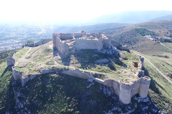
Aerial view from the SΕ (G.Traveller 2018)
10 / 28

photo by Fred Kok (July 2023)
11 / 28

View of the inner castle
12 / 28

View of the inner castle
13 / 28

View from the keep tower to Argos
14 / 28

The northern walls of the keep tower
15 / 28

photo by Fred Kok (July 2023)
16 / 28

Drawing by W. Lindon 1856
17 / 28

Towers of Larisa-Engraving 1810, William Gell
18 / 28

General view
19 / 28

Aerial view
20 / 28

Aerial view (G.Traveller 2018)
21 / 28

Aerial view
22 / 28

1998 stamp of the Greek Post Office
23 / 28

photo by Jennifer Jones (2016)
24 / 28

photo by Jennifer Jones (2016)
25 / 28

photo by Jennifer Jones (2016)
26 / 28

photo by Fred Kok (July 2023)
27 / 28

December 2016
28 / 28

aerial view 1960 (sent by Leonidas Nasopoulos)

THE END
| Location: |
| On a hill above the town of Argos, Peloponnese |
| Region > Prefecture: |  |
| Peloponnese Argolis | |
| Municipality > Town: | |
| City of Argos-Mycenae • Argos | |
| Altitude: | |
|
Elevation ≈ 289 m (Relative Height≈289 m) |
| Time of Construction | Origin | |
| 10th century | BYZANTINE |
|
| Castle Type | Condition | |
| Castle |
Average
|
One of the ancient castles of Greece. The location was fortified since prehistoric times and remained a powerful fortress through the classical period and the Middle Ages until the 19th century.
Location & Strategic Scope
At the northern side of the town of Argos, there are two hills To the NE is Aspis and to the NW Larissa, the tallest of the two (289m). In the antiquity, there was another castle on Aspis which did not survive. There was a wall between the two castles for the protection of the city from the north.
The Name of the Castle
The first inhabitants of the area were the Pelasgians and the names "Argos" and "Larissa" are pelasgian. The meaning of the first was valley and of the latter acropolis.
History
Τhe castle was created in the 6th century B.C. but there was a fortification there since prehistoric times and the epoch of the Pelasgians. The medieval castle was first built by the Byzantines in the 10th century.
During the Byzantine period, the fortress was of essential strategic importance. In 1203, it came under the control of the archon of Nauplion, Leon Sgouros. In 1212 it was captured by Othon de la Roche, the Bourgoundian Duke of Athens, and was controlled by the Franks until 1388.
Between 1394 and 1463 it was occupied by the Venetians. In 1463 it was captured by the Turks and remained under their control until 1822, interrupted during 1686-1715, when Larissa came under the control of the Venetian admiral Morozini. The site was liberated by the Greeks in 1822.
| First entry in Kastrologos: | April 2012 | Last addition of photo/video: | July 2023 |
Sources
- Pictures 23 to 25 s by Jennifer Jones, site Picturesque Peloponnese
- Photos 3, 5, 10, 15, 25 by Fred Kok (July 2023)
- Video by the user
G Traveller Το Φράγκικο κάστρο στο Άργος | Κάστρο Λάρισα (Άργος) | Castle Larisa (Argos) (source also of the pics 1, 9, 20)
|
|
| Access |
|---|
| Approach to the monument: |
| The hill of the castle is about 2 km from the city of Argos. The road is paved and there is a spacious parking lot close to the entrance. |
| Entrance: |
| The entrance is free but is allowed only in the morning. |
| Timeline |
|---|
|