

Arla, Dytiki Achaea, Achaea,West Greece
Gyftokastro
or Castle of Arla or Castle of Fostena
1
2 / 18

photo by Π.Βασιλτσιωτελλης, Apr 2021
3 / 18

the west side of the caste
4 / 18

the east side of the caste
5 / 18

view from the south
6 / 18

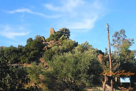
photo by Kostas Gertzos, Jan 2020
7 / 18

photo by Kostas Gertzos, Jan 2020
8 / 18

photo by Kostas Gertzos, Jan 2020
9 / 18

photo by Kostas Gertzos, Jan 2020
10 / 18

photo by Kostas Gertzos, Jan 2020
11 / 18

photo by Kostas Gertzos, Jan 2020
12 / 18

photo by Π.Βασιλτσιωτελλης, Apr 2021
13 / 18

photo by Π.Βασιλτσιωτελλης, Apr 2021
14 / 18

photo by Π.Βασιλτσιωτελλης, Apr 2021
15 / 18

photo by Π.Βασιλτσιωτελλης, Apr 2021
16 / 18

photo by Π.Βασιλτσιωτελλης, Apr 2021
17 / 18

photo by Π.Βασιλτσιωτελλης, Apr 2021
18 / 18

photo by Π.Βασιλτσιωτελλης, Apr 2021

THE END
| Location: |
| Southeast of Arla village, Achaea, Peloponnese |
| Region > Prefecture: |  |
| West Greece Achaea | |
| Municipality > Town: | |
| City of Dytiki Achaea • Arla | |
| Altitude: | |
|
Elevation ≈ 100 m (Relative Height≈20 m) |
| Time of Construction | Origin | |
| 13th century | FRANKISH |
|
| Castle Type | Condition | |
| Castle |
Not Good
|
A castle which is connected with the origin of two villages: Fostena and Arla. Administratively, it belongs to another village: Flokas.
It is on top of a low hill on the road leading to Santomeri. It is one of the relatively well preserved castles in Achaea.
The Name of the Castle
It has not been securely identified. Some scholars identify it with Phostena and others with Arroula which may have become Arla, although the latter was never a medieval village.
“Gyftokastro” means Gypsy castle. The name is most likely related to a gypsy population that may have occupied the site in the nineteenth century. Sometimes it is also called “Egyptiokastro” which led some scholars to relate it with Egyptian population. But “Egyptiokastro” is probably a beautification of the unflattering “Gyftokastro”.
History
Regardless of the identification of the original name, the region in the beginning of Frangokratia belonged to the barony of Chalandritsa. The first baron was the celebrated Guy de Dramelay or Gui de la Trémoille or Tremoulas (for the Greeks).
The castle, most probably, was built during his rule, in the first decades of the 13th century.
Structure, Fortification & Buildings
The fortress is a contiguous building of irregular polygonal plan with towers, embrasures and a gate.
It measures ca. 50m✖30m and survives to almost complete elevation with collapse most severe on the east side where large holes in the wall are visible.
The masonry is of small, uncut stones, mortar and tiles, with ca. 2 m wall thickness. Surface rooftiles and pottery, including Frankish cooking ware, date occupation to the medieval period. Α cistern roofed with pointed vault, ca. 10m✖7m, is located in the middle of the fortress.
A nearby stream offers ample supply of water. An early modem water mill is situated immediately below the fortress.
| First entry in Kastrologos: | October 2012 | Last update of info and text: | May 2021 | Last addition of photo/video: | May 2021 |
Sources
- Konstantinos Kourelis, “MONUMENTS OF RURAL ARCHAEOLOGY MEDIEVAL SETTLEMENTS ΙΝ ΤΗΕ NORTHWESTERN PELOPONNESE”, Presented to the Faculties of the University of Pennsylvania in Partial Fulfillment of the Requirements for the Degree of Doctor of Philosophy, 2003, page 248
- Photos (1 and 6–12) Kostas Gertzos, January 2020
- Video by the user Kostas Gertzos ΑΙΓΥΠΤΟΚΑΣΤΡΟ ΑΧΑΪΑΣ (DRONE). AIGYPTOKASTRO CASTLE AERAL VIEW, ACHAEA, GREECE
- Photos (2 and 13–18) Παναγιωτης Βασιλτσιωτελλης, April 2021
|
|
| Access |
|---|
| Approach to the monument: |
| From Patra take E55 to SW. Turn left to the Industrial zone and continue to Soudaneika and Arla. Distance 35km. The castle is on la ow hill on the road 1km after Arla. |
| Entrance: |
| Free access |


