

Ebonas, Rhodes, Dodecanese,South Aegean
Castle of Ebonas
or Castle of Kitala


| Location: |
| North of the village Ebonas in Rhodes, on the hill Kitala |
| Region > Prefecture: |  |
| South Aegean Dodecanese | |
| Municipality > Town: | |
| City of Rhodes • Ebonas | |
| Altitude: | |
|
Elevation ≈ 475 m (Relative Height≈70 m) |
| Time of Construction | Origin | |
| before 14th century | Late-BYZANTINE |
|
| Castle Type | Condition | |
| Castle Ruins |
In Ruins
|
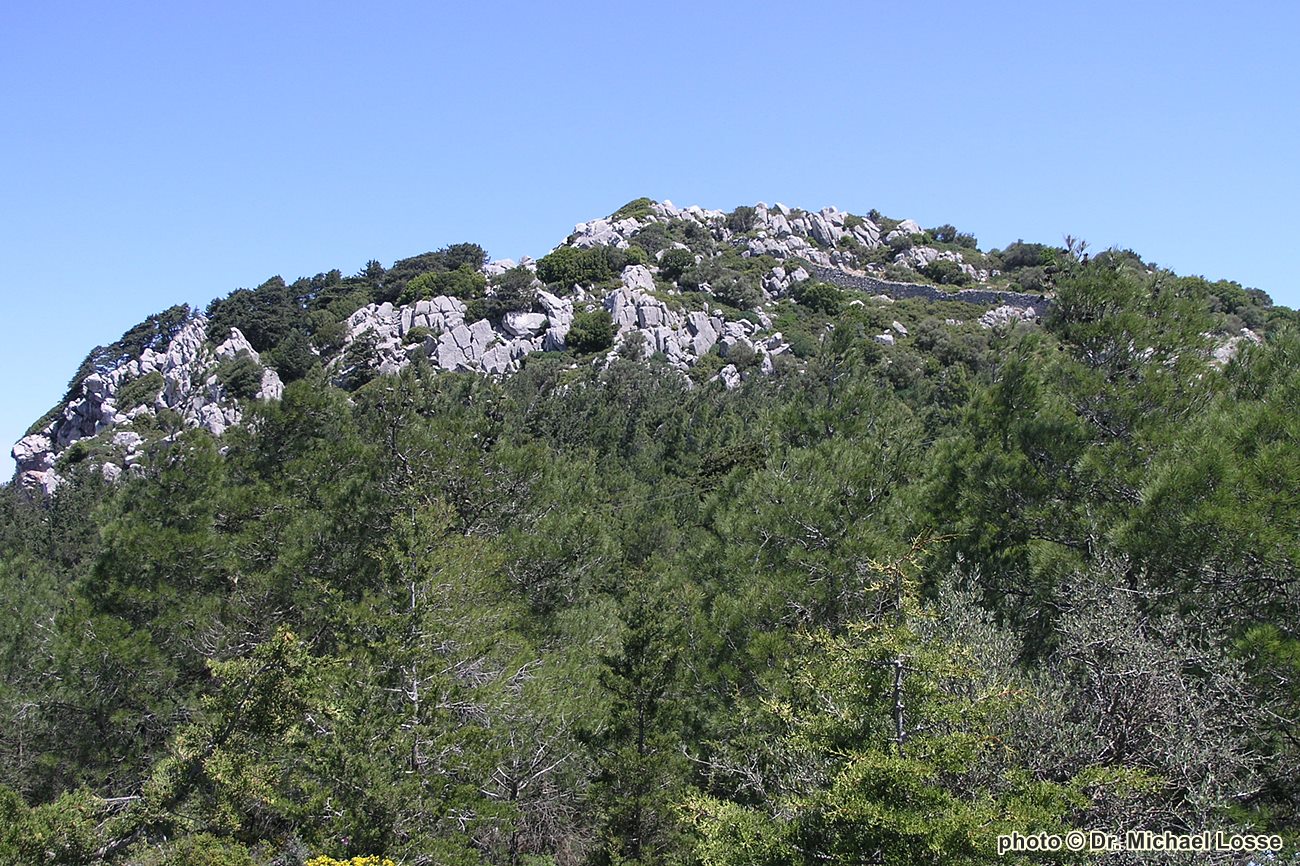
Remains of an isolated fortified position-settlement 4km north of Ebonas.
It was a Byzantine castle, most probably used (and strengthened) by the Order of the Knights of St John (Hospitaller Knights).
Castle Description
Text: Dr. Michael Losse – Singen (Hohentwiel), Germany (17.11.2021)General Description
A good 4 km northeast of Embonas rises, isolated from Mt. Atavyros, the limestone mountain Kitala with remains of a fortification called Kastro, which was mentioned in the literature under Embonas (cf. Gerola 1914, p. 331).
Michael Heslop (2009, p. 73) speculated that Kitala was the predecessor settlement of Embona.
19th century archeologists and explorers who knew Kitala were Prof. Ludwig Ross (1845) and Charles Thomas Newton (1865 [1989], p. 206). In the 20th century there were references by Giuseppe Gerola, Inglieri (Carta Archeologica dell'Isola di Rodi. Florence 1935-36, p. 47), Kara Hattersley-Smith (1994, pp. 86-87) and Michael Heslop (2009, especially pp. 72-73).
Prof. Ross (1845, p. 108) described the castle: "Five quarters of an hour north of Embonas, along the path that [...] leads directly to Rhodes, lies a rocky hill, Kitala [...], around whose steep and narrow rocky peaks a wall of six feet thick, poorly built of quarry stones in mortar, but perhaps Hellenic, stretches. [...] On the ridge east under this Kastron are in several places Hellenic cuboids; in particular, at one point there are three or four small square bases with tap holes for receiving consecration gifts. According to the tradition of the peasants, there would have been a magnificent church (or a temple?) here, but was blown up by the Turks through a mine." (German original text: „Fünf Viertelstunden nördlich von Embonas, an dem Wege, der über […] direct nach Rhodos führt, liegt ein felsiger Hügel, Kitala […] genannt, um dessen steilen und schmalen Felsgipfel sich eine aus Bruchsteinen in Mörtel schlecht gebaute, doch vielleicht hellenische Mauer von sechs Fuß Dicke zieht. [...] Auf dem Hügelrücken östlich unter diesem Kastron sind an mehreren Stellen hellenische Quadern; namentlich liegen an einer Stelle drei oder vier kleine quadrate Basen mit Zapflöchern zur Aufnahme von Weihgeschenken. Nach der Ueberlieferung der Bauern wäre hier eine prächtige Kirche (oder ein Tempel?) gewesen, aber von den Türken durch eine Mine in die Luft gesprengt worden.“
The nowadays heavy vegetation (trees, bushes, macchia) prevents an overview of the overall structure of the apparently multi-phase fortification. On the mountain’s southwestern side, under the vegetation, some wall features are visible, which cannot be clearly named as parts of the Kástro or later arable terraces.
The defensive wall seems not surround the whole summit closed (cf. the similar situation of the Byzantine castle next to Moní Inko on Rhodes and Kokkinokastro, Island of Symi [cf. article in Kastrologos]). Remains of brickings of individual crevices can be seen from the foot of the mountain.
The wall runs along the steeper north and east sides with the inclusion of several upright rocks with interruptions, while on the west and southwest sides it encloses a part of the less steep slope terrain here. It is built as a two-shell wall in mortar setting made of limestone quarry stone and reaches a thickness of up to 1.90 m in the area of the accessible sections. The wall still reaches a height of over 4 m at the highest points. Flat, flat limestones and occasionally larger limestone quarry stones characterize the wall’s outer shell.
The access was probably from the southwest side; here is a tangential gate with a beam bar hole. In a later construction phase (in the late Middle Ages?) a two-thirds round building (maybe a tower, Ø about 6 m) was submitted to this, but it is not possible to judge from the above-ground visible stock whether the gate path was added with it. The collapse heap in the gate area is likely to consist of material from the tower.
To secure the gate or gate path, a rectangular defensive structure served flanking the gate (cf. the castles Monolithos and Siana), which is recognizable as a later extension by a structural joint existing to the defensive wall. During the 2nd World War it apparently was used as a machine-gun post.
The interior of the Kastro was not leveled, here rise several steep rocks. Of the possible buildings within the castle, no visible remains remained. A deep crevice visible under bushes was used as a cistern. In the Kástro there are few pottery shards and brick fragments.
The Kastro Kitala offers visual contact to various fortifications on the island of Rhodes (including for exmple Kastelas at Kamiros Skala; Erimokastro near Arnitha; the Byzantine castle next to Moni Inko) as well as to castles on the islands of Halki and Alimia and to the islands of Tilos and Symi.
Access
The ascent to the castle hill is cumbersome, there is no path, the hill flanks are densely overgrown. Under the vegetation, cisterns and crevices open up in the slope! There are plenty of snakes in the field!
Free access.
History of the castle
The mountain Kitala (504 m) is an isolated ridge-like, strongly indented limestone peak between the mountains Atavyros and Profitis Ilias. A pass road has certainly passed here since early times. This and the possibility of a view between Mt. Atavyros and Mt. Profitis Ilias probably required a military use of the mountain at an early stage.
Early scholars mentioned Kitala as an ancient fortification, for example Prof. Ross (1845, p. 108: "Kitala [...], around whose steep and narrow rocky peaks a wall of six feet thick, poorly built of quarry stones in mortar, but perhaps Hellenic, stretches“) and Gerola (1914: "Kjítala [...] antico fortilizio"). However, the preserved castle ruins were most likely a Byzantine fortification.
Gerola (1914) equated “Kjítala” with the “casale [...] di Quitalia”, mentioned by the Knights Hospitallers‘ chronicler Giacomo Bosio (edition 1695): With a decree of 1474 it was stipulated that the inhabitants of the villages of Kitala and Kapi should go to the Kastro Kitala, which formed a protaria, in case of danger. Further historical facts are not known.
It is obvious to assess the Kastro as a Byzantine fortification (possibly in the place of an ancient predecessor) which was apparently used by the Knights Hospitalers as a refuge for the surrounding population and therefore strengthened in the gate area, perhaps in the context of the arrangement of 1474.
Nothing could be learned about the demolition of the castle by Turks mentioned by Prof. Ross (1845, p. 108).
Other Info
SourcesGerola, Giuseppe: I monumenti medioevali delle 13 Sporadi. In: Annuario della Scuola Archeologica di Atene e delle Missioni Italiane in Oriente, Vol. I, 1914, pp. 319-356, and Vol. II, 1916, pp. 29-54.
Hattersley-Smith, Kara: Documentary and Archeological Evidence for Greek Settlement in the Countryside of Rhodes in the Fourteenth and Early Fifteenth Centuries. In: Malcolm Barber (Ed.): The Military Orders: Fighting for the Faith and Caring for the Sick. Aldershot 1994, pp. 82-88.
Heslop, Michael: The Search for the Byzantine Defensive System in Southern Rhodes. In: Βυζαντίνος Δόμος 16 (2007-2008) [published in June 2009], pp. 69-81.
Losse, Michael: Die Burgen und Festungen des Johanniter-Ritterordens auf Rhódos und in der Ägäis (Griechenland) 1307-1522. (Publisher: Nünnerich-Asmus Verlag) Mainz 2017.
Newton, Charles T.: Travels and Discoveries in the Levant. London 1865 (Reprint: Hildesheim, Germany 1989), Vol. I, p. 236. Ross, Ludwig: Reisen auf den griechischen Inseln des ägäischen Meeres. Dritter Band [= Vol. III]. Enthaltend Melos, Kimolos, Thera, Kasos, Karpathos, Rhodos, Chalke, Syme, Kos, Kalymnos, Ios (Reisen und Länderbeschreibungen in der älteren und neuesten Zeit, eine Sammlung der interessantesten Werke über Länder- und Staaten-Kunde, Geographie und Statistik, 31. Lieferung). Stuttgart und Tübingen 1845.
| First entry in Kastrologos: | June 2016 | Last update of info and text: | November 2021 | Last addition of photo/video: | November 2021 |
Sources
- Website ΟΔΥΣΣΕΥΣ Greek Ministry of Culture Kitala Castle (also source of photos 2,3,4)
- Article (Nov 2021) and photos 1,5-9 (May 2007) by Dr. Michael Losse
|
|
| Access |
|---|
| Approach to the monument: |
| The ascent to the castle hill is cumbersome, there is no path, the hill flanks are densely overgrown. Under the vegetation, cisterns and crevices open up in the slope! There are plenty of snakes in the field!< |
| Entrance: |
| Free access |