

Gynaikokastro, Kilkis, Central Macedonia
Gynaikokastro
or (Women’s castle)
1
2 / 23

From the parking at the foot of the hill
3 / 23

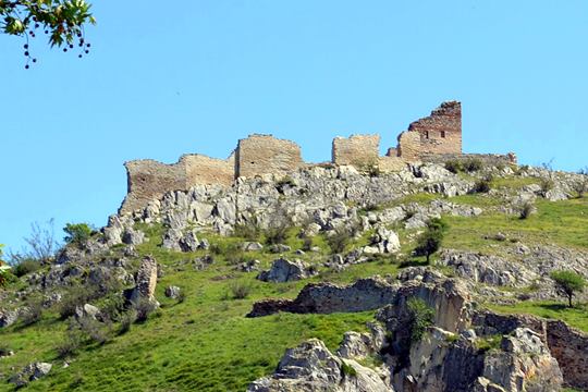
The western side of the castle
4 / 23

From the entrance of the castle
5 / 23

The remains of the western walls
6 / 23

7 / 23

View from the center of the village
8 / 23

The northern side
9 / 23

10 / 23

A glimpse in the interior
11 / 23

Another glimpse in the interior
12 / 23

A photo from the ministry’ sign at the entrance
13 / 23

View from the castle to the north by northwest
14 / 23

The remains of the western walls
15 / 23

16 / 23

the south-eastern corner of the walls
17 / 23

The main tower of the acropolis
18 / 23

The main tower of the acropolis
19 / 23

The main tower of the acropolis
20 / 23

Walking to the entrance of the castle
21 / 23

The east side of the castle
22 / 23

23 / 23


THE END
| Location: |
| On a hill over the village Palaio Gynaikokastro, Kilkis, Central Macedonia |
| Region > Prefecture: |  |
| Central Macedonia Kilkis | |
| Municipality > Town: | |
| City of Kilkis • Gynaikokastro | |
| Altitude: | |
|
Elevation ≈ 170 m (Relative Height≈106 m) |
| Time of Construction | Origin | |
| 1334 | Late-BYZANTINE |
|
| Castle Type | Condition | |
| Castle |
Rather Poor
|
On a hill in the middle of the plains of Central Macedonia, overlooking the village of Palaio Gynaikokastro, lies a castle with the same name and interesting history.
It is one of the most important fortifivcations that were built in the paleologean period of Byzantium.
It is located at the top of a hill in the centre of the Axios River valley, about 59 km north-northwest of Thessaloniki and 15 km west of Kilkis.
History
The castle was built between 1328 and 1341 by the Byzantine Emperor Andronicos III Palaeologos, as part of the fortification programme implemented immediately after his accession to the throne, to strengthen the defences of the Macedonian capital, Thessaloniki, and its environs, and to control the crossings towards western Macedonia.
Legend has it that the fort was so strong it could be defended by a female guard, thus giving rise to the name Gynaikokastro (literally = “Woman’s castle”). The castle was the repeated focus of armed conflict: seized by Stephen Dušan after the Byzantine civil war following on from the death of its founder in 1341, it was then returned to the Byzantines by agreement, but captured by the Ottomans in 1373/74.
In the 15th century Gynaikokastro was granted to an Islamized Byzantine pronoiarios , before finally being abandoned and falling into ruin in the 17th century.
In the early 20th century, systematic removal of building material from the north and west sides to build houses in the adjacent refugee settlement led to extensive damage to the castle walls.
Structure, Fortification & Buildings
Significant parts of the fortification wall remain visible to this day. This encircled the hill summit and part of the slope - to a total length of 614 metres and total area of 25000 sq.m.- and was reinforced by rectangular and semicircular towers.
The citadel is crowned by a central tower with its own chapel , as is evidenced by fragments of fresco. Access to the castle was gained via two gates, one main and one secondary. Inside the walls are traces of a building identified as the living quarters of the garrison permanently stationed there.
| First entry in Kastrologos: | October 2012 | Last addition of photo/video: | June 2022 |
Sources
- Blog protostrator -Γυναικόκαστρο
- ΑΡΧΑΙΟΛΟΓΙΚΟΝ ΔΕΛΤΙΟΝ, issue 62/Β2, 2007, p.902-907
- ΑΡΧΑΙΟΛΟΓΙΚΟΝ ΔΕΛΤΙΟΝ, issue 63/Β2, 2008, p.898
- Video by the user Hellenic Observation Center Γυναικόκαστρο Κιλκίς
|
|
| Access |
|---|
| Approach to the monument: |
| From Thessaloniki follow the road to Kilkis. At the junction to Kilkis, do no turn right, continue towards Doirani. After a few km, there is a turn and a sign "to Leventohori" to the left. The castle is after 9km on this upcountry road. |
| Entrance: |
| Free entrance. There is a dirt road to the castle from the parking at the south end of the village. Or, better, walk to the castle (30min from the parking) on a smooth terrain. |
| Other castles around |
|---|
| Fortress of Aetos |
| Castle of Nea Santa |


