

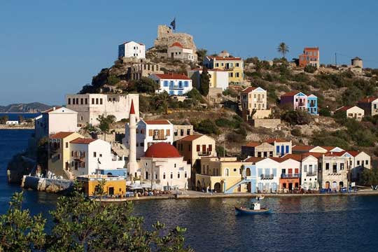
Megisti, Megisti, Dodecanese,South Aegean
Kastellorizo Castle
or Castle of Megisti or Castle of Saint Nicholas


| Location: |
| Kastellorizo, on a rocky hill above the port |
| Region > Prefecture: |  |
| South Aegean Dodecanese | |
| Municipality > Town: | |
| City of Megisti • Megisti | |
| Altitude: | |
| Elevation ≈ 46 m |
| Time of Construction | Origin | |
| 1451 | FRANKISH |
|
| Castle Type | Condition | |
| Coastal Fortress |
Average
|
A medieval castle on a rock dominating the port of Kastellorizo.
Kastelorizo is located 1.25 mile off the coast of Turkey, 72 miles east of Rhodes. It is the easternmost point of Greece.
The Name of the Castle
The island took its name from the castle. Its ancient and official modern name is Megisti but “Kastellorizo” (first recorded in the 12th century AD) is more common and widely used. This name is derived, according to the prevailing theory, from the Venetian Castel Rosso meaning Red Castle. “Red” because the rock gets a reddish hue under certain light conditions.
Depictions of the castle in old maps are titled Castel d’Orizzo or Castel Ruggio. Furthermore, it is Château Rouge in French and Meis or Kızılhisar in Turkish (both meaning Red Castle).
Modern tourist guides refer to the castle as “Castle of Megisti” or “Castle of the Chevaliers”. In historiography, sometimes is referred to as Castle of Saint Nicholas.
History
In 1306 the island was taken over by the Knights of the Order of St. John Hospitaller of Jerusalem, headed by Grand Master Foulques de Villaret. They were on their way from Cyprus to Rhodes. Rhodes was conquered three years later, becoming the centre of their Crusader State.
The knights built the castle on the red rock of the harbor replacing the old Byzantine and previously Hellenistic fortress. This happened probably around 1380. We know this, because it is reported that the emblem of Grand Master of the Order Juan Fernandez de Heredia (1377-1396) used to be engraved above the entrance.
In 1440 the island was plundered by the fleet of the Mameluk Sultan Djemal-el-din Yusef of Egypt, who destroyed the castle. Ten years later, in 1450, Pope Nicholas V ceded the island to Alfonso Magnanimus king of Aragon, Naples, Sicily etc. The Aragonese governor Bernat de Villamari rebuilt the castle. Apparently, the current shape of the castle is the remnant of that period rather of the construction of the Ioannites in the late 14th century.
Kastellorizo remained a possession of the kingdom of Aragon until 1461 when the kingdom was declared extinct by the Pope. After that, Kastellorizo belonged to the kingdom of Naples until 1512 with an interval between 1480-1498 when it was occupied by the Ottomans. In 1512 the Kingdom of Naples was merged with Spain and Kastellorizo passed under Spanish control. This status did not last long, as in 1523 it was captured by the Ottoman Sultan Suleiman I together with the rest of the Dodecanese.
On 22 September 1659, during the war over Crete, the island was attacked by a French-Venetian fleet commanded by Jaques de Gremonville.
The castle was destroyed for one more time, but the Ottomans managed to come back soon. It is very likely that the towers and the bastion were demolished (and never reconstructed) in that occasion, after the departure of the Christian fleet. Until then, it seems that the towers were preserved in full height as depicted in a drawing (fig.1) that was included in a volume reporting the military operations of the 5th Venetian-Turkish war (1645-1669).
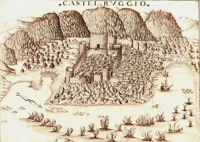
fig.1 – the attack of the Venetian fleet in 1659
Structure, Fortification & Buildings
This is a small castle covering an area smaller than 1000 sq.m.
It consists of two parts: 1) the big central tower at the top of the rock and 2) at a lower level, a fortified courtyard protected by a bastion at its NE side, to the sea.
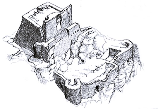
fig.2 – current condition
The big central tower, was not merely the keep (donjon) but the main part of the castle. It measures 17,5✖22,0 m. Its walls on all sides except the NE form a scrapa (slopping wall). The sloping wall is 7.50m high, while its base is formed by a raw (75cm height) of vertically positioned, well-finished large stones. The entrance to the tower is in the NE side (from the yard). There is a small cylindrical tower next to its east side (5m diameter, 5m preserved height), not attached to the main tower, the purpose of which might have been to give access to the upper floors of the central tower.
The scrapa was an innovation of the 15th century. The slopping surface was a way to repel canon balls and to enhance the strength of the wall.
The tower initially was very tall and imposing. The demolished part didn't have slopping walls. What remains today is the part protected by the scrapa, with less than half of the initial height.
Next to the central tower, at its SE side, there are the foundations of a building 7.0✖7.0m with no traces of fortification. This must have been an addition of the Turkish period, probably a mansion.
The second part of the castle is a fortified courtyard 17,5✖6,5 m with maximum preserved wall height 3m. Two cylindrical towers (diameter 7m, current height 5m and 7m) protected the two corners of the NE side, the one towards the sea. This side was also protected by the strong bastion (with flat outer surface, not pointed). The maximum height of the bastion today is 5m. Its initial height must have been about 20m to effectively protect the castle against bombardment from the sea.
The French architect and archaeologist Albert Gabriel was in Kastellorizo between 1915 and 1917 when the island was occupied by the French fleet during WW I. Garbriel studied the castle and is the source of valuable information about it, though the castle was not in much better condition those days. He also created a beautiful recreation of the castle (fig.3).
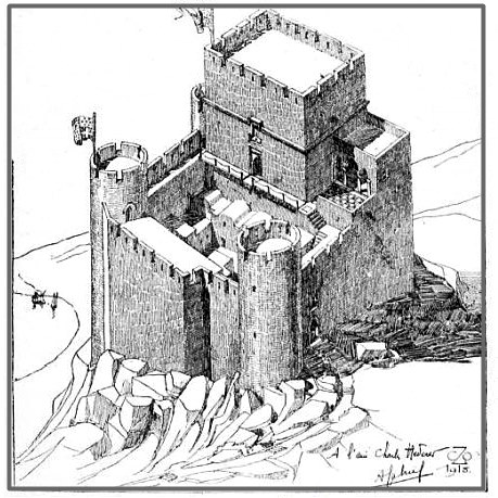
fig.3 – representation of the castle
This recreation is based on the gravure of the battle of 1659 (fig.1) and on a drawing by the Dutch geographer Olfert Dapper since 1703 (not available anymore).
Today, close to the castle ruins, we see an old Turkish bath and a restored windmill. Right under the castle, in a niche on the rock, there is a 4th cen.BC Lycian tomb with very interesting architecture.
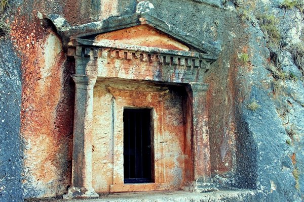
fig.4 – the Lycian tomb
| First entry in Kastrologos: | September 2012 | Last update of info and text: | November 2019 | Last addition of photo/video: | November 2019 |
Sources
- M. Zotos, The red castle of Castellorizo: The Island’s strategic significance and the castle’s historical representations, Architecture School, National Technical University of Athens, Greece
|
|
| Access |
|---|
| Approach to the monument: |
| - |
| Entrance: |
| Free access to the perimeter and to the keep. |
| Other castles around |
|---|
| Konaki of Kastellorizo |
| Palaiokastro of Kastellorizo |
| Fort of Ro island |


