

Kastri, Agia, Larisa,Thessaly
Castle of Kastri
1
2 / 20

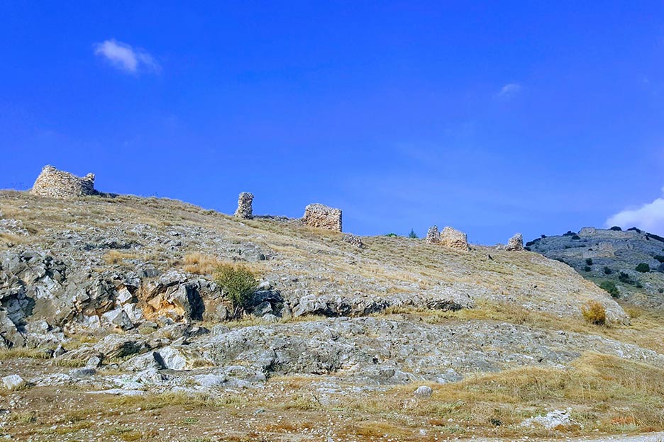
the southeast side of the hill of the castle
3 / 20

the southeast side of the hill of the castle
4 / 20

the southeast side of the hill of the castle
5 / 20

part of the SE wall
6 / 20

tower in the middle of lower SE side
7 / 20

tower at the SE edge
8 / 20

the southeast side of the hill of the castle
9 / 20

the upper part of the castle
10 / 20

the upper part of the castle
11 / 20

the keep of the castle
12 / 20

the tower on the other side of the road
13 / 20

the tower on the other side of the road
14 / 20

the northwest slope of the hill of the castle
15 / 20

the northwest slope of the hill of the castle
16 / 20

tower of the NW slope of the hill
17 / 20

part of the wall of the NW slope
18 / 20

view from the SE
19 / 20

view from the SE
20 / 20

distant view from the SE

THE END
| Location: |
| Kastri, Agia, Larissa region, Thessaly |
| Region > Prefecture: |  |
| Thessaly Larisa | |
| Municipality > Town: | |
| City of Agia • Kastri | |
| Altitude: | |
|
Elevation ≈ 125 m (Relative Height≈40 m) |
| Time of Construction | Origin | |
| perhaps 10th cent. | BYZANTINE |
|
| Castle Type | Condition | |
| Byzantine City |
In Ruins
|
A byzantine castle and settlement on the western slopes of the mountain Mavrovouni, south of the town Ayia and above the modern village Kastri.
Location & Strategic Scope
The castle is on a rocky hill, part of the mountain Mavrovouno which lies east of the castle. This spot surveys a large part of the plain of Larissa, the exit from the sea passage around Kissavos mountain, the entrance to the plain of Ayia and the road from Larissa to Volos.
It was a strong position not only because of the rough rocky terrain but also because the lake Karla was reaching at the foot of the hill. The lake was dried in 1962.
History
The castle is built at the location of an ancient fortification. We do not know the ancient neither the early medieval name of the place.
Some scholars believe that here might have been the ancient city Kerkineon which is also mentioned by the historian Procopius as one of the fortresses built during the reign of emperor Justinian in the 6th century AD. But its rather unlikely that this was really Kerkineon, so it was not a 6th century fortress..
The castle appears for the first time in history in the 14th century, but it was probably constructed much earlier.
The most probable chronology for the foundation of the castle is the 10th century, around 920 AD, when the Byzantine emperor Romanos I Lekapenos built several castles in Thesaly and Western Macedonia to contain the Bulgarians who under the rule of Symeon had started to invade for the first time this part of Greece (as opposed to Thrace, which was the theater until then of their conflict with Byzantium).
Around the end of the 10th to the beginning of the 11th century, a diocese named Katria or Kastria is reported in Thessaly. This place is identified with Kastri.
After 1204 the castle must have been briefly under Frankish conrol. Then after 18 years became part of the Despotate of Eporus and after 1263 belonged to the autonomous state of Thessaly founded by Ioannis Doukas, the son of the despot of Epirus Michael II. This state lasted until 1318 when the last descendant of Ioannis died childless. After that, the principality was dissolved. A large part, in Central Greece, was taken by the Catalans of the Duchy of Athens. Another part including Kastri passed under the independent rule of Stefanos Gavriilopoulos, a rich Greek lanlord who managed to acquire the official recognition of Constantinople.
Gavriilopoulos died in 1333. Following his death, the capable governor of Thessaloniki Michael Monomachos invaded Thessaly and took possession of the castles in the name of the emperor Andronicos III Palaiologos including Kastri.
However, it is possible that Gavriilopoulos was only typically the ruler of Kastri. The 19th century Catalan historian Rubio y Lluch reports that a Greek named Misilino (Μελησσινός) was the lord of the castle, who was a vassal of the Catalans and married his sister to the Catalan general Odon de Noveles .
In any case, Kastri was captured by the emperor Ioannis Kantakouzenos in 1350 and for some time (not very long) remained under Byzantine control. Apparently, the castle had gained some importance being at the frontiers with enemy states like the Catalans of the Duchy of Athens and the Serbians who had taken Epirus.
In 1380 according -again- to Rubio, the castle was Catalan named “Castel des don Estanyol ” and owned by Misili de Novelles Senyor who must have been an offspring of De Novelles and his Greek wife.
In 1423 Thessaly was conquered by the Ottomas and the history of the castle ended there.
Structure, Fortification & Buildings
The castle has a triangular layout adapting to the rough, rocky terrain. It covers a total surface of 32,000 sq.m. enclosed by walls around 900m long. At the top, at the northeastern corner is the inner keep of the castle with an area of 3,000 sq.m. and a wall perimeter of 230m.
Except of the keep, the interior is divided in two partitions by a transverse internal wall.
Most of the walls are not preserved, but there are several remains to show the initial layout. Several towers are preserved to some height: one triangular at the western side, 3 circular and one triangular at the eastern side. There is no sign of a gate but it must have been at the middle of the eastern side.
At the foot of the hill, outside the castle and on the opposite side of the country road are the ruins of a big square tower. It is not clear if the fortification used to reach this point. If so, part of it has been destroyed when the road was constructed.
At the lower part of the castle there is a byzantine chapel dedicated to Saint George. It is dated to the 12th or 13th century but its initial form has been altered due to recent renovations.
| First entry in Kastrologos: | November 2012 | Last update of info and text: | July 2018 | Last addition of photo/video: | July 2018 |
Sources
- Photos from the website Γρηγόρης Καλαγιάς - ΒΥΖΑΝΤΙΝΟ ΚΑΣΤΡΟ ΣΤΟ ΚΑΣΤΡΙ
- Pictures by George Rodinos from the website Αρχαιολογικά Θέματα, Νομός Λάρισας - Δήμος Λακερείας: Αρχαιολογικός χώρος στο Καστρί.
- J. Darrouzès, Notitiae Episcopatuum Ecclesiae Constantinopolitanae. Texte critique, introduction et notes,Paris 1981.
- Pictures by Kastrologos - November 2018 (all except 3, 8)
|
|
| Access |
|---|
| Approach to the monument: |
| - |
| Entrance: |
| Free access |
| Other castles around |
|---|
| Tower of Agioi Anargyroi monastery |
| Castle of Kokkino Nero |
| Castle of Skiti |
| Tower of Tsiligiorgis |
| Castle of Velica |


