

Peratata, Argostoli, Cephalonia,Ionian islands
Saint George Castle
or Kefalonia Castle


| Location: |
| Kefalonia, country road to Peratata village |
| Region > Prefecture: |  |
| Ionian islands Cephalonia | |
| Municipality > Town: | |
| City of Argostoli • Peratata | |
| Altitude: | |
|
Elevation ≈ 320 m (Relative Height≈100 m) |
| Time of Construction | Origin | |
| 12th century | VENETIAN |
|
| Castle Type | Condition | |
| Fortress-state |
Not Good
|
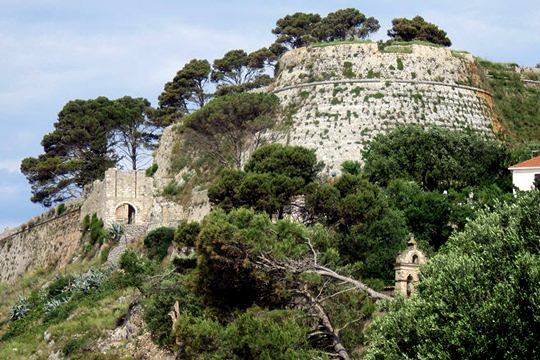
The castle is on a hill 7 km from Argostoli and dominates the south part of island of Cephalonia and the bay of Argostoli. The building of the castle started by the Byzantines and it was completed by the Venetians. It was the administrative center of the island until the 18th century, when the capital was moved to Argostoli.
History
Having fallen in succession into the hands of the Byzantines, the Franks and the Turks, at the end of the year 1500 the Venetians liberated the castle from the Turks with the help of the Spanish armada and the people of Kefalonia. For the following four years the Venetians proceeded to restore and fortify the castle walls with the work being supervised in 1504 by the engineer Nicolo della Cimara.
A 'borgo' or suburb was built in the front of the castle and this is the area called Kastro. The work was carried out by 40 Venetian craftsmen and local forced labour.
The road leading to Argostoli from the castle was named Strata Communa and runs behind the hill which was planned to ensure that it would not be seen by passing ships.
The construction of the castle finished in 1545 and it soon became the economic, cultural and administrative center of the region until the late 18th century (1757) when the capital was transferred to Argostoli.
The two devastating earthquakes of the 17th century and the one of 1953 caused extensive damage to the castle’s fortifications and buildings.vangelistria which was built on the other side of the hill.
Structure, Fortification & Buildings
The polygonal walls of the castle are 570 metres in length. It covers an area of 18,000 square metres and is 320 metres above sea level. The castle is divided into two parts with a horseshoe shaped interior courtyard with a rocky rise at its centre.
There are three main bastions with one facing Argostoli, one facing the sea and the third facing the village at the entrance. The coats of arms of various ruling Venetian families can be found on the walls within the castle.
| First entry in Kastrologos: | April 2012 |
Sources
- Video by G Traveller Κάστρο Κεφαλονιάς - Kefalonia Castle
|
|
| Access |
|---|
| Approach to the monument: |
| The castle is on a hill, 7km east of Argostoli. In the village of Peratata there is a road leading to the hill. |
| Entrance: |
| The castle is temporarily closed (?) |
| Other castles around |
|---|
| Vardiola of Atheras |
| Vardiola of Koutsoupia |
| Kasteli of Paliki |
| Vardiola at Piniatoros’ property |


