

Vryssi, Kymi-Aliveri, Euboea,Central Greece
Couppa Castle
or Dragonara Castle
1
2 / 21

3 / 21

4 / 21

5 / 21

6 / 21

7 / 21

8 / 21

9 / 21

10 / 21

southwest gate of the east part of Coupa castle
11 / 21

east wall, before the chapel
12 / 21

western part
13 / 21

western part
14 / 21

15 / 21

16 / 21

17 / 21

18 / 21

the western part (G Traveller-Aug 2023)
19 / 21

the western part (G Traveller-Aug 2023)
20 / 21

the western part (G Traveller-Aug 2023)
21 / 21

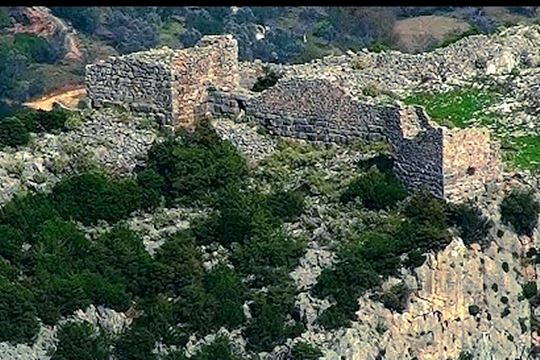
Dragonara hill from the east

THE END
| Location: |
| On a hill west of the village Vryssi of central Evia |
| Region > Prefecture: |  |
| Central Greece Euboea | |
| Municipality > Town: | |
| City of Kymi-Aliveri • Vryssi | |
| Altitude: | |
|
Elevation ≈ 290 m (Relative Height≈110 m) |
| Time of Construction | Origin | |
| Various periods | ANCIENT |
|
| Castle Type | Condition | |
| Castle |
Rather Poor
|
An ancient castle which was in use continuously from antiquity until the ottoman conquest.
Location & Strategic Scope
The castle is atop a hill named Dragonara or Tragkounara at the eastern foothills of Mount Mavrovouni and west of the village Vryssi near Kimi in Evia. Down the hill flows Manikiatis stream. On the opposite side of the stream there is another steep rocky hill, the Sarakinokastro (with ruins of another castle at the top) so a narrow passage is formed there with strategic importance. To the east of the hill there is a fertile plain.
Dragonara is an elongated rocky hill with ruins of fortifications scattered for over 650 meters in a straight line.
The western part of the fortification is somehow autonomous, situated at some distance from the rest of the castle (250 meters from the western wall of the eastern side) and a little higher (elevated 75 meters). In addition, the eastern part was built in the location of the ancient city and encircled a medieval settlement. The western part was simply a powerful military outpost.
This diversity and somewhat independent position made some researchers to believe that there are two castles on Dragonara (eg Swiss Archaeological School).
Most, however, consider it a single castle (like, Skouras, 1975). In Kastrologos we will adopt this view and will record the castle as a single fortification with two parts: the eastern part and the western part.
There are some good reasons for this choice: 1) the distance of the two fortifications (250m) is too small to be considered as separate, 2) historical sources and old maps indicate one castle at Cuppa, 3) the defensive role of the two fortifications was the same, defending the same position with a single military unit, 4) the chronology of the two castles (construction and operating life time) coincide: both were built during the Hellenistic period; the western part was built soon after the eastern one, apparently when it was realized that the hill was vulnerable from the west, particularly if a hostile power could be camped on the plateau of the western part.
Some visitors have described the western part as the citadel of Cuppa. This desription is justified but not correct. A typical citadel would be the administrative center and the ultimate point of the defense but this was not the case of the western part as explained already.
Most photos on this site are from the western part.
The Name of the Castle
On the northwest side of the hill of Dragonara is a spectacular cavity, from the top to the foot of the hill, which has a smooth concave surface resembling a half cup. Hence the name Couppa or Koupa meaning mag. The name was first used by the Franks.
History
The castle was fortified for the first time probably in the 4th BC century - as shown by the impressive isodomic walls built with big and well refined rectangular blocks. As mentioned above, the western part was built a little later.
The ancient name is not known precisely. It is assumed that this was either Oichalia (of Evia) or the city or Vrynchai or Grynchai (meaning "Fountains") which had been destroyed by a landslide.
The original fortification was not changed dramatically over the centuries. Some little additions attest to the use of the castle as a military fortress during the Roman and Byzantine period and certainly during the Frankokratia.
In the 8th AD century at a time when the Byzantine Empire was in decline, the castle was captured by Saracen pirates and suffered serious damage.
In 1208, in the befinning of the Frankokratia in Evia, the castle passed into the hands of the Franks and became an important link in the defense system of the island. The Franks called the castle La Cuppa, name that remained until today.
In 1269, La Cuppa fell into the hands of Knight Likario who had conquered many castles of Evia on behalf of the Byzantine emperor Michael VIII Palaiologos. Towards the end of the 13th century, Franks and Venetians retook back their possessions in Evia including La Cuppa which became the administrative center of the region.
In the early 15th century, the area was occupied by the Catalans of Athens Duchy. In a Catalan document of 1413 the castle is mentioned again as a military center.
In 1470, the castle was conquered by the Turks under the leadership of Mehmed II himself. The 3000 defenders who were captured were slaughtered, and, according to a witness (Jacopo dalla Castellana), this happened in front of the walls of the castle of Halkis to break the morale of the defenders there.
The Ottomans destroyed the castle after its capture and then not used again.
Structure, Fortification & Buildings
The eastern part has an area of approximately 4 hectares. It has walls only at places, because the fortification is supplemented naturally by craggy rocks. On the southeast side there is a spring and further on the remains of a gate.
In the center of the eastern part there is the church of Panagia Dragoniera celebrating 1st August. On this day many people walk uphill to the castle. In the courtyard of the church there are broken ancient columns. These, as well as the seven marble columns supporting the roof, reveal the existence of an ancient temple in the area, believed to be of Artemis.
This part was the location of the ancient city that was replaced by the medieval settlement. Most of the walls are ruins of the ancient fortifications (carved stones in isodomic building system without mortar) but there are parts of the wall, especially east of the church, dating back to medieval times.
The western part was a supplementary fortification for the protection of the eastern part and, as mentioned above, had a more military character. It is preserved in relatively better condition. It is a plateau that from the north and south is protected by cliffs. On these sides walls are unnecessary; nevertheless on the north side there is 100 meters long wall.
The west side of the plateau is protected by a wall of 24 meters, between two towers. The northerly tower is ancient, measured 9.8✖7.0m. Near the tower there is a small entrance 0.9m wide which is accessible by a staircase of 9m. The south tower is a medieval construction.
The walls have a thickness of 2.65 meters. The masonry is similar to that of the eastern part, but here a few points have been repaired with the use of bricks and mortar.
The east side seems without a serious fortification (unless it disappeared because of the destruction of the castle by the Ottomans). The absence of eastern wall is justified as from that side lies the rest of the castle.
| First entry in Kastrologos: | March 2013 | Last update of info and text: | October 2016 | Last addition of photo/video: | August 2023 |
Sources
- Θεόδωρος Σκούρας, «Οχυρώσεις στην Εύβοια (Μερικές λύσεις στα τοπογραφικά τους προβλήματα)»- ΑΕΜ – Τόμος Κ’ – 1975
- Swiss School of Archaeology in Greece - 2005 Archaeological report
- SYLVIAN FACHARD, Αρχαιολογικό Δελτίο 60-Β1 (2005), p.423-425
- Video by the user Prokopis Koiliaris Κάστρο Κούπα
- Photos 18, 19, 20 and video by G Traveller Κάστρο Κούπα | Couppa Castle (August 2023)
|
|
| Access |
|---|
| Approach to the monument: |
| - |
| Entrance: |
| Free but difficult access |


