

Livadia, Tilos, Dodecanese,South Aegean
Castle of Lambros
or Castle of Stavros


| Location: |
| On a rocky hill above the bay of Stavros, Tilos island, Dodecanese |
| Region > Prefecture: |  |
| South Aegean Dodecanese | |
| Municipality > Town: | |
| City of Tilos • Livadia | |
| Altitude: | |
| Elevation ≈ 300 m |
| Time of Construction | Origin | |
| Mid-Byzantine period | BYZANTINE |
|
| Castle Type | Condition | |
| Castle |
Rather Poor
|
A most probably Byzantine castle, re-used by the Hospitaller Knights; on a strongly jagged ridge of the north-northwest limestone spur above Stavros Bay in Tilos.
Castle Description
Text: Dr. Michael Losse – Singen (Hohentwiel), Germany (30.10.2021)General Description
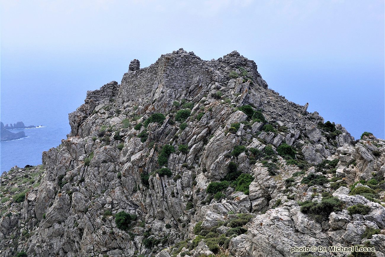
The fortification known as "stó Stavró" and "Kástro tóu Lámbrou" (Gerola II 1916, p. 19: "Stavròs [o tu Lámbru to Kástro]"; Dawkins/Wace 1905-06, p. 164: "probably the Lamprida of the Italians") is situated on a strongly jagged ridge of the north-northwest limestone spur above Stavros Bay, which faces from north to south. Except from the ridge to the north, the spur is almost “inaccessible” all around because of its steep slopes. The mountain peak rising north of the Kástro reaches an altitude of 395 m.
Despite its location above the south and southwest coast of Tilos, Kastro, which stands about 1.5 km from Livadia – together with Agriosykia, Faneromeni and Kastellos – is one of the fortifications surrounding the large harbour bay of Livadia. The Kastro’s location offers visual connections of Livadia bay with the Kastro Faneromeni as well as to the Palaiokastro above the Eristos Bay (see photo No. 3) and many other places on Tilos, such as mountain peaks that could be used as vigles (a. e. the mountain north of the Kastro occupied by radio and transmission masts of the OTE.).
Also visible are the neighbouring islands of Chalki, Karpathos, Astypalaia, Strongyli (near Nisyros), Kos, Kalymnos, Symi and the west coast of the island of Rhodes.
The original way to the Kastro is not preserved; the slope area below was formed by the creation of arable terraces (see photos 1 and 2). It probably led up the east side of the mountain. Here, the arable terraces have slipped so much that a large scree heap was created. Above, the largely abandoned access ramp to the gate of the Kastro began. The access via ramps and stairs that bridge rock ridges is similar to that of Kastro Agriosykia near Livadia.
The Kastro has an irregular ground plan adapted to its location, a spur top of coral limestone. Its enceinte is made of limestone masonry in two-shell technology; it was apparently drywalled (?) in some areas. On the inaccessible east side, on the other hand, there seems to be mortar masonry, which was even covered with mortar or plastered in the area above the access ramp.
The building material was the flat-breaking rock of the mountain. It was probably also mined in the area of the shallow “trench” (in the form of a shallow depression) and on the ridge‘s surface.
Where the largely well-preserved enceinte forms corners, they were stabilized with rectangular stones. The wall has an average thickness of about 1.20 m; due to bellions and overhangs, the original thickness can no longer be determined in some areas, but it may have had a similar thickness there as well.
Remarkable are the wall areas at the southern tip of the castle, consisting of large-format, only slightly processed stones. It would have to be investigated whether there are remains of an older (ancient?) fortification.
A gate that is now impassable due to collapse inside the castle (it forms a combination of wall gate and tangential gate) opened on the east side to the northeast. The gate lies within a crack of the enceinte, so that a partly flanking defense was possible. This principle, known already from antiquity, can also be found on other fortifications on the island of Tilos, such as Kastro Agriosykia and Kastro of Megalo Chorio.
An embrasure (for the use of firearms?) in the eastern section of the defensive wall on the side of the gate apparently served to defend the ramp path (cf. Kastelli, Island of Kos).
Inside the Kastro, remnants of buildings have been preserved under collapse. It seems that some of the buildings on the west side tie into the enceinte wall. Striking are several dry masonry buildings, which are certainly to be regarded in this form as post-medieval, because under some of their walls are foundations of (mortar?) Masonry in two-shell technology visible. Maybe they were part of a peasant settlement inside the Kastro in the (early) Modern times.
Access
Access via largely slipped arable terraces (scree heaps!) running northeast of the castle, which are difficult to access due to the unpaved embankments created during road construction in recent years, up to the saddle in front of the fortification.
The actual access to the partially dilapidated Kástro is also largely collapsed, the slope area below is buried by scree.
A visit is therefore quite dangerous, especially since the dilapidated enceinte must be climbed over.
History of the castle
Dates on the origin and history of the Kastro are not known. Its two common names are to be interpreted as popular names: "sto Stavro", i.e. "to the (Holy) Cross", was derived from the patronage of the Stavros Chapel standing southeast below the Kastro, while the name "Kastro tou Lambrou", i.e. "Castle of Lambros", probably can be traced back to a person (who had property here?).
A use and expansion of the castle, which is said to have been built in Byzantine times (Koutelakis, p. 13) during the period of the Knights Hospitallers‘ reign is very likely. The Muslim raids on the island in the 15th century speak for the expansion of the castles on Tilos by the Knights of St. John. In 1444, the Knights Guido di Domaigne and Ettore d'Alemagna came to Tilos to take measures to re-fortify or strengthen castles (Hasluck 1910-11, p. 166).
In 1457, Turks devastated Tilos; they felled trees and robbed cattle after failing to capture a castle (Koutelakis, p. 14). Residents of Tilos were evacuated to Rhodes (Kollias 1988, p. 16), "because defence proved weak and food was insufficient" (Koutelakis, p. 14).
In 1485 the island is said to have been attacked again (Kollias 1990, p. 203), and in 1505 the corsair Camali made an attempt to conquer Tílos (Dawkins/Wace 1905/06, p. 165, note 4).
Fragments of predominantly coarser utility ceramics made of unglazed, red to red-gray clay which can be found inside the castle have not yet been analyzed.
The Kastro was probably used militarily in the 2nd World War, like the ruins of a building on the eastern rocky slope below the castle witness, which was formerly covered with a pitched roof. Such buildings of the Italians can be found in many places in the mountains of the Dodecanese, especially on the island of Kalymnos.
Other Info
SourcesDawkins, R. M./Wace, Alan J. B.: Notes from the Sporades, Astypalaea, Telos, Nisyros, Leros. In: The Annual of the British School at Athens (BSA), No. XII, 1905-1906, S. 151-174.
Gerola, Giuseppe: I monumenti medioevali delle 13 Sporadi. In: Annuario Scuola Arch. Atene I, 1914, pp. 319-356; II, 1916, pp. 29-54.
Hasluck, F. W.: Depopulation in the Aegean Islands and the Turkish Conquest. In: The Annual of the British School at Athens (BSA), No. XVII, Session 1910-1911, pp. 151-181.
Kollias, Elias: The City of Rhodes and the Palace of the Grand Master. Athens 1988.
Kollias, Elias: The Knights of Rhodes. Athens 1991.
Koutelakis, Haris M.: Tilos. Art, History, Archaeology. Athens (without specifying the year of publication).
Losse, Michael: Burgen und Befestigungen des Johanniter-Ordens auf den Dodekanes-Inseln Tílos, Chálki und Alimiá (Teil 1). In: Burgenforschung aus Sachsen (Editor: Heinz Müller, Deutsche Burgenvereinigung, Landesgruppe Sachsen), Vol. 17/2, 2004, pp. 98-129; Vol. 18/2, 2005, pp. 135-157.
Losse, Michael: Die Burgen und Festungen des Johanniter-Ritterordens auf Rhódos und in der Ägäis (Griechenland) 1307-1522. (Publisher: Nünnerich-Asmus Verlag) Mainz 2017.
Losse, Michael: Burg und Expansion in der Südost-Ägäis: Von den byzantinischen Befestigungen der „Dunklen Jahrhunderte“ (7.-10. Jahrhundert) bis zu den Invasionen der „Franken“ (13./14. Jahrhundert) und Osmanen (15./16. Jahrhundert). In: Joachim Zeune (Ed.): Burg und Expansion. Kolloquium des Wissenschaftlichen Beirats des Deutschen Burgenvereinigung Brandenburg 2019 (Veröffentlichungen der Deutschen Burgenvereinigung e. V. Hrsg. vom Europäischen Burgeninstitut – Einrichtung der Deutschen Burgenvereinigung. Reihe B: Schriften, Bd. 18; zugleich Arbeitsberichte zur Bodendenkmalpflege in Brandenburg, Bd. 36, hrsg. von Franz Schopper). Braubach 2021, pp. 107-124.
| First entry in Kastrologos: | November 2012 | Last update of info and text: | November 2021 | Last addition of photo/video: | November 2021 |
Sources
- Article (and photos 1,2,6 [2008], 3[2006]) by Michael Losse
|
|
| Access |
|---|
| Approach to the monument: |
| - |
| Entrance: |
| Free but dangerous and difficult access |