

Kalamafka, Ierapetra, Lasithi,Crete
Mesokastela
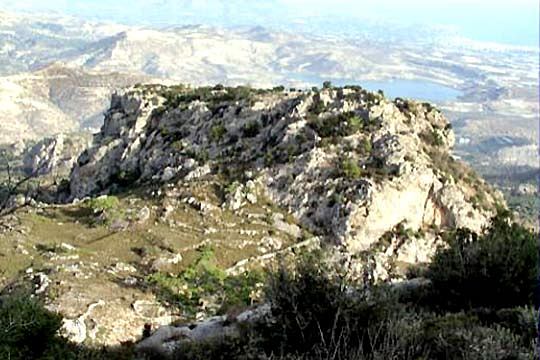
1
2 / 11

the plateau between the rocky hills
3 / 11

gate of the first hill
4 / 11

the first hill
5 / 11

the plateau between the rocky hills
6 / 11

the plateau between the rocky hills
7 / 11

tower at the first hill
8 / 11

wall of the first hill
9 / 11

wall of the first hill
10 / 11

wall of the second hill
11 / 11

west wall

THE END
| Location: |
| On a rock NW of Ierapetra in Crete, between the villages Kalamafka nad Anatoli |
| Region > Prefecture: |  |
| Crete Lasithi | |
| Municipality > Town: | |
| City of Ierapetra • Kalamafka | |
| Altitude: | |
|
Elevation ≈ 650 m (Relative Height≈200 m) |
| Time of Construction | Origin | |
| Between 10th-12th cent. | BYZANTINE |
|
| Castle Type | Condition | |
| Natural Fort |
In Ruins
|
A fortified position the name of which is still Mesokastela meaning “in the middle of castles”.
Location & Strategic Scope
It is a plateau which is protected by four rocks. Two of the rocks have fortifications on them. The space between the rocks has water springs and could be cultivated. It was also invisible from the nearby passages and from the sea, which was a serious advantage in difficult periods. Furthermore, from the top of the rocks one could observe a large part of the south coast of Crete and of the Isthmus of Ierapetra (the narrowest part of Crete between the Aegean and Libyan sea).
History
A settlement existed among the four rocks during the Roman and the early-Byzantine periods. Regardless of the lifespan of the settlement, the position was used as a castle-refuge from the Minoan era until perhaps the Venetian period.
The fortifications were constructed most probably in the second Byzantine period, i.e. after the expel of the Saracens in the 10th century. During that period, it must have been a military fort. It was abandoned before 13th century, since it is not reported in any Venetian inventory.
| First entry in Kastrologos: | November 2015 |
Sources
- Nikos M.Gigourtakis , Monograph in the History Department of the University of Crete, “Byzantine fortifications in Crete in the 2nd Byzantine period (961-1204)”, Rethymno 2004
|
|
| Access |
|---|
| Entrance: |
| Free access |
| Other castles around |
|---|
| Tower of Ambela |
| Koules of Episkopi |
| Kales of Ierapetra |
| Byzantine walls of Ierapetra |
| Fortification of Oxa |
| Tower of Vaïnia |
| Koules of Vasiliki |


