

Nicopolis, Preveza, Epirus
Nicopolis
1
2 / 18

west side from the inside
3 / 18

west side from the inside
4 / 18

west side from the inside
5 / 18

west gate (“Arapoporta”)
6 / 18

west side and west gate from the inside
7 / 18

west gate (from inside)
8 / 18

the west gate; photo Andy Sawyer
9 / 18

view from S-SE
10 / 18

south gate
11 / 18

the wall next to the south gate
12 / 18

the south wall
13 / 18

the south wall
14 / 18

southeast tower of the byzantine walls
15 / 18

wall of the north gate (photo 1896, not preserved)
16 / 18

the SE gate of the Roman wall (and a tower)
17 / 18

ruins of the basilica of Alkison
18 / 18


THE END
| Location: |
| Archaeological site of Nicopolis, north of Preveza, Epirus |
| Region > Prefecture: |  |
| Epirus Preveza | |
| Municipality > Town: | |
| City of Preveza • Nicopolis | |
| Altitude: | |
| Elevation ≈ 20 m |
| Time of Construction | Origin | |
| mid 6th cent. | BYZANTINE |
|
| Castle Type | Condition | |
| Byzantine City |
Average
|
Nicopolis was the most important city of Epirus during the Roman and the Early Byzantine Periods.
Its ruins are a rare example of a Roman and a Byzantine city. A large Roman wall was built to fortify Nikopolis and 5 centuries later a smaller Byzantine fortification was built.
There is no other place where an Early-Byzantine wall is preserved to such a length and height.
History
The short history of Nicopolis is this: It was founded by the Romans at the end of the 1st century BC and was a populous and prosperous city until the 3rd AD century. Then it began to decline and became the target of barbarian raids. It had to be fortified with a Byzantine wall in the middle of the 6th century, and it was reduced to a much smaller area. A dark period of decline followed until its final abandonment in the 8th or 9th century.
In more detail:
Nicopolis (=city of victory), was founded in 29 BC by the Roman emperor Octavian Augustus in commemoration of his great victory against the forces of Mark Antony and Cleopatra in the world-historical naval battle of Actium, in 31 BC.
Actium was the turning point which marked the end of the Hellenistic Period and the beginning of the most brilliant era for Rome. It was also the starting point of the Pax Romana.
Roman writers call this city Nicopolis Romana Colonia, Civitas Libera Nicopolitana and Colonia Augusta.
Augustus threw a lot of money into the project. He decorated Nicopolis with temples, streets, mansions and grandiose monuments. The work was done at a very fast pace. One of the main financiers of the constructions was the well-known king oh Judea Herod I, who wanted to have a good relation with Augustus. (Perhaps Herod's involvement was also related to the presence, from the beginning, of a large Jewish community in Nicopolis.)
Augustus also brought back the ancient games that were held there every 4 years, the Actia to honor his patron god Apollo. The Sanctuary of Apollo became the religious center of the city. There Octavian dedicated the rams of sunken enemy ships (one of them has been found). Apollo who was worshiped here also had the surnames Lefkadios and Agyeus.
Octavian, in addition to financial privileges, gave Nicopolis the six votes of the Aetolians in the Delphic Amphictyonia. This fact plus the financial privileges plus the continuous favor of the emperor brought the city glamor and rapid growth.
The new city could not be without a wall. But as mentioned above, it was a time of Rome's omnipotence and of peace, so fortifying the city was not a top priority. The Roman wall was long, about 5 kilometers, but not particularly strong. It was incomplete in some places and did not have many towers. This first wall gives the impression that it was built only for compliance with the rules of Roman town planning and not because they considered it necessary.
For the city to exist, however, residents had to be found. The Romans gave incentives to the people of Epirus and Aetoloakarnania to move to the new city. And when this did not prove sufficient, transfers of populations from other places were made by force. Many cities in western Greece were then deserted because of Nikopolis, such as neighboring Ambrakia (today's Arta).
The new Roman city was impressive in size. Its area reached 1,500,000 sq.m., while important monuments of the city such as temples, the monument of Augustus and the ancient theater were outside the walls. Archaeologists today believe that the population must have been 60,000 to 100,000. It was a big city by the standards of the time.
Strabo, as early as the 1st BC. century, writes that it is a prosperous city, receiving new wealth every day.
One of the notable aspects of the cultural history of Nicopolis is that the Stoic philosopher Epictetus lived there for many years. Coming to Nicopolis when the emperor Domitian expelled the philosophers from Rome, about 94 AD, Epictetus founded a school of philosophy in Nicopolis, where he remained until his death in 138 AD.
Around 110 AD Nicopolis became the capital of the new province (procurator Augusti) of Epirus which was formed from areas of Macedonia, Achaia, present-day Epirus, Aetoloakarnania, and the Ionian Islands .
Of Roman emperors, the city was visited by Nero in 66 AD, when he “won” the chariot races in Actia, and Hadrian in 128. Hadrian is probably the one who ordered the construction of the great aqueduct. Hadrian's wife, Vivia Savinna, was deified and worshiped in Nicopolis as Artemis Celcaia (whose cult existed only in Nicopolis).
Roman Nicopolis flourished from the time of its foundation until the middle of the 3rd AD century. Then began its decline due to the general conditions that caused serious problems in the economy and administration of the Roman Empire. And of course the main reason was that with the end of the Pax Romana, the barbarian invasions began.
In 267 AD Nicopolis received the first major blow when it was captured and plundered by the Heruli (a people of German origin who had looted Athens, Corinth and Olympia that year and destroyed the ancient monuments).
During the period 285-305 AD, in the administrative reform of Diocletian, Nicopolis became the capital of Old Epirus (Epirus Vetus) , which included today's Epirus, Acarnania, Corfu, Lefkada and Ithaca.
A second great disaster was brought to Nicopolis in 397 AD by Alaric's Visigoths who had also previously plundered the rest of Greece before passing through Nicopolis. Alaric occupied Epirus until 401. In addition, there is a testimony (from Iordanis the Alanus) that the Visigoths had sacked Nicopolis even before, in 380.
Nicopolis suffered the greatest destruction during the raid of the Vandals in 474 AD. During this period, pirate ships from the Vandal kingdom of North Africa made continuous raids on the coasts of Italy, western Greece and the Peloponnese, culminating in the raids of 467 and 469.
In 474 (or perhaps in one of the earlier raids) the Vandals sacked Nicopolis and took with them a large number of prisoners. In 475 the Byzantine emperor Zeno sent the senate Severus to negotiate with the old king of the Vandals Gizerichus in Carthage and there, beyond all expectations, Severus succeeded in freeing most of the captives by paying a ransom. In 476, a supplementary agreement was made by which Zeno recognized the possessions of the Vandals in the western Mediterranean thus effectively abandoning the old Roman doctrine of mare nostrum.
Some historians believe that then, at the end of the 5th century, during the reign of Zeno or his successors, the early-Christian wall was built to replace the Roman one, as there was an urgent need to protect the city, while the old Roman wall had proved insufficient and perhaps too long. But there is no archaeological evidence for this logical hypothesis.
What we do know is that the historian Procopius attributes the Byzantine fortification to the emperor Justinian, as he writes in About buildings listing the numerous fortification works of Justinian, he renewed Nicopolis.... According to this evidence, Nicopolis acquired its Byzantine wall around the middle of the 6th century.
Byzantine Nicopolis was poorer and much smaller than Roman Nicopolis. For this reason, the Byzantine wall enclosed a much smaller area. But it was a high and strong wall with 35 towers. Around the same time, in the 6th century, the construction of large Christian churches in the city was completed.
A little later, in 551, the Germans came again! In the midst of the Gothic war and Narses' operations against the Ostrogoths in Italy, the Ostrogothic king Totila sent a fleet of 300 ships to western Greece as a distraction. The Gothic fleet, after raiding the Ionian Islands, plundered the villages around Dodoni and Nicopolis. The sacking of Nicopolis by Totila's troops was devastating, but it survived for a little while longer as it is reported that big projects (construction of basilicas, mainly) continued in the second half of the 6th century.
In the following period, Nicopolis began to decline rapidly. The descent of the Slavs at the end of the 6th century and the combined attacks of Avars and Slavs during the 7th century was for Nicopolis the last straw.
We have no information about Nicopolis from there. The only traces of habitation that have been found from the so-called “dark ages” are ruins of small, poor houses that were built in the 7th-8th century. Nicopolis in those years was not yet uninhabited, but it certainly had nothing to do with the city of the glorious past. It wasn't even a city. Since then, the resettlement towards today's Preveza must have started.
Nicopolis was probably abandoned in the 9th century. Maybe a little earlier.
In the 9th century, the Thema of Nikopolis was created, but it was not based in Nicopolis, but in Nafpaktos. At the end of the 12th century, in 1198, a new city, Arta, would briefly become the seat of the thema.
When the Despotate of Epirus was created in 1215, the area of Nicopolis belonged to it, but there is no mention of Nicopolis in the eventful history of the 13th and 14th centuries.
On the contrary, Preveza is mentioned for the first time in the Chronicle of Moreas in a battle of the Franks against Despot Nikephoros I, in 1292.
Structure, Fortification & Buildings
Ruins of Roman monuments, buildings of unknown use, burial monuments and 6 basilicas are present in the archaeological site of Nikopolis. The area is dominated by the fortification walls, most of which are Byzantine from the 6th century.
The archaeological site is crossed by the Filippiada-Preveza provincial road for the opening of which, in the past, part of the walls had been demolished. Especially the area outside the Byzantine walls (but within the Roman ones) is crossed by other secondary roads too.
Roman wall
The Roman wall enclosed an area of almost 1.5 sq.km with a perimeter of over 5000 meters.
Of these walls, only certain parts have been saved, as most of them were used as building material for the construction of the Byzantine wall.
Parts of the Roman wall are preserved on the north side (without considering the part that coincides with the Byzantine wall) and a few on the south side.
However, although little survives, the outline of the wall is rather clear. Only on the eastern side is it not traceable, where the wall ended (except for a part where the fortification incorporates the columns of the Roman aqueduct).
The Roman wall has different masonry from the Byzantine one and it is easy to distinguish. The Roman is made of large well-baked bricks and its core of argon stones and lapis with abundant mortar. The walls had no intermediate towers, but only semi-circular bastions on either side of the gates.
Excavation has so far revealed five entrance gates to the Roman walls. The main entrance gate of the Octavian city was the western one. The relatively better-preserved one is the south-eastern gate on the road (photo 6, the semi-circular bastion can also be seen). Of the gates of the Roman wall, only one, the northeastern (photo 15), coincided with a gate of the Byzantine wall (now it has been demolished for the road).
Byzantine wall
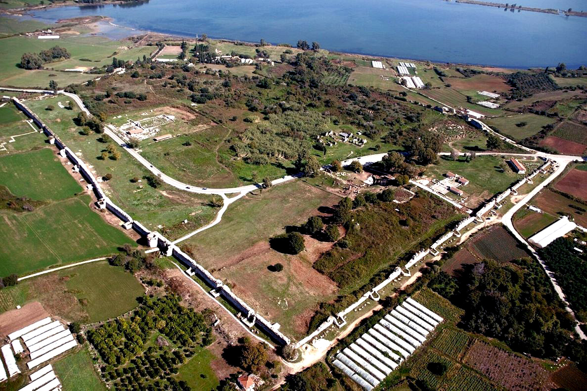
The Byzantine wall, which is newer and much smaller than the Roman one, is better preserved. The fortification has a trapezoid plan with a wall perimeter of 2,072m. The area covered is 280,000 sq.m., i.e. approximately 18% of the Roman Nicopolis.
In the Byzantine fortification, the eastern and northern parts were built on top of the pre-existing Roman wall, while the southern and western parts were built from the beginning, along the main streets of the urban layout of the Roman city. These “new” sides, the west (to the northwest) and the south (to the southwest) are by far the best preserved sides of the quadrilateral fortification (photos 1, 9, 12, 13). On the other two sides, many sections of the wall are preserved, but at a low height and not continuous.
The southern side of the Byzantine wall was erected along the main street of the roman city, leaving out the entire width of the street with its pavement, indicating that the street continued to be in use. The same was done on the western side which runs along another main street of the old city.
North and east, the Byzantine fortification made use of the Roman wall, which was completed in height.
On the south side of the wall (photos 12, 18) there are 12 towers of various shapes, placed at regular distances of 33 meters. In the SW and SE corner rises a circular tower (photo 14) and a polygonal respectively.
On the small sloping part of the southern side, up to its join with the Roman wall on the east side, are in a row two petal-shaped, one square and one polygonal tower (at a low height).
On the west side (photos 2, 3, 4) a different layout is followed: There are 16 towers, 11 rectangular in a row, 2 circular in the corners to the north and south, 2 petal-shaped on either side of the Western Gate and a circular one on the north side of a gate. The inter-tower space ranges from 26 to 40m.
It is clear that the southern and western parts of the wall belong to separate building phases. The facades of the western side show greater care in the wall construction and in some places have ceramic decoration. The western side is slightly newer and somewhat less elaborate.
On the eastern side, which is not so well preserved, the foundations of rectangular towers can be found and one of them is preserved to a great height. It is of similar construction to the towers of the western leg.
The thickness of the wall ranges from 2.45m up to 4.90m. The greatest thickness is usually observed on either side of the gates, as well as in the angular folds of its course, where it increases towards the inner front. The wall on the south and west sides is preserved to a considerable height (6 to 8 meters) and to a great length.
The northern side of the Byzantine fortification has not been systematically investigated and is covered by vegetation. Here the Roman wall has been used as a base, on which a later wall was built with extensive use of spolia from Roman buildings. On this side, to the east of the road, you can see the remains of the Roman wall (it is not clear if there was a Byzantine superstructure here) and a large triangular tower, dating back to early Byzantine times.
Regarding the gates of the Byzantine fortification, the main gate was the western one, known locally as “Arapoporta” (photos 5, 7, 8). Very close to it is a secondary gate. Another gate is preserved on the south side (photo 10). There are traces of a gate on the east side as well. Today, the asphalted road passes through the gate on the north side, but there is an old picture of it (photo 15).
Other monuments
In the archaeological site of Nicopolis there are many important monuments, such as:
The Odeion (where performances were held until 1997), the Roman theater, the Nymphaeum (two sanctuaries with cisterns), Thermae, the Augustus Monument.
As for Byzantine monuments, we have 6 Basilicas in Nicopolis, 4 of which (the one of Dumetius, the one of Alcison and two others) are within the Byzantine walls.
A very impressive construction was the aqueduct of Nicopolis with a length of 50 km from which many spots are preserved. The aqueduct starts from afar, near the village of Agios Georgios, north of Philippiada, where there is the best preserved part of it.
| First entry in Kastrologos: | October 2012 | Last update of info and text: | May 2023 | Last addition of photo/video: | May 2023 |
Sources
- Κωνσταντίνος Ζάχος, Αρχαιολογικόν Δελτίον, τεύχος 55/Β1 (2000) σελ.557-576
- Website ΟΔΥΣΣΕΥΣ - Greek Ministry of Culture - Νικόπολη στην Πρέβεζα
- Κωνσταντίνος Ζάχος, H οχύρωση και η πολεοδομική οργάνωση της ρωμαϊκής Νικόπολης: Νεότερα στοιχεία και παρατηρήσεις, Πρακτικά του Δευτέρου Διεθνούς Συμποσίου για τη Νικόπολη (11-15 Σεπτεμβρίου 2002), Ίδρυμα Άκτια Νικόπολις, Πρέβεζα 2007, Τόμος Ι, σελ. 273-276
- Νικόλαος Λάσκαρης, Νικόπολη-Το πέρασμα από τη Ρωμαϊκή στη Βυζαντινή εποχή (Μορφή και χαρακτήρας μιας πόλεως), Πρακτικά του πρώτου Διεθνούς Συμποσίου για τη Νικόπολη (23-29 Σεπτεμβρίου 1984), Ανάτυπο, Πρέβεζα 1987, σελ. 205-223
- Ιωάννα Ανδρέου, Τοπογραφικά και πολεοδομικά Νικόπολης , Πρακτικά του Δευτέρου Διεθνούς Συμποσίου για τη Νικόπολη (11-15 Σεπτεμβρίου 2002), Ίδρυμα Άκτια Νικόπολις, Πρέβεζα 2007, Τόμος Ι, σελ. 231-262
- Video by the user Aerial Views Greece Nikopolis
- Video by the user CHRIS.P-LifeAfterGravity Ancient Nikopolis - The Amazing Largest Ancient City in Greece
|
|
| Access |
|---|
| Approach to the monument: |
| On the road from Preveza to Igoumenitsa, 10 km north of Preveza |
| Entrance: |
| Ticket entrance to some parts. Limited hours. |


