

Xylokeriza, Corinth, Corinthia,Peloponnese
Venetian fortifications of Mt. Oneia


| Location: |
| At the northern slopes of Oneia mountains, between Xylokeriza and Loutra Oraias Elenis, south of Corinth |
| Region > Prefecture: |  |
| Peloponnese Corinthia | |
| Municipality > Town: | |
| City of Corinth • Xylokeriza | |
| Altitude: | |
| Elevation ≈ 265 m |
| Time of Construction | Origin | |
| early 18th cent. | VENETIAN |
|
| Castle Type | Condition | |
| Fortress |
In Ruins
|
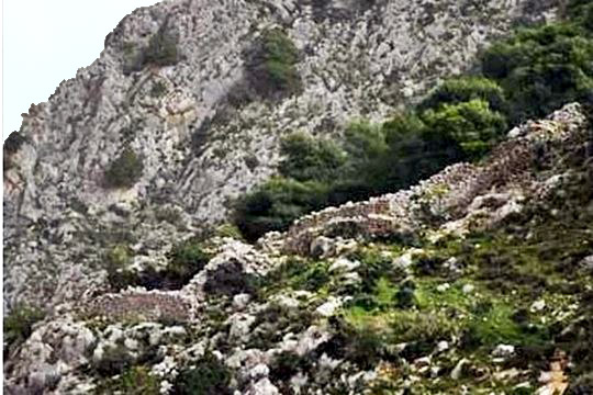
“Oneia mountain” is an elongated chain of hills south of the Isthmus of Corinth. The hills extend for about 8km on the axis east-west reaching the eastern coast of Peloponnese above the little port of “Loutra Oraias Elenis”.
At the northern slopes of these hills there are two small Venetian forts which are presented here together as one fortification. Close to each of these forts there is one fort from the Hellenistic period.
So, in total, there are four forts on Oneia: two Hellenistic forts and two, smaller, Venetian ones. Moreover, between the main fortifications, there are remains of other walls which date also from the Hellenistic period.
Location & Strategic Scope
Mt. Oneia is a natural fortification and a second line of defense after the Examillion wall against an invading enemy from the Isthmus.
The problem is that Oneia, despite its length (8km), has a relatively small mass. That means that it is not an insurmountable obstacle for a force that would prefer to avoid longer or better protected routes (like through Kechrees). Moreover, there are two passes through the hills: Stanotopi at the east and Maritsa at the center (see the map below). These passes are not easy but would not be a problem for a flexible force.
For this reason, each pass was protected by an ancient fort and later by a Venetian fort.
The two Venetian forts were closer to the northern entrance of the two passages (in relation to the ancient fortresses). The distance between them is ca. 1700m.

History
The two small Venetian fortresses on Oneia were built during the Second Venetian period of Peloponnese (1685-1715). Their purpose was to prevent the advancement of an Ottoman force coming from the Isthmus.
The time of their construction was the end of the 17th or, more probably, the beginning of the 18th century.
They were constructed of identical masonry. It is reasonable to assume that they were built at the same time and by the same work crews. Their construction was much simpler and humble compared to other imposing fortresses in Peloponnese of that period.
It seems that these forts never played a role in the defense of Moreas. We have no idea whether they were actually used to defend the Peloponnese at the time of the final Ottoman attack. Probably they were not, because their usefulness depended on the Venetians being able to hold the main lines of attack at the Hexamilion, the coastline near Kenchreai, and the Xeropotamos Valley. In July of 1715, the Ottomans, under the command of Ali Kumurgi, descended into the Corinthia with a force of 70,000 men, while the Venetians had only 8,000 soldiers. The Venetians placed their hopes in the local Greek population and elected to defend only five of the fortresses in the Peloponnese; the Venetian Senate ordered the dismantlement of the rest. Accordingly, the Venetians offered no resistance at the Hexamilion and, after a short siege, Acrocorinth surrendered on August 3.49 By August 11, the Ottomans were in the Argolid and the defense of Oneion was moot.
The absence of any findings in the two forts and the lack of military reports may indicate that the defenses were never used or manned after their construction. In any case, they were not used in later periods.
Structure, Fortification & Buildings
The Venetian fortifications on Mt.Oneia were constructed of identical masonry, with exterior walls of irregular blocks filled with rubble and mortar. The exterior blocks were roughly hewn on their outer surface to make a relatively smooth face. The outer surfaces were covered by a coat of mortar that has mostly disappeared but was presumably applied over the entire face. The exterior faces of the walls have a significant upward taper or battering, a characteristic of military construction in this period.
Each fortification complex is a barrier wall with a fighting platform along the interior, terminating in a rectangular tower In each case, the wall crosses the road through the pass relatively low on the mountain, about a third of the way to the top, at a point where the road itself changed course and the natural lay of the land made evasion difficult. The purpose of the tower was to block an evasion downhill, while permitting enfilading fire back up across the road.
Like the earlier Greek fortifications, the Venetian fortifications were apparently designed to be resupplied from the rear, presumably from the main Venetian power base south of the Isthmus, at Nafplion.
Stanotopi
At Stanotopi pass, the Venetian fortifications were originally made up of three bastions. The bastions at the ends were designed to block the roads. The bastion approximately in the center sits at a height above the other two. It is noteworthy that this fortification complex was built in the age of gunpowder, when an enemy could overcome any defense simply by placing artillery at a nearby higher elevation. The fortifications today are in relatively good condition, although a section of the wall above the eastern bastion has recently been bulldozed for construction of a forest road, while the western bastion has been completely destroyed by the modern quarry.
The eastern bastion is a three-sided fortification without a wall protecting its southwestern, upslope exposure. Its eastern wall runs for some 20 m parallel to the course of the ravine. This wall is pierced by three drains, which allow water accumulating inside the bastion to run out toward the ravine. At its southern end, it turns almost 90 degrees and runs some 15 m to the southwest. At its northern end, this wall also turns at 90 degrees and extends nearly 50 m uphill, also in a west/southwest direction. The wall of the bastion is preserved today to a maximum height of 2.62 m above the ground on the exterior (at the southeast corner). On the interior, there is a fighting platform ca. 1.45 m wide. The northeast and southeast corners of the eastern bastion are better made than the rest of the fortifications. They were constructed of headers and stretchers laid in alternating courses, a characteristic of the masonry in some contemporary Venetian castles such as the Palamidi at Nauplion.
The northern wall of the eastern bastion continues west up the hill in an approximately straight line and then turns to the northwest to the top of the ridge, where a well-built pentagonal bastion occupied the high point between the ravines. In the middle of the southwest side (the continuation of the main wall) is a doorway, ca. 1.50 m wide, leading into the bastion. The fighting platform is ca. 1.50 m wide on the northern face of the main wall, and it was ca. 0.50 m below the top of the wall.
Approximately 15 m west of the central bastion is a doorway through the wall, the same width as that in the bastion. On the southeastern side of the doorway a series of steps, parallel to the wall, provided access to the fighting platform on the interior.
From the central bastion, the fortification wall descends for about 100 m in a line that curves slightly to the north and reaches the point where the western ravine and a road undoubtedly once ran. Today the wall terminates abruptly here, cut by a modern road and an enormous quarry. Originally, however, the wall extended up the slope on the western side of the ravine for about 40 m, then turned north and again west-northwest until it reached a cliff. It is possible that the western end of the wall, which would have turned sharply to the east before ending at a large rock, served as another bastion with an open rear exposure.
Maritsa
The fort on the Maritsa pass displays many of the same characteristics as those at Stanotopi. They are located astride what must have been the main road into the pass, along the eastern side of the ravine, and they are relatively low on the side of the mountain, beginning at an elevation of 236m. The main defense is a rectangular tower,8.80✖11.20m on the exterior, built on a rock outcrop that adds to the elevation of the tower at a point where the original road must have made a turn along the side of the ravine. No rectangular blocks were used in the fortification, although the stones were roughly finished to make a relatively flat surface, especially on the exterior. The stones used seem to have been ca. 0.30m in length and 0.20m in height, but many larger stones were also employed. Both the exterior and the interior of the walls were originally covered with stucco. The interior face of the walls is vertical, but the outer face is battered.
The walls of the tower vary between 0.90 and 1.15m thick. They are preserved as much as 3m above the lowest level of the bedrock inside the tower, although there are places where the bedrock is actually higher than the preserved tops of the walls. Inside the tower is a fighting platform, 1.00-1.25m wide, with its original surface preserved in several places. In keeping with the declining level of the bedrock outside the tower, the fighting platform of the north and south walls descends noticeably from east to west, creating a ramplike effect. Interestingly, there seems not to have been any doorway into the tower; instead, access must have been from the level of the fighting platform of the curtain wall behind the tower.
To the southeast, the mountainous terrain directly behind the tower rises precipitously. The original roadway presumably was located just be hind the tower and was blocked by the wall running uphill from the tower. This wall went first in a southeasterly direction for ca. 10.50m, and then more directly east for about 50m before reaching a huge outcrop of rock. This curtain wall was, like the walls of the tower, 1.10m wide; it was attached to a fighting platform 1.30m wide. The original surface of the platform is relatively well preserved at many points and is sometimes even higher than the curtain wall itself. The surface of the ground inside the fortifications is very irregular.
Over the total length of the wall, ca. 60.50m, the elevation rises by 21m, creating an average slope of about 35%. In order to allow the soldiers to go up and down this slope with relative ease, a series of steps were constructed at points of rapid rise, and these survive in the fighting platform today. The fortification walls are not preserved to their original height, but they stand about 2.30m above the surface on the exterior at the highest preserved point, just beyond the jog in the wall to the east. At a point midway along the eastward stretch of wall, another structure seems to have been built flush against the fighting platform on the interior of the wall. This is not well enough preserved to allow us to be certain of its function, but it may have been a stairway up to the level of the fighting platform from the ground below.
| First entry in Kastrologos: | November 2016 |
Sources
- Caraher W.R. – GregoryT.E., “Fortifications of Mount Oneion, Corinthia,” Hesperia, 75:3 (2006), 327 – 356.
- Website ecastles.culture - Όνεια όρη, κάστρο
|
|
| Access |
|---|
| Entrance: |
| Free access |


