

Pente Ekklissies, Souli, Thesprotia,Epirus
Castle of Osdina


| Location: |
| North of the village Pente Ekklissies in Thesprotia, Epirus |
| Region > Prefecture: |  |
| Epirus Thesprotia | |
| Municipality > Town: | |
| City of Souli • Pente Ekklissies | |
| Altitude: | |
|
Elevation ≈ 140 m (Relative Height≈70 m) |
| Time of Construction | Origin | |
| Mid-Byzantine period | BYZANTINE |
|
| Castle Type | Condition | |
| Medieval Settlement |
Rather Poor
|
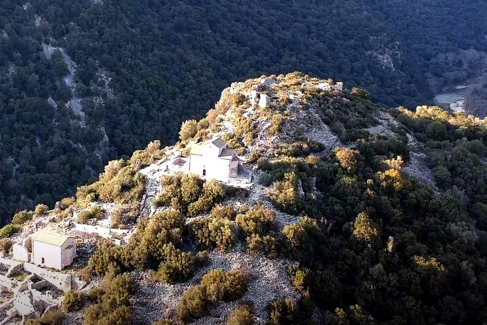
The ruins of a medieval town on a hill next to the village of Pente Ekklissies ("five churches") overlooking a beautiful gorge of Kalamas river. The town was founded during the Mid-Byzantine period at the location of the ancient acropolis of Osdina.
History
The ancient settlement was destroyed in 167 A.D., most probably by the Romans. During the mid-Byzantine period, repairs were undertaken on the walls and the settlement seems to have increased in prominence.
New churches were erected during the 16th century, when the bridges were also repaired. The settlement was abandoned in the 18th century, in a period when the Ottomans were forcing the population to convert to Islam.
Structure, Fortification & Buildings
The ancient pseudo-isodomic wall surrounds the settlement on all sides. Two gates are still visible. An ancient bridge and four moats have been discovered near the settlement, and may date from the Hellenistic period.
The Byzantine village was more extensive than the ancient settlement in both land and population. The limestone wall is 1.5m thick. Houses are one or two storied, with two to three rooms on either storey. Both dry earth and mortar were employed in the masonry.
The village centre was situated between the churches of the Panagia and the Taxiarches. Nine churches and one monastery have been found at Uzdina to date. The most important of the churches are those of Hagios Athanasios, the Taxiarches, and the Panagia. The first of these was originally a cruciform church, but today, after many interventions, has the form of a single-cell structure. The Taxiarches church dates from the 16th century and is a vaulted single-cell structure with a substantial use of brick in the east wall. Wall-paintings therein date from the 17th century. The small church of the Dormition of the Virgin is cruciform with a three-sided apse. Two inscriptions in stone relate that the church was erected in 1609, and that it was initially vaulted prior to its transformation into a cruciform structure in 1610.
| First entry in Kastrologos: | March 2013 |
Sources
- Website Οδηγός Περιφέρειας Ηπείρου - Κάστρο Οσδίνας
- M. Passiakos, photos from Panoramio - «Κοίμηση της Θεοτόκου»
- Dim. Konstantios , Published in στο Δελτίον της ΧΡΙΣΤΙΑΝΙΚΗΣ ΑΡΧΑΙΟΛΟΓΙΚΗΣ ΕΤΑΙΡΕΙΑΣ, “UZDINA OF THESPROTIA: HISTORY, URBAN DEVELOPMENT, AND MONUMENTS OF AN ANCIENT AND MEDIEVAL SETTLEMENT”, Δελτίον XAE 15 (1989-1990), Περίοδος Δ'• Σελ. 89-104
|
|
| Access |
|---|
| Approach to the monument: |
| The castle is on a hill next to the village Pente Ekklissies, on the 73th km of NR Ioannina-Igoumenitsa. |
| Entrance: |
| ? |


