

Platiana, Andritsaina-Krestena, Elis,West Greece
Castle of Paliakoumpa
or Castle of Acumba or Accomba or Le Combe
1
2 / 16

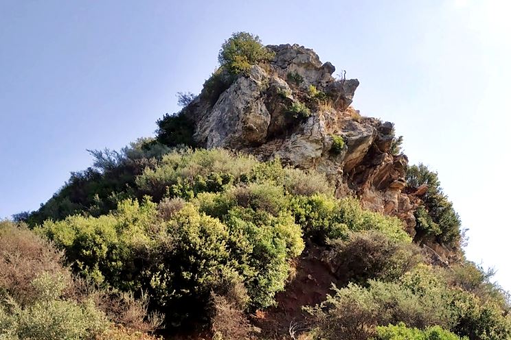
western rock-tower / photo: Amfitreidis, 2020
3 / 16

Wall of acropolis / photo: Amfitreidis, 2020
4 / 16

South wall / photo: Amfitreidis, 2020
5 / 16

South wall / photo: Amfitreidis, 2020
6 / 16

Internal partition wall / photo: Amfitreidis, 2020
7 / 16

North wall / photo: Amfitreidis, 2020
8 / 16

Settlement ruins / photo: Amfitreidis, 2020
9 / 16

Southern non-walled side / photo: Amfitreidis, 2020
10 / 16

western rock-tower /photo: Amfitreidis, 2020
11 / 16

western rock-tower /photo: Amfitreidis, 2020
12 / 16

Kendrick Pritchett,1989 – plate 119
13 / 16

Kendrick Pritchett,1989 – plate 117,118
14 / 16

Kendrick Pritchett,1989 – plate 116
15 / 16

Tsemperoula bridge / photo: Amfitreidis, 2020
16 / 16

View of the rock-tower from west / photo: Amfitreidis, 2020

THE END
| Location: |
| On a hill 2 km east of the village Platiana of Elis, eastern Peloponnese |
| Region > Prefecture: |  |
| West Greece Elis | |
| Municipality > Town: | |
| City of Andritsaina-Krestena • Platiana | |
| Altitude: | |
|
Elevation ≈ 460 m (Relative Height≈50 m) |
| Time of Construction | Origin | |
| probabbly 13th cent. | FRANKISH |
|
| Castle Type | Condition | |
| Castle Ruins |
In Ruins
|
A castle and a small medieval settlement 1km east of the village Platiana in Elis.
Location & Strategic Scope
The castle is close (1km to the east), to the acropolis of Platiana, an archaeological site of Hellenistic origin which was not in use in the Middle Ages. The location of Paliakoumpa commands two main old main roads, the Platiana-Vresto Zourtsa (Kato Phigaleia) road and the Platiana-Longo-Fanari-Andritsaina road. It has also a good view of the valley of Alfeios river.
The Name of the Castle
The castle has been identified as Castello della Cumba of the fief lists of 1377, La Combe of the 1391 list, Acumba of the Venetian catalog of 1467 and Accomba of the map of Nicolas de Fer (1705).
The identification and the name “kastro of Paliakoumpa” was proposed by Meyer (1957) who noticed that the local name of the hilly area south of Platiana is “Paliakoumpa”, which could derive from the various frankish versions of the name of the castle. The name cumba or comba comes probably from a medieval Spanish or Italian word meaning hump. Indeed, the shape of the hill above Platiana looks like a hump.
History
It is not certain which was the ancient city west of the castle. It could have been the ancient Typaneai or Ypana (two cities mentioned by Polybius) or Aipy (mentioned by Homer). Most probably, it was Ypana according to evidence provided by Meyer (1957). Apparently, the city was deserted by the end of the Hellenistic period.
The medieval settlement was created later, in the middle Byzantine or the Frankish era. We do not know when exactly.
Nothing is known about the medieval history of the castle. The only records about it is in the various Frankish lists of fiefs. In 1377, it belonged to the Prince of Achaea. In 1391, it was a property of Moyne de Pollay, who most probably never actually owned the place. At that period, the Principality was under the rule of the Navarrese company of mercenaries, while the Frankish Contenders of the throne (Amedee de Savoie and Charles III of Naples) granted titles and properties in the Morea which had no real value.
From the beginning of the 15th century, Paliacumpa must have been in the hands of the Byzantines of the Despotate of Mystras. The Venetian census of 1467 notes the castle as an Ottoman possession. The settlement must have been abandoned in the beginning of Tourkokratia, since there are no findings or records from that period. The fact that Accomba is mentioned in a 18th century map could mean that the French cartographer copied an old Frankish map.
Meyer notes that a copper coin was found there (tomessello, Venetian coin of Doge Antonio Venieri 1382-1400). This is the only known medieval finding from the site (apart from the ruins of the buildings).
Structure, Fortification & Buildings
The perimeter of the castle is about 350m. The max length, on the west–east axis, is 140m, while the width is 35m. This was a really narrow settlement mirroring the equally narrow acropolis of Platiana.
The castle consists of 3 levels. The higher level is on the western side and is not fortified. The middle and lower levels are fortified and contain ruins of houses. A large part of the southern side is not fortified because of the rough terrain. The rest of the perimeter is fortified with a wall preserved to a maximum height of 2m and mostly covered by growth.
The entrance must have been on the narrow eastern side. The acropolis is a small plateau littered with piles of stones but without signs of fortification. At its west corner a steep rock has been partially carved and must have functioned as a defensive natural tower.

1=> the castle, 2=>village Platiana 3=> ancient Ypana/Platiana acropolis, 4=> Tsemperoula bridge
| First entry in Kastrologos: | January 2017 |
Sources
- Research, photographs (+layout) and info by Sakis Lemonakis and his blog ΑΜΦΙΤΡΕΙΔΗΣ
- Konstantinos Kourelis, “MONUMENTS OF RURAL ARCHAEOLOGY MEDIEVAL SETTLEMENTS ΙΝ ΤΗΕ NORTHWESTERN PELOPONNESE”, Presented to the Faculties of the University of Pennsylvania in Partial Fulfillment of the Requirements for the Degree of Doctor of Philosophy, pag.339, 2003
- Antoine Bon, 1969, La Morée franque. Recherches historiques, topographiques et archéologiques sur la principauté d'Achaïe (1205-1430), Editions de Boccard, pag.391
- Meyer, Emst, Neue Peloponnesische Wαnderungen Bern, 1957, pag. 36-39.
- Ioannis Sphikopoulos, Τα µεσαιωνικά κάστρα του Μορηά , Athens,1987, pag. 307-308
- Ιστοσελίδα Αριστομένης ο Μεσσήνιος - άστρο Παλιακούμπα, Τριφυλία
- W. Kendrick Pritchett: Studies in Greek Topography, Part VI, University of California Press, 1989, page.54- 58
|
|
| Access |
|---|
| Approach to the monument: |
| From the cemetery of Platiana a dirt road leads after 1100m to a point where we leave the car. The castle is to the south and we reach after a 15 min hike. |
| Entrance: |
| Free access |


