

Tripotama, Kalavryta, Achaea,West Greece
Castle of Psophida
or Ancient Psophis or Castle of Tripotapa


| Location: |
| On a hill above the village Tripotama of Achaea in northwestern Peloponnese |
| Region > Prefecture: |  |
| West Greece Achaea | |
| Municipality > Town: | |
| City of Kalavryta • Tripotama | |
| Altitude: | |
|
Elevation ≈ 695 m (Relative Height≈140 m) |
| Time of Construction | Origin | |
| Antiquity | ANCIENT |
|
| Castle Type | Condition | |
| Ancient City |
In Ruins
|
Psophis was an ancient city-state, the acropolis of which was used as a medieval castle by the Franks and the Byzantines between the 13th and 16th centuries.
The medieval name of the place was Tripotama (meaning 3 rivers) because there is the conjunction of the river Erymanthos with its two tributaries Aroanios and Siraios.
Also, Tripotama lies on the joint point of the 3 prefectures of Arcadia, Eleia and Achaea.
History
The ancient Psophis was destroyed by Alarich in 398 AD.
In the Middle Ages, the first textual reference for Tripotama comes from the Aragonese version of the Chronίcle of the Morea, mentioning Philip of Taranto’s takeover from the Greeks in 1306, and its reconquest by the Greeks in 1509. The “Greeks” in this case were the Byzantines of the Despotate of Mystras.
It is not known if the medieval fortification was initially built by the Franks or the Byzantines. Probably, the latter because if a Frankish castle pre-existed, the story of its conquest by the Greeks would be mentioned somewhere. Obviously the Byzantines penetrating into Frankish land found the ancient acropolis unprotected and unexploited and created a fort to obtain a stronghold deep into enemy territory.
Structure, Fortification & Buildings
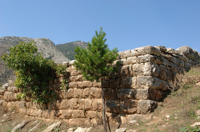
Only a few ruins remain from the castle. They include a fortress with two keeps, repairs in the wall circuit and houses. The acropolis consists of a long plateau sloping to the south about 160 m above the elevation of the street.
Two unattached medieval towers stand in ruin on the north side of the keep. The larger of the two, on the west, retains traces of associated cistern.It is of mixed stone, tile and mortar construction and survives to over 2 m high. The smaller tower on the east is of the same construction.
Το the south of the towers, the remains of a single isle chapel have been excavated by the Archaeological Service. The ancient acropolis wall survives on the northwest side including one attached ancient tower. The east, north and south sides of the fortification contain mortar and seem to be of medieval construction, probably a medieval repair phase. On the south side of the wall the medieval additions are visible over the ancient courses. Maximum width is 2 m and maximum surviving height is 2 m.
West of the acropolis about 30 medieval houses of non-mortar wall construction survive.
Well beyond the acropolis to the southeast, a monastery dedicated to the Dormition is enclosed by a rectangular wall. The monastery was founded in 1825 and destroyed by Ibrahim pasha in 1826. It was used again as a church and school after the end of the Greek War of Independence but it is reported destroyed in 1890. So the fortified wall we see today is a relatively modern construction.
| First entry in Kastrologos: | March 2016 |
Sources
- Konstantinos Kourelis, “MONUMENTS OF RURAL ARCHAEOLOGY MEDIEVAL SETTLEMENTS ΙΝ ΤΗΕ NORTHWESTERN PELOPONNESE”, Presented to the Faculties of the University of Pennsylvania in Partial Fulfillment of the Requirements for the Degree of Doctor of Philosophy, 2003, pp.373
- Antoine Bon, 1969, La Morée franque. Recherches historiques, topographiques et archéologiques sur la principauté d'Achaïe (1205-1430), Editions de Boccard, pp.402,662
- Website Ερύμανθος Κοινωφελής Εργασία - Αρχαία Ψωφίδα (Τριπόταμα)
- Website Exploring Greece - Acropolis of Ancient Psofida
- ΑΡΧΑΙΟΛΟΓΙΚΟΝ ΔΕΛΤΙΟΝ, τόμος 53 (1998), τεύχος Β1, σελ.307
|
|
| Access |
|---|
| Entrance: |
| Free access |


