

Sidirokastro, Sintiki, Serres,Central Macedonia
Sidirokastro Castle


| Location: |
| Sidirokastro, Central Macedonia |
| Region > Prefecture: |  |
| Central Macedonia Serres | |
| Municipality > Town: | |
| City of Sintiki • Sidirokastro | |
| Altitude: | |
|
Elevation ≈ 155 m (Relative Height≈80 m) |
| Time of Construction | Origin | |
| early 14th cent. | Late-BYZANTINE |
|
| Castle Type | Condition | |
| Castle |
Rather Poor
|
A byzantine castle on a 155m hill above the town of Sidirokastro in Macedonia.
It is also known as Issari Fortress from the Turkish name of the town “Demir Hisar” meaning iron castle. 'Sidirokastro' means the same.
History
In the past, the prevailing theory was that the castle of Sidirokastro was identified with Herakleia Sintiki, a Macedonian and Roman city of Thrace. But the ruins of this ancient city were found in 2002 a little further north, on Strymon river, in Bulgaria. So Sidirokastro is not Herakleia Sintiki and is not currently identified with any other place mentioned by historical sources before the 14th century. So, finally, we have no reports that there was a castle there from the 6th century (as believed before) or during the Middle Byzantine period.
The castle was built at the beginning of the 14th century, during the reign of Andronikos III Palaiologos (1328–1351). Ioannis Kantakouzinos mentions that the castle was named Sidirokastro (meaning “Iron Castle”) because of its strong walls and its formidable fortification.
The Iron Castle is mentioned in the middle of the 17th century by the Turkish traveler Evliyas Celebis and by Hatzis Kalfas who found it abandoned. At the same time, a flourishing town, known in texts of the 17th-19th centuries, by the name of Demir Hissar, had already developed at the foot of the hill and on the banks of the Krusovitis River.
Outside the walls, a Hellenistic tomb survives –with temple-shaped facade– carved into the rock, whose chamber decorated with Byzantine frescoes has been converted into the chapel of Agios Dimitrios. Other carved tombs in the area, as well as occasional finds from Roman times inside and outside the castle, confirm that there was a settlement in this location during the Hellenistic, Roman and early Byzantine periods. Inhabitation during the Middle Byzantine period is not confirmed. Probably due to barbaric raids (Huns, Goths, Slavs, etc.) the settlement was abandoned between the 4th and 6th centuries AD, and later, during the late Byzantine period, the area was inhabited again, partly, due to the presence of the castle.
Structure, Fortification & Buildings
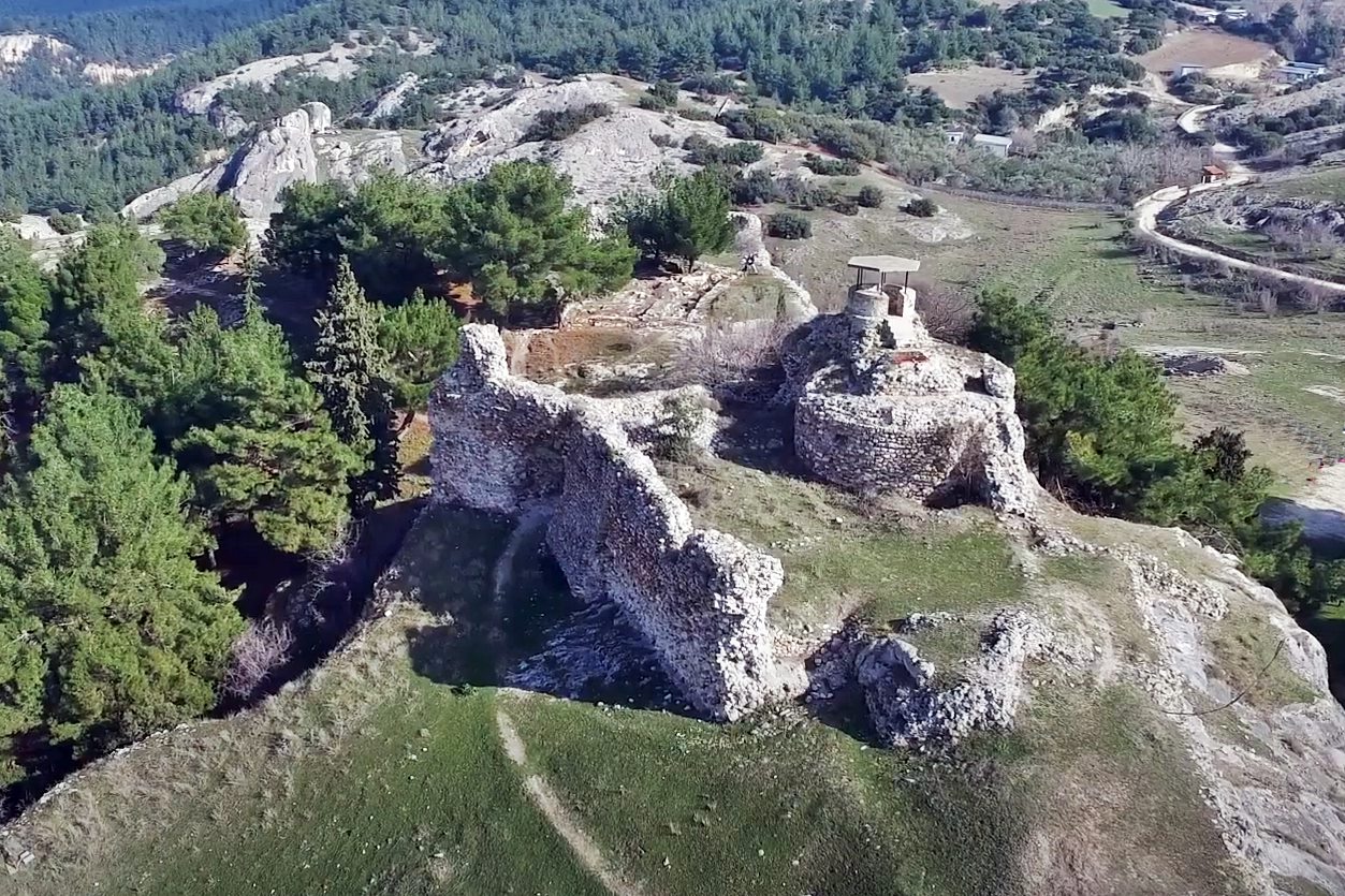
The castle is located on the southwest side of a rocky hill (named “Issari”) with excellent natural protection. The position can control a large part of the Serrai plain, the valley of the Strymon river, and also the access to south-west Bulgaria.
The castle has a strange irregular shape that follows the terrain (see layout). Its total area is about 44,000 sq.m., while the perimeter of the walls exceeded 1100 meters.
The fortress had an inner and outer fortified enclosure reinforced with round and square towers. Two entrances have been found, both on the south side (one is a secondary gate, while the main gate is the one shown in most photographs above).
The masonry consists of river stones (from the Krousovitis river apparently), with bricks among them and with the use of lime mortar as a binding material. At the bottom of the walls there are rows of well shaped stones that belong to ancient buildings that may have existed before on the hill.
Only a small part of the walls survives today. On the eastern side (photos 4,5) the walls are kept at a height of up to 8 meters without preserving the ramparts, which means that the original height was greater.
In the inner enclosure, near the gate, there is a large circular tank 5.40m deep. and 4.05-4.20 m in diameter. Its capacity was about 60 cubic meters! This tank was at the base of a large round tower with a diameter of 9.5 m. of which only traces survive. To this tower belongs the solid mass of a hemispherical dome, which is located in front of the adjacent gate of the castle and which is locally known as the “cup of the Bulgaroktonos”.
| First entry in Kastrologos: | October 2012 | Last update of info and text: | September 2022 | Last addition of photo/video: | September 2022 |
Sources
- Video by the user Nikos Tsar Το Βυζαντινό Κάστρο στο Σιδηρόκαστρο Σερρών (also source of photos 1,5,11,12.)
- Video by the user Hellenic Observation Center Σιδηρόκαστρο - ΣΕΡΡΕΣ
- Χ. Μπακιρτζής, ΑΡΧΑΙΟΛΟΓΙΚΟΝ ΔΕΛΤΙΟΝ, τεύχος 40 (1985), σελ.280-281
|
|
| Access |
|---|
| Approach to the monument: |
| - |
| Entrance: |
| Free entrance |


