

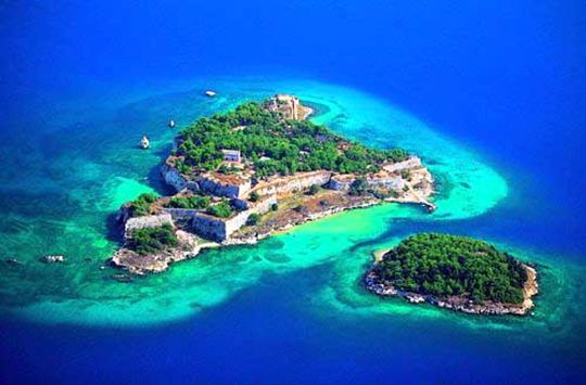
Souda islet, Chania, Crete
Souda Fortress


| Location: |
| Isle of Souda, Souda gulf, near Chania, Crete |
| Region > Prefecture: |  |
| Crete Chania | |
| Municipality > Town: | |
| City of Chania • Souda islet | |
| Altitude: | |
| Elevation ≈ 5 m |
| Time of Construction | Origin | |
| 1573 | VENETIAN |
|
| Castle Type | Condition | |
| Coastal Fortress |
Average
|
Souda is the name of the small island that stands like a guard in the entrance of the gulf of Souda. On this island the Venetians built a castle in the 16th century which later, when the Turks came, was proved one of the most enduring fortifications in Greece.
The name of the gulf and of the island derive from the Latin sudes meaning "narrow pass".
History
There was a fortress on the little island already in the 14th century. The constructions of the Venetian castle started much later, in 1573, by the Venetians, in an effort to reinforce the defense of the port of Souda and to control the Gulf entrance.
The architect and supervisor of the constructions was Latino Orsini. The works proceeded very fast and within a year, the first canons were placed. In the years that followed, until the Turkish invasion in 1645, conservation and other complementary works for the fortification's improvement were taking place. During this time is dated the1585 construction and the central temple, which is well preserved until today. The temple hosted clergymen of the St. Augustine order, since an Augustinian monastery pre-existed on the islet.
After the occupation of the city of Chania from the Turkish army in 1646, the Suda fortress was attacked. However, the few armed defenders of fortress were able to save it. After the occupation of Handakas (today Heraklion) in 1669, the islet remained under Venetian possession after negotiations and agreements. The islet remained in Venetian possession until September 27, 1715, when it was finally surrendered to the Turkish army after a long siege and heroic resistance that lasted 72 days.
The Turks occupied the islet until 1898 when the Turkish forces departed from Crete. During the period of Turkish occupation on the islet, no major changes or addition were made in the fortress, except the transformation of the central temple to a mosque, dedicated to Sultan Gazi Ahmet Han.
The islet of Souda is connected with the Cretan history and the battles of the Cretan people for freedom, as it played a crucial role during battles and became a refuge for the revolutionaries throughout the Turkish occupation, when the islet was in Venetian hands.
On this islet, the Greek flag was raised for the very first time on February 1, 1913 (before the official unification of Crete with Greece). After World War 2, the islet is in the jurisdiction of the Greek Armed Forces, in the framework of a wider plan of defense of the port. In 1966, the Greek Navy planted trees on the islet, where before there was a complete lack of plantation. Souda is still used today as a naval base. For this reason the base of Souda not allowed visitors and take pictures.
After many years of systematic efforts, the request of the local community was satisfied and the islet of Souda was free of military supervision. In the end of spring 2007, visitors were allowed on the islet twice a week, with the cooperation of the naval yard of Crete, the 28th Commission of Byzantine Antiquities and the municipality of Souda. Transportation is available from the port of Souda.
Structure, Fortification & Buildings
The castle was an example of excellent fortification work, taking advantage of the islet's morphology. Its strategic construction provided smart solutions to possible threats from the mainland and the sea. According to records, the armament of the fort in 1630 consisted of 44 guns of various calibers and 9185 balls. The walls surrounded the whole area of the island of Souda. In the northern part was the Martinengo and the Michiel bastion. Between them, a small door lead to the lower part of the island of Souda. There was a cemetery, a sub-bastion called Mocenigo and a water tank.
On the east side there were barracks and, in front of them, were three tanks, warehouses, the garden and the church of Holy Mary, La Madonnina. On the southwest side was the Orsino bastion and the gate of the fortress. On the west side, there were three tanks and ammunition depots, an exercise field and a windmill. Apart from these, there was a hospital, prison and accommodation for visitors.
| First entry in Kastrologos: | October 2012 |
Sources
- Website cretanbeaches.com Souda islet
- Ιωάννης Κακουδάκης «Τρία Κάστρα της Κρήτης» από την ιστοσελίδα ΕΚΔΟΣΕΙΣ ΚΕΡΑΤΟΣ - Tρία κάστρα της Κρήτης
|
|
| Access |
|---|
| Approach to the monument: |
| Access by boat only. It is allowed only twice a week. |
| Entrance: |
| ? |


