

Paradeisos, Nestos, Kavala,East Macedonia & Thrace
Topeiros


| Location: |
| Paradeisos village, on the old NR to Xanthi, 500m before Nestos river bridge |
| Region > Prefecture: |  |
| East Macedonia & Thrace Kavala | |
| Municipality > Town: | |
| City of Nestos • Paradeisos | |
| Altitude: | |
|
Elevation ≈ 40 m (Relative Height≈0 m) |
| Time of Construction | Origin | |
| 1st century | BYZANTINE |
|
| Castle Type | Condition | |
| Byzantine City |
In Ruins
|
Topeiros was founded in the 1st century AD, at the time of the Roman emperor Augustus in a location of an ancient Thracian city at the junction of Nestos river with Via Egnatia.
The city is mentioned by Prokopios.
The walls were repaired in the 6th century after their destruction in a raid by Slavs in 549 AD. However it seems that the town never recovered after this.It was abandoned after 812 when the king of the Bulgars Krumus pillaged many cities and fortresses in Thrace.
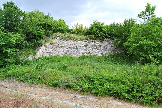
Today only some parts of the walls remain.
| First entry in Kastrologos: | May 2013 |
Sources
- Procopius, De aedificiis 4, 11, 14-17
- Procopius, Υπέρ των πολέμων 7, 38, 9-18
- Strabo, Γεωγραφικά, 7α, 1.44
- Ιεροκλής, Συνέκδημος 634.7-9
- Kωνσταντίνος Πορφυρογέννητος, Περί Θεμάτων 2.37
|
|
| Access |
|---|
| Approach to the monument: |
| The castle is on the road, on the old NR Kavala-Xanthi, after the village of Paradeisos, 500km before Nestos river. There is a road sign indicating the location (otherwise, it is easy to be missed). |
| Entrance: |
| The castle is not protected, but the access is impossible due to the thick vegetation. Only parts of the outer walls are visible. |
| Other castles around |
|---|
| Fortress of Avgo |
| Fortress of Kalyva |
| Fortress of Komnina |
| Mesegouni Fortress |
| Fortress of Petropigi |
| Polystylon |
| Xanthi Castle |