

Potamia, Naxos, Cyclades,South Aegean
Apano Kastro of Naxos
or Kastro of Tragea or Castle of Koutsocheradou


| Location: |
| On a hill near Potamia, Tragea area, Naxos island |
| Region > Prefecture: |  |
| South Aegean Cyclades | |
| Municipality > Town: | |
| City of Naxos • Potamia | |
| Altitude: | |
|
Elevation ≈ 420 m (Relative Height≈230 m) |
| Time of Construction | Origin | |
| end of 14th cent. | VENETIAN |
|
| Castle Type | Condition | |
| Castle |
In Ruins
|
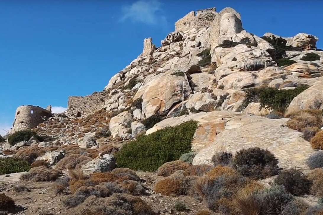
In the Middle Ages, Apano Kastro (or “Upper Castle” ) was the strongest castle of Naxos. It was fortified since antiquity, but the ruins we see today are mostly from the 13th-14th century, when it was reconstructed by the Venetian rulers of the island.
Near the village of Potamia you will meet a path that leads to Apano Kastro.The path isn’t easy but it is worth the time and effort.
The impressive castle stands at an altitude of 420m while it has an excellent view to the valley of Tragaia in the east and the village of Potamia in the west side. Its location proves that it was a landmark for Central Naxos. Near its walls are built the Byzantine chapels of Virgin Mary Kastriani and Saint George. In the region there are also two ancient cemeteries.
The locals call the place “Slaves” probably because of the raids of pirates that captured them. It is also known as “Koutsocherado” once again due to the massacre of its residents by the pirates.
History
The castle was first built around 375 BC when the Athenian general Chabrias defeated the Spartan fleet and Naxos returned to the Athenian alliance.
In the Byzantine years it was rebuilt to protect the inhabitants of the fertile Tragaia valley from the Saracen pirates. The Byzantines built cisterns and food stores in Apano Castle to withstand multi-day sieges.
According to tradition, it took its final form at the beginning of the 13th century, after 1207, by the Duke of the Cyclades Markos Sanoudos.
However, according to recent archaeological findings, this version does not seem to be correct. It is possible that Markos Sanoudos made some repairs, but the final form of the Apano Kastro took shape probably at the end of the 14th century. The reason for the (re)construction was the need for protection from the attacks of the Turks, as Sultan Bayezid in 1390 built a fleet of 60 ships which was unleashed for plundering in the Aegean (until then the Ottomans were not threatening at sea). At that time, therefore, after 1390, the castle was built.
In addition, it is believed that the castle was renovated around 1500, at which time another series of walls was added on its southern side, which was strengthened by the two circular towers-bastions that have survived today, which brought an innovation for that time : they had cannon holes.
The above hypothesis (about the renovation) is also supported by the historical testimonies regarding the efforts made to strengthen the defense of the island at the end of the 15th and the beginning of the 16th century by the temporary Venetian administration (1494-1500) under Duke Francisco III (1500-1511), under the authority of the Republic of Venice.
The castle was besieged several times but held out. This is where Angelos Sanoudos organized his defense in 1620 to face the rebellion of the inhabitants of Tragaia. In 1537, the Turkish admiral and pirate Barbarossa, who had plundered the entire Aegean that year, failed to capture it. However, Barbarossa finally occupied the island after the Venetian duke Ioannis IV Crispo handed over the keys to the castle of Chora.
Only the notorious French corsair Hugues de Crevelliers managed to capture Apano Kastro in 1678.
Structure, Fortification & Buildings
The Apano Castle was used in various periods from antiquity to the Venetian rule. We can see traces of walls, battlements, “palaces” and cisterns. In SE foothills, at the Alonakia location, there is a cemetery from the Geometric era (9th - 8th century BC).
At the entrance to the castle stands a Paleolithic menir 3 meters high.
The castle had two fortified enclosures, an outer lower one and an inner one at the top of the hill.
The outer wall enclosed the base of the hill, where parts of the wall and a tower survive today. In periods of raids, the people gathered behind the wall of the first fortification, which, however, was not inhabited in periods of peace. That is why, apart from several churches that are now in ruins (Agios Ioannis, Agios Georgios, Metamorfosi, Panagia Kastriani, etc.), no remains of other buildings have been found.
The second line of fortification was located at the top of the hill and was surrounded by steep slopes and walls. Here was the citadel of the castle.
The citadel of Apano Kastro is small with an area less than 3,000 sq.m. and perimeter of walls 250m. The castle in total covers an area of 14,000 sq.m.
In the lower part of the Apano Castle, two circular towers-bastions are preserved, one in good condition with a diameter of 9 meters and the other half-demolished. The canon doors of these bastions form semicircular niches, are similar to those of some castles of the Knights of St John in the Dodecanese. It is clear that these towers belong to the early era of gun powder and are younger than the rest of the castle which is more, so to speak, “medieval”.
At the top of the hill of Apano Kastro, where most of the buildings are located, dominate the ruins of a basilica, as well as another important building, which according to local tradition was the palace of the Duke or of the “Vasilissa” (=queen), which was the keep (donjon) of the castle and the command center. The buildings in question on the top of the hill were protected by the inner wall, which is double with a height of 9 meters. For the constructions in the citadel of Apano Kastro, ancient material was used in second or third use from ancient or even Byzantine buildings.
On the western side, the outer wall followed the course of the squared boulders of the Pelasgian wall. To the east, at the steepest point of the castle, stands a platform called the “Balcony of the Queen” and which was probably the outermost part of the palace, inside which a vaulted cistern is preserved.
The hill had water sources low down, on the eastern and western foothills, as well as a number of cisterns within the walls that are easily distinguished from the rest of the buildings as they are coated with kurasan. So the castle had sufficient water and this was an important defensive advantage.
The small surface of the upper level of the Apano Castle and the absence of buildings that could be characterized as houses, leads us to the conclusion that the castle did not host any permanent settlement but was more of a military fortress and a refuge for the population in times of danger.
However, at some time, perhaps from the 16th century and later, a settlement called “Goulas” was created on the hillside, some of whose houses must logically have been inside the castle. Much later, in the 18th century, there is evidence of the existence of a “Bourgos”, a fortified quarter on the eastern side of the hill.
It does not appear that any further work was done on the castle after the additions of 1500. But it certainly served as a refuge several times in the following centuries.
| First entry in Kastrologos: | October 2012 | Last update of info and text: | April 2024 | Last addition of photo/video: | April 2024 |
Sources
- Website thisisnaxos - Upper Castle
- ΚΑΛΑΒΡΟΣ ΠΑΝΑΓΙΩΤΗΣ, ΑΝΔΡΕΑΚΟΣ ΕΥΣΤΑΘΙΟΣ, Πτυχιακή Εργασία: Ενετικές Οχυρώσεις στη Νάξο, ΤΕΙ Πειραιά, Αθήνα 2006
- Photos 15,16 Triantafyllos Adamakopoulos - topoGuide.gr
- Αθανάσιος Δ. Κωτσάκης, «Η διαμόρφωση του πολιτισμικού τοπίου της νήσου Νάξου από το 1204 έως και την ίδρυση του Ελληνικού Κράτους», διδακτορική διατριβή, Πανεπιστήμιο Πελοποννήσου, Καλαμάτα, 2013, σελ.228,233
|
|
| Access |
|---|
| Approach to the monument: |
| There is a difficult path to the castle from Potamia. You reach the castle after 1 hour. |
| Entrance: |
| Free entrance |


