

Styra, Karystos, Euboea,Central Greece
Castle of Armena


| Location: |
| On Agios Nikolaos or Daikofti summit of mount Kliosi, above Styra town in S.Evia |
| Region > Prefecture: |  |
| Central Greece Euboea | |
| Municipality > Town: | |
| City of Karystos • Styra | |
| Altitude: | |
| Elevation ≈ 600 m |
| Time of Construction | Origin | |
| Various periods | ANCIENT |
|
| Castle Type | Condition | |
| Ancient City |
In Ruins
|
The castle of Armena or Larmena is an ancient castle which remained in use until the first centuries of the Turkish occupation
Location & Strategic Scope
The fortress is near the rocky summit Diakofti or Agios Nikolaos of mount Kliosi SE of the town Styra of Euboea. Enjoying a panoramic view over the whole region as well as Attica, the fortress was situated at a strategic location controlling the Eretrian southern border and the main ancient track to Karystos.
The Name of the Castle
The Byzantines called it "Armena", the Franks "Larmenie" and the ancient Greeks "Akontion". The locals may call it "Diakofti" or "castle of Ai Nikolas".
History
A Pelasgic acropolis existed at the location and later an ancient Greek castle which was probably built by the Eretrian State after the annexation of Styra, which took place ca 400 BC.
The fortress remained in use in the Byzantine period and after 1204, during the Frankish occupation of Euboea. It is recorded as Larmena or Armena in Venetian maps of the 15th century.
The main fortification remained the ancient walls with some medieval additions at the eastern side.
In 1276 it was captured by the forces of the knight Licario, who was a Frank from Karystos in the service of the Byzantine emperor Michael VIII Palaiologos.
In the beginning of the 14th century, the castle was captured by the Catalans who in 1373 sold it to the Venetians. The Ottomans got it in 1470 and the castle remained in use for a few centuries. It was abandoned rather early, perhaps in the 17th century.
Structure, Fortification & Buildings
The castle is surrounded by steep rocks which provide natural protection. The voids between the rocks were protected by walls.
As mentioned before most of the walls are from the ancient period that remained in use in the Middle Ages as well. The Medieval part of the fortress lies at the eastern side. The main Med structures (church, buildings, houses, cistern and fortification wall) were built by material from the ancient acropolis.
The fortress is composed of two curtain-walls running E-W between two limestone peaks; each side is protected by a small projecting tower.
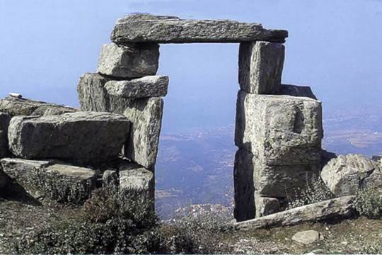
The fortified perimeter (310m) encloses an area of ca 0.35ha. An impressive gate, made of cipollino marble (or Karystos marble) blocks, is preserved to a height of 3.5m. The masonry is irregular trapezoidal with use of triangular chinking stones.
Two trenches perpendicular to the S wall revealed that the natural rock was carved and flattened to support the foundations.
At the eastern side there is the church of Panagitsa built in the 12th century and renovated much later. Near the top of the mountain there is the small chapel of Agios Nikolaos and the ruins of another chapel, Agios Ioannis.
| First entry in Kastrologos: | October 2013 |
Sources
- Swiss School of Archaeology in Greece - 2005 Archaeological report
|
|
| Access |
|---|
| Approach to the monument: |
| There is a mountain path leading to the castle from the base of the hill. |
| Entrance: |
| Free access |
| Other castles around |
|---|
| Castle of Aktaion |
| Tower of Dystos Acropolis |
| Fylagra Castle |
| Bourtzi of Karystos |
| Fortress of Karystos |
| Kastri of Tsakeoi |
| Chartzani |
| Ellinopyrgos of Zarka |


