

Kato Chorio, Ierapetra, Rhithymna,Crete
Koules of Episkopi


| Location: |
| North of Kato Chorio of Lasithi region in Crete |
| Region > Prefecture: |  |
| Crete Rhithymna | |
| Municipality > Town: | |
| City of Ierapetra • Kato Chorio | |
| Altitude: | |
|
Elevation ≈ 165 m (Relative Height≈110 m) |
| Time of Construction | Origin | |
| 1868 | OTTOMAN |
|
| Castle Type | Condition | |
| Small Fort |
Rather Poor
|
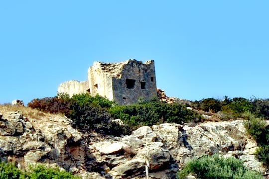
One of the many small forts -the so called “koules”- built by the Turks after 1886 following the outbreak of the Cretan revolution that year.
History
The “Isthmus of Ierapetra” is the narrowest part of Crete located in Lasithi with a lenght of 12km connecting the north coast to the south coast of the island.
The Ottomans built four koules in this strategic piece of land: in Pachia Ammos, in Vasiliki, in Episkopi and in Kentri.
The Koules of Episkopi was a central fort, larger that the other nearby koules and it was used for the station of a larger military unit. The Turkish name of these central forts was “kislas”.
Its shape was rectangular with towers-bastions at each corner. Its dimensions are 15x40m. It was built in 1868 by Avni pasha.
It could communicate with the fort of Vasiliki to the north and the fort of Kentri to the south. The Koules of Kentri was the intermediate military station between Episkopi and the fortress of Ierapetra and today does not exist, as a school has been built in its place.
| First entry in Kastrologos: | October 2015 |
Sources
- Giannis Christakis, "Historical Fortification Monuments of Crete (330BC-1898)", Publication "Ktitika Grammata", 2004
|
|
| Access |
|---|
| Entrance: |
| Free access |


