

Kippoula, Anatoliki Mani, Laconia,Peloponnese
Castle of Ano Poula
or Castle of Makryna or Ano Kipoula
1
2 / 11

3 / 11

4 / 11

5 / 11

6 / 11

7 / 11

Eleftherotra chapel-Triantafyllos Adamakopoulos/topoguide.gr
8 / 11

Triantafyllos Adamakopoulos/topoguide.gr
9 / 11

Triantafyllos Adamakopoulos/topoguide.gr
10 / 11

Triantafyllos Adamakopoulos/topoguide.gr
11 / 11

Triantafyllos Adamakopoulos/topoguide.gr

THE END
| Location: |
| In SW Mani, north from Cape Cavo Grosso, on a ridge above the village Kipoula, south Peloponnese |
| Region > Prefecture: |  |
| Peloponnese Laconia | |
| Municipality > Town: | |
| City of Anatoliki Mani • Kippoula | |
| Altitude: | |
| Elevation ≈ 270 m |
| Time of Construction | Origin | |
| Middle-Byzantine | BYZANTINE |
|
| Castle Type | Condition | |
| Medieval Settlement |
Rather Poor
|
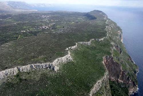
In the arid landscape of SW Mani there are several ridges. One of them is the Makryna ridge, along the west coast north from Cape Cavo Grooso. The ridge extends for about 4km from the Cape Droso until Cavo Grosso, 200-300m above the sea level and 300-600m wide.
In the middle of this plateau, above and to the west of the village Kippoula, there is a complex of small ruined settlements protected by a thick stone wall on the eastern side. This is the “castle of Ano Poula”.
History
We do not know when the fortification was built.
We know that the location was inhabited since antiquity until the mid 17th century.
It is almost certain that the ancient city Ippola was there. We do not know what happened later, in the Middle Ages, but most probably the castle continued to be useful in the 5th-6th centuries when barbaric raids were ravaging the rest of Greece and especially after the beginning of the era of piracy in the 8th century and of the threat by the Saracens.
There are several churches in Ano Poula dated back to 10th, 11th century, some of them preserving their byzantine frescoes. Apparently, those days the place was inhabited.
It is not known whether Ano Poula was ever taken by the Franks. In any case, they did not attempt to make any modifications in the fortification, as there are no signs of their presence there, nor of their construction methods either.
Later, the Ottomans could not penetrate so deep south in the Mani territory, so there is no question about an Ottoman influenc.
According to a 1618 census, 30 families were living in Ano Poula. A little later however, the population moved lower to less hostile ground and Ano Poula was abandoned.
All these do not reveal any info about the time of construction of the walls. Its big-stone and rather primitive technique could be from any age: ancient, mid-Byzantine or even meta-Byzantine.
We can assume (without proof) that the wall was built in the 8th century, the latest, in a period when the pirate threat could not be taken lightly and when the Byzantine central power was very weak to support the building of a more proper castle.
Structure, Fortification & Buildings
The wall covers only the east side of the plateau. The western side is a cliff high above the sea and there was no need to defend it it. The length is around 400m and its height max. 3m (it was not much higher in the good days).
In the plateau, there are 6 clusters of buildings, one of which is lower on the slope and two from the others are outside the walls. In total, in Ano Poula, we can spot the ruins of around 70 houses and 10 (?) churches.
| First entry in Kastrologos: | October 2012 | Last update of info and text: | April 2020 | Last addition of photo/video: | April 2020 |
Sources
- Panayiotis S. Katsafados, The castles of Mani, Athens 1992 (Greek book)
- Website MANH-MANI -Some observations regarding the population of the castle of Ano Poula in the 13th century
- John Chapman, website Mani: A guide and history - grand magne
- Website exploring-greece - Ανω Κηπούλα
- Video by the user ΜΑΡΙΑ ΤΣΙΡΟΒΑΣΙΛΗ ΑΝΩ ΠΟΥΛΑ ΜΑΝΗΣ
- Photos 7-11 Triantafyllos Adamakopoulos - topoGuide.gr
|
|
| Access |
|---|
| Approach to the monument: |
| There are some difficults mountain paths from Kippoula and from Lagoudies which lead after a difficult hike to the plateau. |
| Entrance: |
| Free but difficult access |


