

Chora, Samothraki, Evros,East Macedonia & Thrace
Castle of Samothraki
or Chora Castle
1
2 / 13

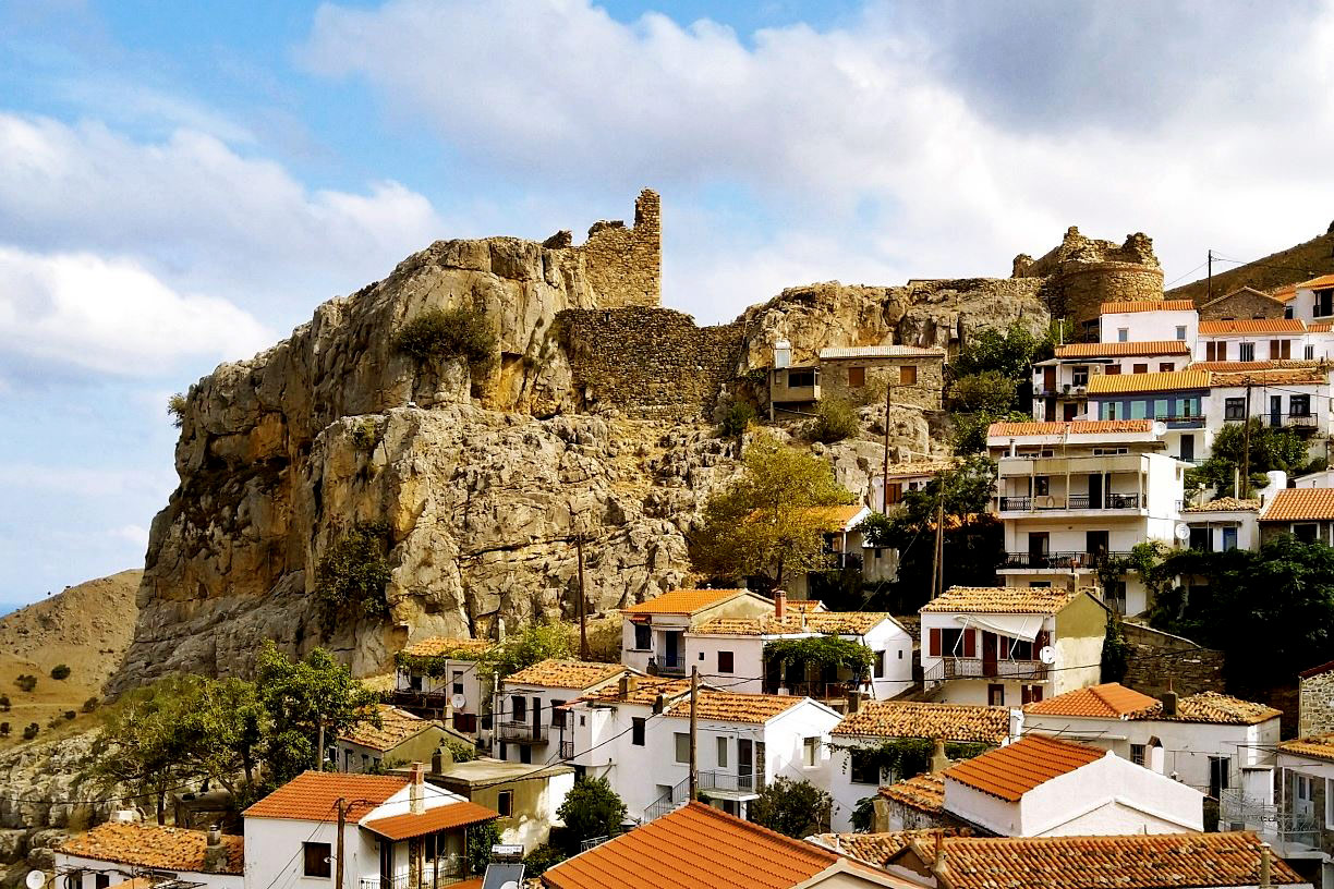
view from the east
3 / 13

old view from SE (with the police station still on top)
4 / 13

old view from SE (with the police station still on top)
5 / 13

old view from SE (with the police station still on top)
6 / 13

the tower of Gattilusi in the upper castle
7 / 13

view of the lower castle and the main gate from the inside
8 / 13

the east side of the lower castle with the gate and the two towers
9 / 13

the east side of the lower castle with the gate and the two towers
10 / 13

the tower and the gate of the upper castle
11 / 13

the sign embedded in the wall of the Gattilusi tower of the lower castle
12 / 13

the sign embedded in the wall of the Gattilusi tower of the upper castle
13 / 13


THE END
| Location: |
| Chora, Samothraki island in North Aegean |
| Region > Prefecture: |  |
| East Macedonia & Thrace Evros | |
| Municipality > Town: | |
| City of Samothraki • Chora | |
| Altitude: | |
| Elevation ≈ 240 m |
| Time of Construction | Origin | |
| 1431-1433 | GENOAN |
|
| Castle Type | Condition | |
| Castle |
Not Good
|
History
In a nutshell, the castle of Chora of Samothrace was built by the Genoese ruler of Ainos Palamede Gattilusio around 1431-1433, on top of a Byzantine castle that had existed there since the 10th century, at least. The castle remained in the hands of the Genoese for a very short time, as it was captured in 1456 by the Turks.
In more detail:
The hill of the castle has been inhabited since the Neolithic era as evidenced by megalithic findings, and has never ceased to be inhabited since then.
The medieval history of Samothrace is largely unknown. During the Middle Ages, the island is barely mentioned in the sources, in contrast to Antiquity –until the Late Roman period– when the reputation of the island reached beyond the Greek lands, and Samothrace had grown into an international religious center due to the Kaverian Mysteries and the apocryphal rituals in the Sanctuary of the Great Gods (in Paleopolis).
After the 4th century, when the Mysteries were abolished, Samothrace began to decline and became a place of exile for the Byzantines. During the 8th and 9th centuries it suffered from raids of Slavs and Saracens.
There are indications that during the Middle Byzantine Period, the island had been transformed into a monastic center consisting of metochia (dependencies) that belonged directly to the monasteries of Constantinople and not to mount Athos as was the case with the other islands of the North Aegean.
The Ottoman admiral and cartographer Piri Reis in his work “Book of Navigation” (Kitap Bahriye, 1521) speaks of Samothrace as follows:
This island is called Semandirek in Turkish. The unbelievers, however, call it Santa Medirake. The island is a spherical mountain, so high that it never lacks snow. Its lowlands are full of pine trees. It is thirty-five miles in circumference. In the old days it was a center of monasteries, while today the monasteries where the monks lived are in ruins. One of these monasteries is called Paliambolou [Palaiopolis]. It is a ruin by the sea.
The first medieval fortification in Chora probably dates back to the end of the 10th century. Remains of this mid-Byzantine fortification is a strong circular tower in the SE corner of the enclosure (point 1 on the plan), which is built with semi-processed stones and brick zones. Also, in the west part of the citadel, a rectangular oblong tower (point 6), with a vaulted roof on the first floor, is also Byzantine. It probably served as a cistern.
This fortification was strengthened and rebuilt in the 15th century by the Genoese rulers Gattilusi.
This is the story of how the Gattilusi ended up in Samothrace:
In 1376 the Byzantine emperor Andronikos IV Palaiologos, who had the support of the Genoese of the parish of Galata in the dispute with his father John V (whom he had briefly dethroned) granted the city of Ainos (today’s Enez in Eastern Thrace, in the Delta of the Evros) to the Genoese Niccolò Gattilusio, brother of the ruler of Lesbos Francesco I Gattilusio. Niccolò died in 1409 and was succeeded by his nephew Palamede Gattilusio, brother of Francesco II of Lesbos. (It should be noted that the Gattilusi of Lesbos and the Gattilusi of Samothrace were close relatives, but neither of them was subordinate to the other. Also, both had always excellent relations with the imperial dynasty of the Palaiologoi).
In 1433 the traveler Bertrandon de la Broquiere mentioned that Samothrace, in recent years, is the property of Palamede Gattilusio, the Genoese ruler of Ainos. The arrival of the Gattilusi in Samothrace must have taken place in 1430 under unspecified circumstances. Either the island was given to Palamede by the Byzantine emperor or, more likely, Palamede encroached on it (we know that the same thing happened with Thassos, which was arbitrarily occupied by the Gattilusi of Lesbos in 1434).
At that time Samothrace must have been almost deserted being easy prey to the constant raids of the Turkish pirates of Asia Minor, and probably no one was bothered that Palamede added it to his fiefs.
Here we should point out that it is very likely that the Turkish Sultan gave his approval for this annexation, as, at that time, all the local rulers of the Balkans had already declared themselves vassals of the Ottomans (along with the Byzantine emperor).
Almost immediately upon his arrival in Samothrace, Palamede Gattilusio began the reconstruction of the castle of Chora and the ancient fortification in Paleopolis. We know this from the embedded signs on the walls of the two towers which include the dates 1431 (the upper tower) and 1433 (the lower tower).
Palamede Gattilusio managed to have good relations with the Ottomans and did not lose the territories of his hegemony in the stormy period shortly before and shortly after the Fall of Constantinople (1453). In fact, in 1455, Mohammed the Conqueror also granted him Imbros. In the same year, Palamede died.
Palamede was succeeded by his second son Dorino II. The widow of his first-born son Giorgio (who was the daughter of Lucas Notaras) felt wronged by this development and sought the help of the sultan. Muhammad II, annoyed that he was not asked about the succession process, intervened immediately: He captured Aino in 1456 and shortly after sent a fleet of 10 ships that captured Samothrace. Dorino II hastened to Adrianople to try to convince the sultan and keep his territories. Mohammed II did not change his mind and instead proposed to Dorino to become governor in Zichna. Dorino could not refuse, but on his way to Zichna he killed the Turks who accompanied him and took refuge with his wife’s uncle Guliemo Crispo, Duke of the Archipelago, in Naxos.
In 1460, Mohammed II, wanting to reward the former Despot of Moreas Dimitrios Palaiologos who had surrendered Mystras to him without a fight, granted him the old possessions of the Gattilusi in the Northern Aegean: Ainos, Limnos, Imbros, Thassos, Samothrace. In a few years, however, Dimitrios fell out of favor and was kicked out.
Later, in April 1466, in one of the military operations of the First Venetian-Turkish War (1463-1479), the Venetian fleet under the leadership of the admiral (Capitano generale da mar) Vettore Cappello occupied the northern Aegean islands of Lemnos, Thassos, Samothraki and Imbros.
The islands remained under Venetian control until the end of the war and returned to the Ottomans with the peace treaty of Constantinople in 1479.
Structure, Fortification & Buildings
The castle of Chora of Samothrace rises on the northeastern edge of the town,
on a steep rock.
It is a relatively small castle. It occupies an area of 1880 sq.m.
It consists of two fortified enclosures. The upper castle (the “citadel”) occupies the ellipsoidal plane of the top of the rock on the western side, while the lower castle is located a little lower, on the eastern side of the rock, a few steps from the last houses of Chora.
The lower castle is protected by a wall on its north and south sides. On its west side is the upper castle, while the wall on the east side had been demolished, though has recently been partially restored. The wall is not continuous, as it is interrupted by sections of rock that provided adequate defensive protection. The lower castle includes a multi-storied rectangular tower near the north-east corner and the cylindrical Byzantine tower in the south-east corner, at the junction of the east and south sides. In the space between the cylindrical and the rectangular tower, a gendarmerie station was built in recent years by demolishing the eastern wall.
That said, recent photos (photos 1,2,7,3) show that the police station has been demolished and the eastern wall (which was a wall of the gendarmerie building) has been restored. This must have been done after 2010.
The cylindrical tower (point 1 of the layout, photo 8, 9 – left) has a diameter of 7m and is preserved at a height of 12m. It has been built with large stones and lime mortar containing broken tiles. Its masonry is reinforced in height with six horizontal zones, each with three rows of bricks. In its current state of preservation, it has no openings and does not maintain its superstructure. Most probably, this particular tower is a remnant of the Middle Byzantine fortification (late 10th century).
The rectangular northeast tower of the lower castle (point 2, photo 8 – right) is preserved at a height of approximately 11.30m and has dimensions of 10.32✖7.55 m. Only two floors of the tower are preserved today and the underground vaulted cistern. On the its walls, arrow-loops are opened for defense, of which 5 survive today. On the south side of this tower, above a structure with a pointed end, there is an embedded marble plaque with the coats of arms of the Gattilusi and of Palaiologoi (photo 11). According to the inscription, the tower was erected in 1433 by order of the lord Palamede Gattilusi, by the “maister” Konstantinos.
The upper castle (the citadel) has an area of 930sq.m. It has no fortification on the outside as it is protected by the steep rocks. Its eastern side (bordering the lower castle) is reinforced with a rectangular tower (point 3, photo 10 – left and photo 6) measuring 5.60✖7.25m. and is maintained at a height of 12m. about. It is the most visible point of the castle.
On its eastern facade there is another built-in marble slab with the coats of arms of Palaiologoi and Gattilusi and an inscription (photo 12) referring to the construction of the tower by Palamede and maister Konstantinos in 1431.
On the inner wall that separates the upper from the lower castle, to the north of the second Genoan tower, there is a gate (point 5, photo 10 – right). The entrance was formerly protected by a machicolation supported by two cantilevers (only the bases of the cantilevers remain).
Within the citadel are also preserved, at a low height, the remains of two small rectangular stone-built cisterns (=water tanks, points 6 and 7), one of which is Byzantine, as well as the ruins of various buildings with undetermined use and dating.
| First entry in Kastrologos: | March 2012 | Last update of info and text: | June 2023 | Last addition of photo/video: | June 2023 |
Sources
- Αθηνά-Χριστίνα Λούπου ΑΡΧΑΙΟΛΟΓΙΚΟΝ ΔΕΛΤΙΟΝ 56-59, issue Β3β, page. 827
- Ευάγγελος Παπαθανασίου, Σαμοθράκη: Πρώτες υποθέσεις και συμπεράσματα μιας επιφανειακής έρευνας, Το Αρχαιολογικό Έργο στη Μακεδονία και στη Θράκη (ΑΕΜΘ τεύχος 17, 2003), Θεσσαλονίκη 2005, σελ.29-49
- Βυζαντινόν Χρονολόγιον
|
|
| Access |
|---|
| Approach to the monument: |
| Easy acces from Chora via a paved path that has been constructed recently. |
| Entrance: |
| Ticket entrance. Limited hours. |
| Other castles around |
|---|
| Fonias Tower |
| Towers of Paleopolis |


