

Agios Ioannis, North Kynouria, Arcadia,Peloponnese
Estella Castle
or Castle of Oria or of Agios Ioannis Malevos or Xirokampi castle
1
2 / 16

the keep of the castle
3 / 16

the keep of the castle
4 / 16

5 / 16

photo by Kostas Tragakis
6 / 16

photo by Kostas Tragakis
7 / 16

photo by Kostas Tragakis
8 / 16

9 / 16

notice the walls at the slopes of the hill
10 / 16

notice the walls at the slopes of the hill
11 / 16

The inner yard seen from the keep
12 / 16

13 / 16

view from west; the castle in Paralio Astros is visible
14 / 16

15 / 16

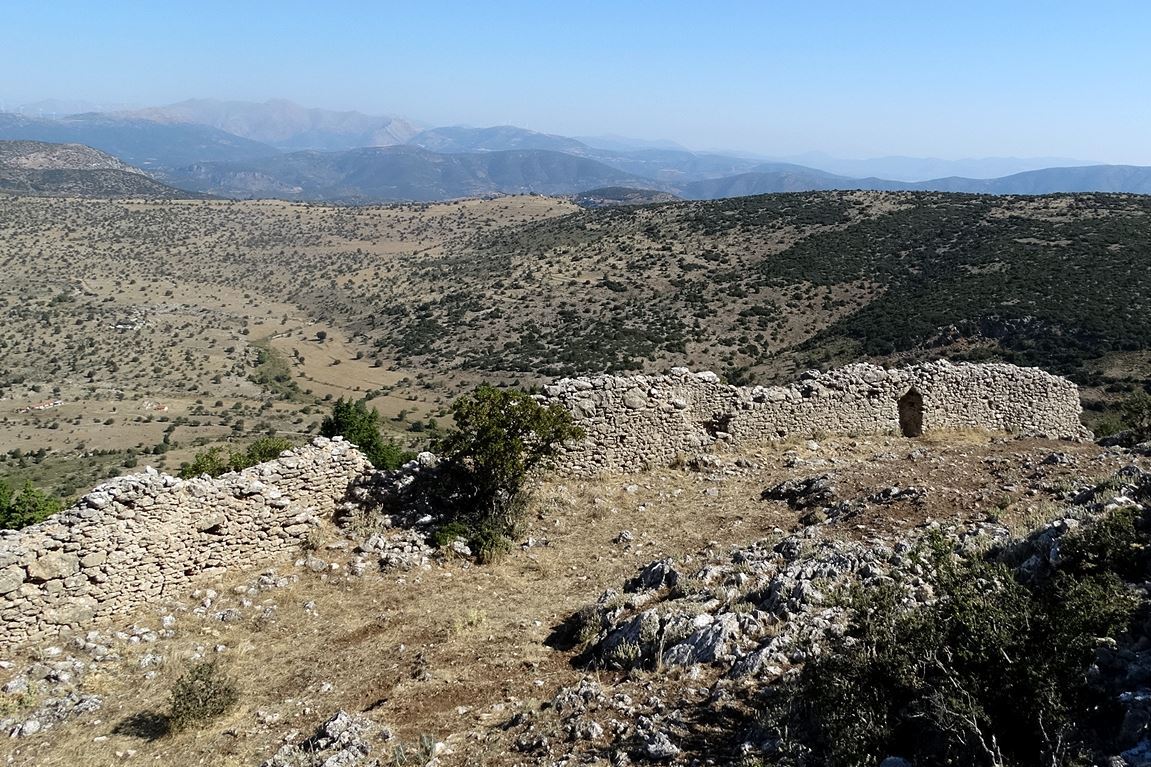
part of the external southern wall
16 / 16

part of the wall of the upper part of the fortification

THE END
| Location: |
| At the location Xirocampi, near Agios Ioannis, Kynouria area, Peloponnese |
| Region > Prefecture: |  |
| Peloponnese Arcadia | |
| Municipality > Town: | |
| City of North Kynouria • Agios Ioannis | |
| Altitude: | |
|
Elevation ≈ 970 m (Relative Height≈350 m) |
| Time of Construction | Origin | |
| 1256 | FRANKISH |
|
| Castle Type | Condition | |
| Castle |
Rather Poor
|
A Franksih castle on a characteristic conical hill, on a bare plateau called “Xerokambi”, between the villages of Agios Ioannis (Agiannis) and Agios Petros of North Kynouria.
The position allows visibility to a large area. It surveys the passage which starts from Astros and the ancient Thyrea and passes under Mount Zygos (part of Parnon range) to reach Lacedaemon.
History
The identification of the castle has puzzled researchers. It was not easy to find the location of “Astros” because of the existence of similar names in several places on the coast and inland of northeastern Kynouria. As a result, the terms Astros, Astritsi and Estella are confused in geographical catalogs, old maps and historical maps.
Estella castle is mentioned in the Aragonese version of the Chronicle of Morea. According to the Chronicle, the prince of Achaia, William Villehardouin, built in 1256, shortly after the conquest of Monemvasia (in 1248), the Castello della Estella to control the disobedient Tsakonians who lived “suso en las montanyas”, ie in the mountains.
Τoday, there is no doubt that the castle at Xerokambi is the Frankish fortress mentioned in the Aragonese Chronicle of Morea as “Estella” (translation of the Greek word Astros). This castle has become also known by the popular name “Castle of Oria”, which is found in other parts of Greece, associated with legends around its conquest by the enemy.
There is not much information about the history of the castle. It is alleged that shortly after its founding it passed into the hands of the Greeks. This must have happened after 1262 when war began between the Byzantines of Mystras and the Franks. It is possible that the possession of the castle changed frequently at that time, as the area was on the frontier.
During the first decades of the 14th century, when Andronikos Palaiologos Asanis, as commissioner of Morea, extended the rule of Mystras and took many Frankish castles in the Peloponnese, it is certain that the castle of Estella became Byzantine and remained Byzantine for at least a century.
According to Hopf, in 1423 the castle is still in the hands of the Greeks. At this time it belongs to the lord of Tsakonia Leontas Melissinos.
Hopf's geographical tables show that it belonged to the Venetians in 1463, while in 1467 it belonged to the Turks.
From that time Estella castle seems to have been abandoned, as it ceased to have military value to the Ottomans.
Structure, Fortification & Buildings
The shape of the castle follows the terrain, the western side of which is smooth and the eastern more steep, with natural defensive protection. It consists of two fortifications that protect the western most vulnerable side. An outer wall surrounds a settlement and an inner wall, at the top of the hill, protects the citadel. The total area of the castle is about 22,000 sq.m.
No entrance has been found in the outer wall. In the inner courtyard there is a small gate (see photos 2,4,7) which was the main entrance of the citadel, while near the northern end of the wall there is a second opening. There are indications for a third entrance in the southeastern part of the wall.
The outer wall is made of dry stone.The fortification of the citadel consists of stonework with plaster.
At the highest point there is a surveillance tower (or perhaps a keep – donjon) with a square layout that is maintained at a height of 3 meters (photo 1,6,8). Its construction is stonework with plaster, while on the west side of the tower the presence of bricks is noted.
Inside the outer fortification wall, traces of a settlement are found that consist of several single-aisled rectangular structures made of dry stone. A two-storey building only stands out because of a vestibule and the two spaces it has.
| First entry in Kastrologos: | October 2012 |
Sources
- Καρποδίνη Ε., Κάστρα της Πελοποννήσου, Αθήνα 1993, 242-243
- Μπάλλας Α., «Κάστρα της Κυνουρίας. Επισκόπηση των μεσαιωνικών κάστρων της Τσακωνιάς», Πελοποννησιακά ΚΣΤ΄ (2001-2002), 208-210
- Πέππας Ι., Μεσαιωνικές σελίδες της Αργολίδας, Αρκαδίας, Κορινθίας, Αττικής, Αθήνα 1990, 178, 182-185
- Ρωμαίος Α., Τοπογραφικά της Φραγκοκρατίας, Πελοποννησιακά Β΄(1957), 23-24
- Σαραντάκης Π., Αρκαδία: Οι Ακροπόλεις – Τα Κάστρα & Οι πύργοι της σιωπηλά ερείπια μιας δοξασμένης γης, Αθήνα 2006, 152, 155-158
- Ιωάννης Θ. Σφηκόπουλος, «Τα Μεσαιωνικά κάστρα του Μορηά», Αθήνα,1968, σ.σ. 199-201
- Website ecastles - Εστέλλα, κάστρο
- Information by Mr. John Kourogiorgas
- Website astrosgr.com - Τα κάστρα μας : Κάστρο Εστέλλα ( στον Αγιάννη ) και Κάστρο Παραλίου Άστρους
- Φωτογραφίες 5,6,7 Κώστας Τραγάκης
- Δημήτριος Περσέας Λουκίσσας φωτογραφίες 1, 2, 3, 15, 16, (Αύγουστος 2017) και πληροφορίες από το βιβλίο του «ΑΡΓΟΛΙΔΑΣ-ΚΟΡΙΝΘΙΑΣ ΠΕΡΙΗΓΗΣΙΣ - Ένα σύγχρονο οδοιπορικό στη γη των Μύθων και της Ιστορίας», Τόμος Β’, Ανοιχτή Πόλη, Αθήνα 2022, σ. 226-232
|
|
| Access |
|---|
| Approach to the monument: |
| - |
| Entrance: |
| Free but difficult access |


