

Avantas, Alexandroupolis, Evros,East Macedonia & Thrace
Avantas Castle
or Kereopyrgos
1
2 / 16

August 2022
3 / 16

August 2022
4 / 16

The first gate, right, and the second gate at the left (Aug 2022)
5 / 16

The second gate, between two towers - August 2022
6 / 16

tower 1 from SE of Avas castle
7 / 16

the wall above tower 3
8 / 16

towers 2 and 3 with the second gate, inside
9 / 16

the arch of the first gate
10 / 16

tower 1 and the first gate
11 / 16

walls of Avas castle from above
12 / 16

13 / 16

May 2018
14 / 16

May 2018
15 / 16

August 2022
16 / 16

August 2022

THE END
| Location: |
| On a hill above the village Avantas in Alexandroupoli, NE Greece |
| Region > Prefecture: |  |
| East Macedonia & Thrace Evros | |
| Municipality > Town: | |
| City of Alexandroupolis • Avantas | |
| Altitude: | |
|
Elevation ≈ 180 m (Relative Height≈100 m) |
| Time of Construction | Origin | |
| 6th cent. | BYZANTINE |
|
| Castle Type | Condition | |
| Byzantine City |
Rather Poor
|
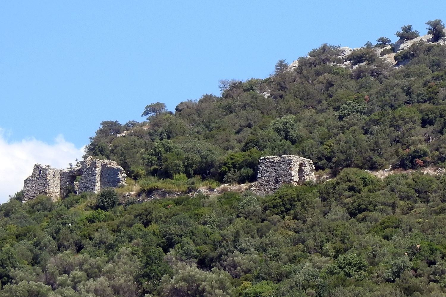
A castle on a rocky hill, 100 m from the village Avantas and around 10km north of Alexandroupolis.
Until 2019m the castle was difficulta to spot due to the thick vegetion.
The shape of the rock from a certain angle resembles a horn fueling the hypothesis that this might have been the unidentified byzantine city of Kereopyrgos or Cereopyrgos (more below).
History
The castle has not been systematically researched. The construction has no chronological phases. The masonry does not help in dating. Various surface finds, however (shells) come all from the 14th century.
It is very close to the other castle of Avas, castle Potamou but it does not belong to the same period. In fact, it must have been considerably older.
The two fortresses controlled the passage to the interior of Thrace and the Rhodope mountain. The location is also on a passage to Constantinople, alternative to Egnatia Road, which is south, closer to the sea.
Having two strong castles in such close proximity is a bit unusual. Perhaps the passageway was a very important in a period and one castle was considered not enough. Another (arbitrary) explanation is that perhaps the castles have been competitive and belonged to different local rulers.
Interestingly, while foreign and Turkish travelers mentioned the castle of Potamou, they make no mention of the castle of Avas (to our knowledge) although the fortification is by no means negligible. Perhaps, even in the past, it was well concealed by the dense vegetation. But most probably this happened because the castle was abandoned early, even before the start of the Turkish occupation.
Our theory is that this castle must have been the so far identified city of Kereopyrgos, which is mentioned in the Synekdemos of Hieokles, a 6th century list of divisions and cities in the Byzantine empire. The book records 7 cities in Rhodope, one of which is Kereopyrgos (the other 6 being already identified).
The main reason we propose the identification of the castle of Avas with Kereopyrgos is the etymology of the name in combination with the shape of the hill of the castle: Kereopyrgos is composed of two words, Keras[horn]+pyrgos[tower]. So the name means horn-tower. On the other hand, the shape of the rock from the southeast clearly resembles a horn.
If this theory is true, then the castle was one of those built during the reign of Emperor Justinian. However Kereopyrgos is not mentioned in Procopius’ De aedificiis, a list of all places fortified by Justinian. Kereopyrgos, as a city, could not have been left out from that huge fortification project, so it must be included in Procopius with a modified name. It has been proposed that Kereopyrgos is the new castle Kiriparon mentioned by Procopius. We can’t be sure.
Structure, Fortification & Buildings
The fort consists of a wall of approximately 140 meters, parallel to the contours and a second, about 40 meters, almost perpendicular to it. The fortified area is of a generally oblique rectangular shape and is slightly less than 1 hectare. The fortification is developed on the slope from which it is possible to rise on the hill, while the rest is not protected by walls because the rough terrain is enough.
The fortification was reinforced by four rectangular towers. There were two gates: one at the end of the wall protected by a tower and one in the middle of the wall, between two towers.
There are no architectural remains, which might testify residential occupation. The oldest construction elements are some massive domes that have been used in various parts of the fortification which might indicate an older fortification.
| First entry in Kastrologos: | May 2012 | Last update of info and text: | June 2018 | Last addition of photo/video: | August 2022 |
Sources
- Website Summer Hotels> Αλεξανδρούπολη
- Konstantinos Tsouris-Athnasios Brikas,BYZANTINE FORTIFICATIONS IN EVROS (in Greek), Thessaloniki 2006 (source was given by the archaeologist Mr. Kostas Ketanis)
- Κωνσταντίνος Τσουρής , ΑΡΧΑΙΟΛΟΓΙΚΟΝ ΔΕΛΤΙΟΝ τεύχος 53/Α-Μελέτες (1998), σελ. 441
|
|
| Access |
|---|
| Approach to the monument: |
| The castle is on a rocky cliff 200m north of the village Avantas. The access to the castle from the bottom of the rock is difficult. |
| Entrance: |
| 20 min uphill walking is needed from the foot of the cliff until the gate of the castle through a difficult path. |
| Other castles around |
|---|
| Tower of Asproula |
| Castle of Makri |
| Castle of Nea Santa in Rhodope |
| Castle of Potamos |


