

Kalidona, Zacharo, Elis,West Greece
Castle of Kalidona
or Glatsa castle or Gyftokastro


| Location: |
| On a conical hill 500m south of Kalidona and 1800m NE of Anilio (Glatsa) near Zacharo, Elis |
| Region > Prefecture: |  |
| West Greece Elis | |
| Municipality > Town: | |
| City of Zacharo • Kalidona | |
| Altitude: | |
|
Elevation ≈ 410 m (Relative Height≈250 m) |
| Time of Construction | Origin | |
| Various periods | ANCIENT |
|
| Castle Type | Condition | |
| Dry-Stone Fortification |
In Ruins
|
A settlement that was inhabited from the ancient times, perhaps the archaic period, until the Middle Ages. The fortification is mostly ancient, while the houses inside are medieval.
The Name of the Castle
The castle is also called “castle of Glatsa” or “castle of Anilion”.
Anilion is another village nearby, the name of which was Glatsa until 1927.
The castle is called by the locals Paliokastro (=old castle) or Gyftokastro (=castle of the gypsies). The latter probably implies that the place was inhabited by Roma which explains why there are many traces of metal workshops in the settlement. (In the late-Byzantine period and later, metallurgy was a vocational filed almost exclusively for the Romani people.)
History
The settlement was first reported in 1819 by Edward Dodwell who did not himself visit the site. Travelers and scholars noted the site in the early 1860s as “Paleokastro of Sartena” -the Ottoman name of village Kalidona.
In 1908, the castle was researched by Wilhelm Dörpfeld founder of the German Archaeological Institute in Athens, who thought that it belonged to the Mycenaean or Classical era. As a result, the Greek government christened nearby village Sartena with the name Kalidona based loosely on Strabo's mention of a town Celadon.
The site was revisisted in 2006-2010, by the German Archaeological Institute, again. This time it was concluded that the site was first inhabited and fortified around the end of Proto-Helladic period, i.e. around 2200 BC.
The castle was used also in the Byzantine years, as there are walls and tower built in that period with materials from the ancient acropolis. There are also other findings (coins, pottery) from that period.
Inside the walls there are ruins of more than 50 houses which are all medieval constructions. The absence of mortar and the absence of a church misled earlier researchers to assume that this was an ancient site.
Structure, Fortification & Buildings
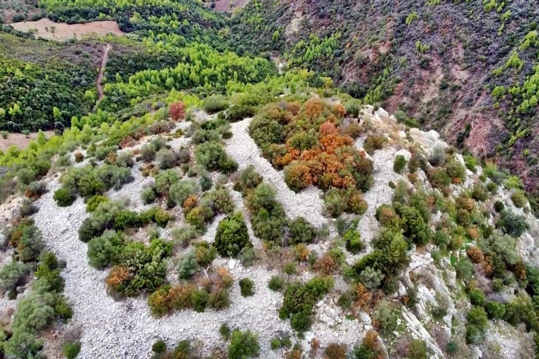
The castle of Kalidona is unique in its compact organization and arrangement along two rectilinear sets of walls.
The site consists of an area enclosed by two lines of fortification. The shape of the site is irregular covering an area of ca. 70✖70m along a northwest-southeast axis. Unlike other settlements, there is no evidence of cistems or other water provisions within
the site.
The castle is built directly above the Bikrouva stream. Two springs located about 750 m east of the castle would have provided the site with ample water.
The settlement is organized around two contiguous areas separated by two
circuit walls. The walls are ca. 1m wide and follow an orthogonal orientation. The outer circuit contains six tower protrusions. The inner circuit measures about 30 30m and contains remains of four to six structures. Eleven additional buildings were recorded within the area of the outer wall, five of which bond with the fortification circuit. Another thirteen houses were found outside the walls on the lower slopes.
The buildings are
houses conforming to square (5✖5m) and rectangular (5
10m) plans. All buildings are constructed of dry masonry; no mortar was found. They survive in rubble piles with a maximum preserved height of ca.
1 m. The circuit walls survive in better condition due to their greater wall thickness.
Νο evidence of roads or paths was found in the site. Most of the ascent extends
over limestone outcroppings. Α gate at the southwest wall of the outer circuit indicates
the main access into the site was here. An opening at the southwest comer of the inner
circuit could be interpreted as the point of entry into the inner town. The large open space between the two gates would have served as a thoroughfare.
Medieval roof tiles covered much of the rubble destruction. In addition to ceramics, a piece of iron slag was found inside the westernmost house. This may be associated to smelting activity, taking place within the medieval settlement.
| First entry in Kastrologos: | November 2016 | Last addition of photo/video: | November 2024 |
Sources
- Konstantinos Kourelis, “MONUMENTS OF RURAL ARCHAEOLOGY MEDIEVAL SETTLEMENTS ΙΝ ΤΗΕ NORTHWESTERN PELOPONNESE”, Presented to the Faculties of the University of Pennsylvania in Partial Fulfillment of the Requirements for the Degree of Doctor of Philosophy, 2003
- Website Αριστομένης ο Μεσσήνιος - Κάστρο Καλίδονας, Τριφυλία
- ΑΡΧΑΙΟΛΟΓΙΚΟΝ ΔΕΛΤΙΟΝ, τόμος 53 (1998), τεύχος Β1, σελ.317
- Video by the user stathako.k Κάστρο Καλίδονας - Νομός Ηλείας
|
|
| Access |
|---|
| Entrance: |
| Free access |


