

Skepasto, Volvi, Thessaloniki,Central Macedonia
Tower of Skepasto


| Location: |
| On the edge of a rocky outcrop, one kilometer NE from the village of Skepasto in the prefecture of Thessaloniki. |
| Region > Prefecture: |  |
| Central Macedonia Thessaloniki | |
| Municipality > Town: | |
| City of Volvi • Skepasto | |
| Altitude: | |
|
Elevation ≈ 540 m (Relative Height≈40 m) |
| Time of Construction | Origin | |
| Unknown | BYZANTINE |
|
| Castle Type | Condition | |
| Ruined Tower |
In Ruins
|
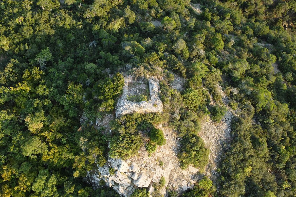
Ruins of a square tower on a rocky ledge on the slope of Mount Kerdylli, northeast of the village of Skepasto.
Location & Strategic Scope
The position of the tower oversaw the northern entrance to the “Vromolimnes” (=dirty lakes,from two shallow lakes dried up in 1958) plateau through the strait of Skepastos. The Skepastos strait was a narrow passage in the neck that forms between the Kerdyllios mountain and the Vertikos mountain and was part of a road that started from the plain of Serres and ended at the plateau of Vromolimnes.
History
Nothing is known about this tower from historical sources.
Territorially, the area seems to have belonged to the Archonteia (=barony) of Stefaniana during the Middle Byzantine Period, which evolved into the Katepanikion of Stefaniana in the late Byzantine years, with the neighboring Stefaniana (Stephanina) and their castle as the center of the area.
The tower was probably built at more or less the same time as the neighboring Castle of Mavrouda which dates – with some reservations – to the Middle Byzantine Period.
Structure, Fortification & Buildings
The tower is almost rectangular with dimensions of 6.0✖6.5 meters and a maximum surviving height of 2 meters.
The thickness of the wall varies between 1.5 and 1.8 meters.
Its construction consists of stones of different sizes with connecting mortar between them. Most of the tower has collapsed and is covered by dense vegetation. What is preserved is a part of the closed ground floor that was a cistern. We know this from the remains of mortar on the inner walls.
Around the tower, in a radius of 10 meters, there are scattered building remains. They appear to be ruins of additional fortifications around the tower.
| First entry in Kastrologos: | November 2022 |
Sources
- Research, text and photos by Sakis Amfitreidis and his blog ΑΜΦΙΤΡΕΙΔΗΣ (Oct 2022)
- Ευάγγελος Παπαθανασίου- Μαρίζα Τσιάπαλη, ΑΠΟ ΤΑ ΜΑΚΕΔΟΝΙΚΑ ΣΤΑ ΘΕΣΣΑΛΙΚΑ ΤΕΜΠΗ - 2019, κεφάλαιο: Η Κλεισώρεια Ρεντίνης-Στεφανηνών: Ορισμός-Χαρακτηριστικά- Αμυντική οργάνωση μέσα στο χρόνο σελ. 36-37
- Αθηνά Τοκμακίδου-Περικλής Φωτιάδης, Τεκμήρια Ιστορίας στον Δήμο Βόλβης-2019 (Αφιέρωμα στα 40 χρόνια προσφοράς του Νικόλαου Μουτσόπουλου στην γη της Μυγδονίας), κεφάλαιο: Μικρή Συμβολή στην ιστορική τοπογραφία της περιοχής του Καπετανικίου των Στεφανιανών, σελ. 160
|
|
| Access |
|---|
| Approach to the monument: |
| From a sheepfold 500m north of Skepasto we take a dirt road to the rock visible from the road. After 100m we continue on foot for 30' in dense vegetation. |
| Entrance: |
| Free access but difficult because of the dense vegitation. |


