

Thamna, Iasmos, Rhodope,East Macedonia & Thrace
Castle of Thamna


| Location: |
| On the rocky summit “Kales” of mount Papikio, 4km north of the village Thana in Rhodope. |
| Region > Prefecture: |  |
| East Macedonia & Thrace Rhodope | |
| Municipality > Town: | |
| City of Iasmos • Thamna | |
| Altitude: | |
|
Elevation ≈ 840 m (Relative Height≈450 m) |
| Time of Construction | Origin | |
| Unknown | BYZANTINE |
|
| Castle Type | Condition | |
| Castle Ruins |
In Ruins
|
Four kilometers north of the village of Thamna of Rhodope and one kilometer east of the border post “Machaira”, on a steep and rocky peak called “Kales” on Mount Papikio are the ruins of medieval fortifications.
These are the remains of a small Byzantine fortress or outpost.
History
We know absolutely nothing about the history of the castle, which has not been identified with any fortification from the historical sources.
The small size and the unusually high altitude of the site (840m) show that it was rather a purely military fortress whose purpose was to monitor the mountain pass while also overseeing the Rhodope plain (it has an unobstructed view to Komotini and beyond).
The construction technique indicates that this was a Byzantine fortress which was probably built on the site of an ancient fortress or an ancient sanctuary, given that the surface findings (ceramics) belong to various historical periods: Classical, Hellenistic, Roman and Byzantine.
Structure, Fortification & Buildings
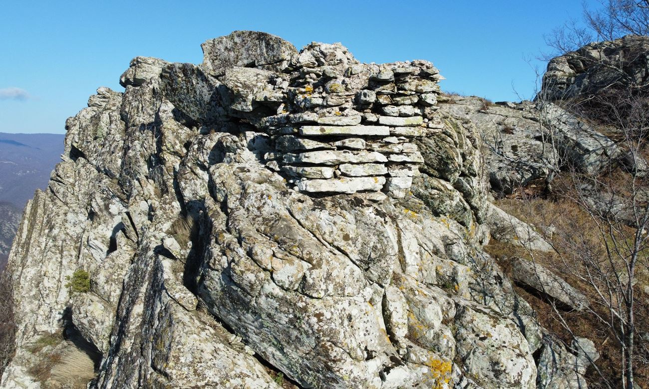
Parts of the wall that fill the gaps between the rocks are preserved from the fortress. There is fortification of this type around the summit (photos 1,2,3), but also at the base of the rock of the summit.
Most of these fortification walls are made of stones of different sizes with a binding mortar between them and a few ceramics.
The total perimeter of the fort is 150-200 meters.
The most characteristic surviving wall is at the top. It is a section 3 meters long, 1.30 m thick and about 1.5 m high which literally hangs from the rock and is held there by the binding material between the stones.
At the base of the rock, the walls (which in some places are dry stone) follow the rugged and fairly sloping terrain on the south side. Here a section of wall about 5 meters with a thickness of 1.30 stands out at a low height. Directly below the wall are piles of stones, apparently from parts of the wall that have collapsed.
There is no wall on the northern side of the hill, because this side is well protected by the vertical rocks.
In the area there are abundantly scattered ceramics which, as mentioned, have a diachronic origin.
It is worth mentioning that 400-500m. before the castle, along the ridge from Machaira outpost to the castle, there are remains of another wall without connecting material (dry stone) and some remains of rectangular buildings and scattered ceramics.
| First entry in Kastrologos: | January 2023 |
Sources
- Research, info and photos by Sakis Amfitreidis and his blog ΑΜΦΙΤΡΕΙΔΗΣ (January 2023)
- ΑΡΧΑΙΟΛΟΓΙΚΟΝ ΔΕΛΤΙΟΝ-τεύχος 33 (1978) - Β’ 2-ΧΡΟΝΙΚΑ, σελ. 308
- Website ΘΡΑΚΙΚΟΣ ΗΛΕΚΤΡΟΝΙΚΟΣ ΘΗΣΑΥΡΟΣ - Θάμνα (βυζαντινή εποχή)
|
|
| Access |
|---|
| Approach to the monument: |
| Approach through Machaira border guardpost where we arrive after a half hour drive on an uphill but passable dirt road that starts from Thamna. From there, we walk to the top at the east for 1km without a path. |
| Entrance: |
| Free access but difficult. |
| Other castles around |
|---|
| Fortress of Gratini |
| Komotini Walls |
| Castle of Linos |
| Mosynopolis |
| Fortress of Nymfea |
| Castle of Polyantho |


