

Agra, Dytiki Lesbos, Lesbos,North Aegean
Chalandrokastro


| Location: |
| On a rocky hill 2 km SW of the village Agra in Lesbos island, on the road to Mesotopos |
| Region > Prefecture: |  |
| North Aegean Lesbos | |
| Municipality > Town: | |
| City of Dytiki Lesbos • Agra | |
| Altitude: | |
|
Elevation ≈ 475 m (Relative Height≈160 m) |
| Time of Construction | Origin | |
| Middle Byzantine period | BYZANTINE |
|
| Castle Type | Condition | |
| Castle Ruins |
In Ruins
|
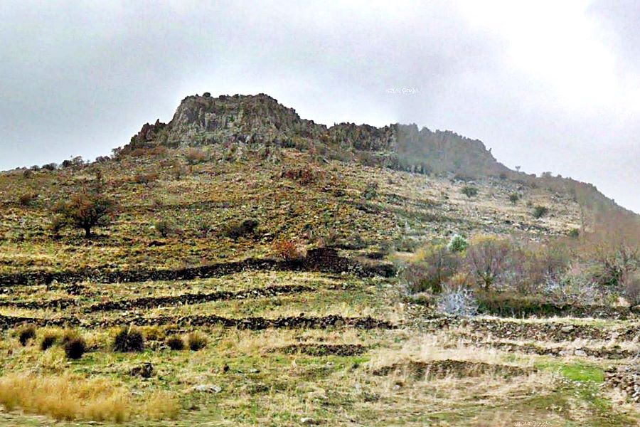
Remains of a medieval fortification on a rocky hill located in a deserted area 2 km southwest of Agra in Lesvos, very close to the road to Mesotopos.
History
The fortification is medieval but of undetermined date, presenting similarities with other undated and ruined castles in the interior of Lesvos, such as Agiasos, the castle of Stypsi etc.
These fortifications, for which there are no reports from historical sources, seem to have been originally built in the mid-Byzantine period, probably in the Dark Ages (between the 7th and 9th centuries), when Saracens and other pirates began to plunder the Aegean. These castles continued to be used at least until the Genoese period of the Gatelouzι (1355-1462), since in some of them, such as Agiasos, the Genoese additions are obvious.
Chalandrokastro seems to belong to this category with a more probable time of construction somewhere between 7th and 10th century AD. This hypothesis is supported by abundant ceramic finds from the mid-Byzantine period.
However, there are traces of habitation in the area during the Early Bronze Age and also during the ancient classical period. It was probably in use until the Gatelouzi period when the alum trade (a product of the region) was in full bloom. Later it was probably abandoned as during the Turkish period when the danger of raids disappeared (as the robbers and pirates were the Turks until then), there was no reason to protect the routes inside the island, while the need for the population to stay on steep rocks had become obsolete. Therefore, Chalandrokastro must have been abandoned during the first period of Turkish rule, at the latest.
Structure, Fortification & Buildings
Chalandrokastro is built on a narrow plateau on the NE-SW axis, 180m long and 40 meters wide, at the top of the hill protected by vertical rocks.
The castle dominates the extensive area of Kontisia, to the east, from where the precious Alum was mined since ancient times. The ore had various uses in tanning, dyeing fabrics, medicine, cosmetology, etc.
In Kontisia there was a settlement during the Middle Ages with 118 houses that does not exist now.
Part of the eastern wall of the castle is preserved. It is a strong wall 2 meters thick made of cobblestones and mortar. There are traces of the wall on the other sides, but logically there should be no fortification along the entire perimeter because the steep cliffs provided adequate natural protection.
In the middle of the plateau there are the remains of a large cistern measuring 9.16✖5.61 meters and 2.5 meters deep.
| First entry in Kastrologos: | October 2021 |
Sources
- Article and photos by Makis Axiotis in the web site emprosnet - Τα Κάστρα της Λέσβου μετά την Άλωση του 1462 H’,23/09/2021
- Info by Emmanouil Apergis
|
|
| Access |
|---|
| Entrance: |
| Free access |
| Other castles around |
|---|
| Vigla of Eresos |
| Palaiokastro of Kalloni |
| Tower of Lisvorio |
| Castle of Mithymna |
| Ovriokastro |
| Tower of Parakoila |
| Sigri Castle |
| Kastreli of Stypsi |
| Paliopyrgos of Vrisa |


