

Proti, Trifylia, Messenia,Peloponnese
Fortification of Proti


| Location: |
| In the southern part of island Proti, offshore the village Marathopolis in Messinia, Peloponnese |
| Region > Prefecture: |  |
| Peloponnese Messenia | |
| Municipality > Town: | |
| City of Trifylia • Proti | |
| Altitude: | |
| Elevation ≈ 60 m |
| Time of Construction | Origin | |
| Various periods | ANCIENT |
|
| Castle Type | Condition | |
| Castle Ruins |
In Ruins
|
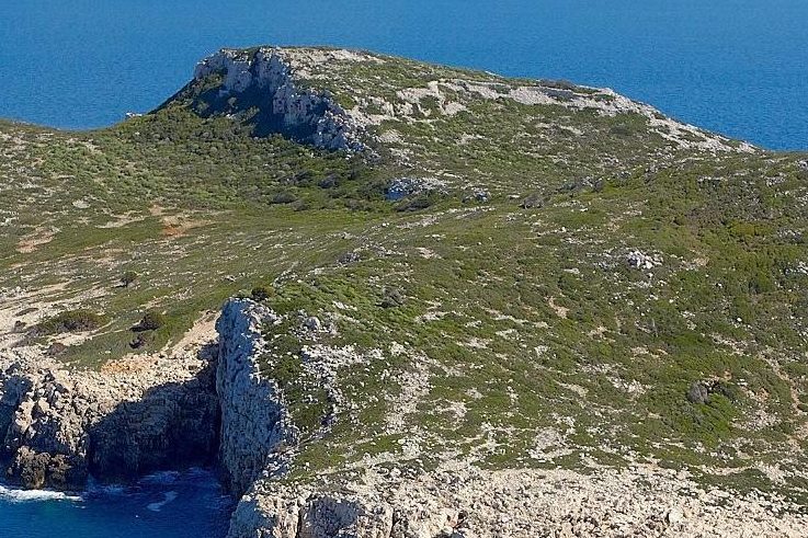
Extensive fortification ruins on the uninhabited islet Proti in the southern Ionian Sea, offshore the village of Marathopolis in Trifylia, Messinia. The fortification enclosed an ancient settlement and was in use for many centuries, until the end of the Middle Ages.
Location & Strategic Scope
The fortification is located in the southern part of the island, on an elevated plateau, 60 meters above sea level. This is the narrowest point of Proti with direct supervision and access to two small ports - one on the west coast and the other on the east coast. The ports are very small, but their existence and the fact that the ships in ancient times could very quickly sail around the small island and be on the leeward side, made the island suitable for anchorage. On the west side the anchorage is larger but not protected from the south and west.
The Name of the Castle
Proti means “first” and perhaps was named like this because it is the first land seen by the sailors from afar to the Peloponnese.
Another explanation is that the name comes from the ancient demon Proteus
Usually, one has to be very sceptical of local names claiming origin from ancient or mythical heroes. Here, however, the mythological origin is extremely probable, since the most common depictions of Proteus show him with a snake tail. And the islet, indeed, is shaped like a reptile with a tail.
This name has existed since antiquity. Later, various sources and portolani of the late Middle Ages mark the island with names such as Prothi, Prothis, Prondano, and others similar derived from the ancient name.
History
The island of Proti is uninhabited today, but until relatively recently it was inhabited. Until the 2001 census, a few inhabitants were mentioned. They were probably fishermen or perhaps monks in the monastery of the Assumption of the Virgin. In the past, it seems that there were more inhabitants who lived in a settlement inside and below what we call here “Fortification of Proti”.
The little ports of Proti were definitely in use – if nothing else as a refuge – in antiquity and the Byzantine period. This is evidenced by about 30 inscriptions on the rocks of the coast with wishes for a good and safe trip, belonging to the post-classical, Roman and Byzantine eras.
Proti is mentioned by Thucydides, who reports that the Athenian fleet of Demosthenes (the general, not the orator) found refuge there, due to bad weather, before besieging the Spartans on the island of Sfaktiria. This happened around 425 BC in one of the most characteristic episodes of the Peloponnesian War.
Proti is also mentioned by Strabo. The next reference from a historical source is during the Frankokratia, in 1361, when it is included in the letter of Nicolas de Boyano to Mary of Bourbon, widow of Roberto di Taranto, with an inventory of the princess's possessions in the Peloponnese.
A little later, Prothi is among the fiefs granted by Amédée de Savoie to his Greek supporter Ioannes Laskaris Kaloferos, according to a document of 1387. This Amédée was the grandson of Philip of Savoy who was the third husband of Isabelle Villehardouin and thus became Prince of Achaea. Amédée was trying to secure his hereditary title of Prince of Achaea by granting fiefs he did not actually have.
In the 17th century, the Turkish traveler Evliya Tselepi makes a brief reference to Proti by writing that the island that the Franks call Pradana is inhabited.
As far as we know, the fortification in Proti has never been the subject of archaeological research, although it could hide interesting findings. From the form of the ruins and the few references from the sources, we can assume without absolute certainty the following:
In Proti there was from ancient times a settlement that was protected by fortifications. The settlement continued to be inhabited - perhaps not continuously and certainly not by a large population. During the Frankokratia (13th-15th cent.) there was a settlement which continued to be protected by the ancient fortification with some minimal additions. (However, the Frankish references above do not mention a castle, only a village). In the first centuries of Ottoman rule, habitation continued with the population constantly declining.
Structure, Fortification & Buildings
The fortification of Proti, the perimeter of which in its original form was about 500 meters, includes an area of 12,000 sq.meters.
The northwest side is steep with rare traces of walls (it may not have been completely walled). In the other sections, the walls are preserved along their entire length, at a low height. In some places the preserved height reaches 3 meters.
The construction of the walls is made of processed stones of various dimensions without mortar. The masonry could be described as isodomic in some places only, obviously in the older parts of the fortification.
On the slope south and southeast of the citadel there are traces of a settlement.
The “citadel” is divided into two parts by a wall in the middle. The northeast which is a little bigger and the southwest which is lower.
A little further north of the fortification two natural coves are formed at the coast. They would offer some protection to small ships, but they are not suitable for all winds, and are of limited capacity.
On the island there is also the monastery of the Assumption of the Virgin Mary (in good condition) which is closed all year round except the 15th of August. It is alleged that it was built on the site of an older monastery or church.
On the east coast, above the small port and outside the main fortification, there is a rocky peninsula at the base of which are the foundations of an ancient circular tower built with the isodomic system. The average preserved height is about 1.5 meters. The original outer diameter seems to have been about 10 meters. Apparently the tower was there to protect the port, and judging by the size of its base, it was a massive tower. Its stone structure seems older of that of the main fortification.
| First entry in Kastrologos: | April 2021 |
Sources
- Photos: ΕΚΠΟΛΙΤΙΣΤΙΚΟΣ ΣΥΛΛΟΓΟΣ ΜΑΡΑΘΟΠΟΛΗΣ - σελίδα Facebook, 2020
- Antoine Bon, 1969, La Morée franque. Recherches historiques, topographiques et archéologiques sur la principauté d'Achaïe (1205-1430), Editions de Boccard, pp.258, 428, 431
- Γεώργιος Παπανδρέου, Η ΝΗΣΟΣ ΠΡΩΤΗ (Εν τω νυν νομώ Τριφυλίας), 1902
visit 29/5/1899 - Website Αριστομένης ο Μεσήνιος - Νήσος Πρώτη- Τριφυλία
- Info: Yorgos Costopoulos
|
|
| Access |
|---|
| Approach to the monument: |
| By boat from Marathopolis, |
| Entrance: |
| Free access |
| Other castles around |
|---|
| Castle of Iklaina |
| Castle of Kyparissia |
| Niokastro |
| Palaiokastro |
| Tower at Limni Papa |
| Castle of Raptopoulo |
| Castle of Voutaina |


