

Malandreni, Argos-Mycenae, Argolis,Peloponnese
Tower of Skala of Malandreni


| Location: |
| On a low hill at the location Skala south of the villlage Malandreni in Argolis, 100m from the road Nemea-Argos |
| Region > Prefecture: |  |
| Peloponnese Argolis | |
| Municipality > Town: | |
| City of Argos-Mycenae • Malandreni | |
| Altitude: | |
|
Elevation ≈ 125 m (Relative Height≈20 m) |
| Time of Construction | Origin | |
| Unknown | BYZANTINE |
|
| Castle Type | Condition | |
| Ruined Tower |
In Ruins
|
Remains of a big medieval tower on a low hill at the location “Skala” or “Kastro” on the upcountry road Nemea-Argos, between the villages of Malandreni and Koutsopodi in Argolis.
History
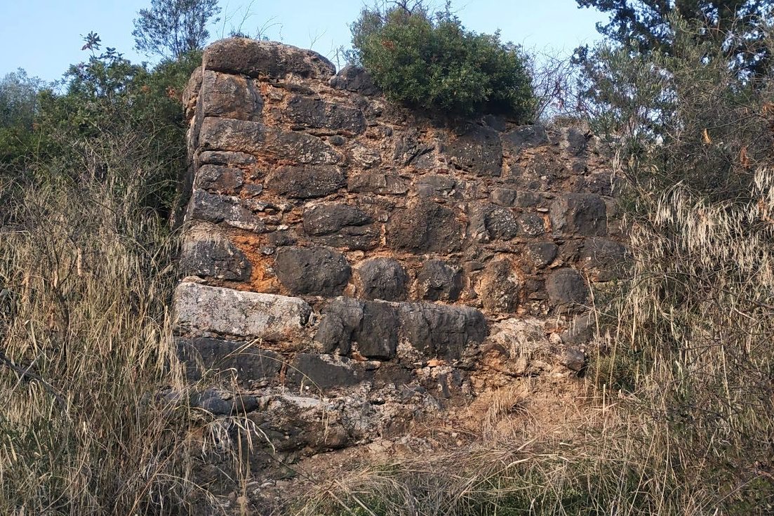
The history of the tower is unknown. The way of construction shows that it was either an ancient tower that received modifications during the Middle Ages or, most likely, it was a medieval tower that was built with materials from ancient buildings.
Its masonry consists of large blocks with additions, mainly at the top, of smaller semi-finished stones. A bonding mortar with fragments of ceramics has been used in the intermediate gaps. The style is reminiscent of a Byzantine tower and that is why we will characterize it "Byzantine", although this is not absolutely certain. It could be Frankish.
Today, most of the tower is covered by soil and dense vegetation. Only its south side and part of the west side are visible. In an older photo of the archeological bulletin from 1971 (photo 5) the tower can be seen better, but otherwise it does not seem to be in much better condition than today.
Structure, Fortification & Buildings
The south side of the tower is 9 meters long. From the west side, a section around 6 meters is visible, while the rest is buried. The maximum surviving height is around 3.5 meters.
The tower has visual contact with the castle of Argos (Larissa) from which the air-distance is 8.5 km.
| First entry in Kastrologos: | March 2022 |
Sources
- Blog ΑΜΦΙΤΡΕΙΔΗΣ - ΑΡΧΑΙΟΣ ΠΥΡΓΟΣ ΣΤΗ ΣΚΑΛΑ ΜΑΛΑΝΤΡΕΝΙΟΥ (Ν.ΑΡΓΟΛΙΔΟΣ) (November 2019)
- ΑΡΧΑΙΟΛΟΓΙΚΟΝ ΔΕΛΤΙΟΝ, τεύχος 26-Β1, 1971, p.83
|
|
| Access |
|---|
| Approach to the monument: |
| The hill is on the upcountry road Argos-Nemea, just after the chapel of Agia Kyriaki. |
| Entrance: |
| Free access |


