Koumaritsi, Lamia, Phthiotis,Central Greece
Siderokastro of Oeta
or Castle of Kouvelos or Castle of Oria
| Location: |
| On mount Kouvelos overlooking the Asopos gorge, NE of the village Pavliani in mount Oeta in Central Greece |
| Region > Prefecture: |  |
| Central Greece Phthiotis | |
| Municipality > Town: | |
| City of Lamia • Koumaritsi | |
| Altitude: | |
|
Elevation ≈ 730 m (Relative Height≈400 m) |
| Time of Construction | Origin | |
| 13th cent. | Late-BYZANTINE  |
|
| Castle Type | Condition | |
| Castle Ruins |
In Ruins
|
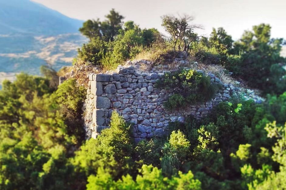
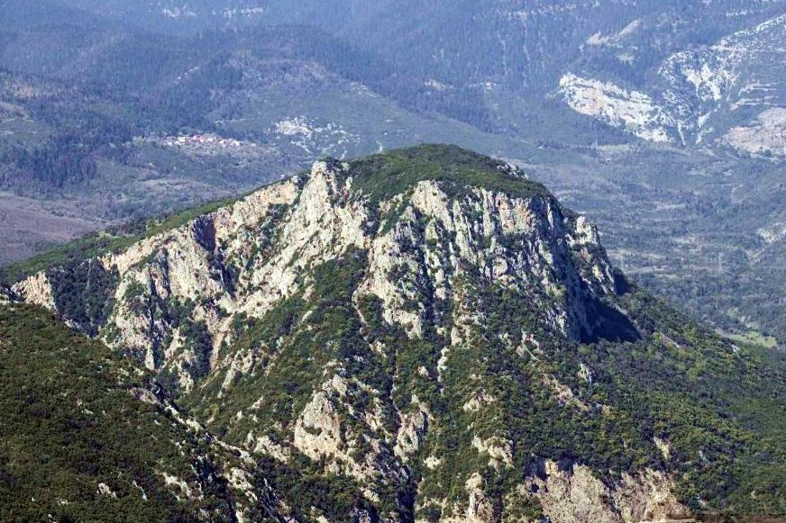
Remains of a medieval castle on the summit plateau of an impressive hill known as “Kouvelos”, overlooking the gorge of the Asopos River, near the villages of Koumaritsi and Pavliani on Mount Oeta.
Koumaritsi is geographically closer to the castle, to its west, but the recommended hiking approach is from Pavliani, which is about 4 km southwest of the castle. Another hiking route starts from the old Asopos railway station and follows the railway line westward.
Location & Strategic Scope
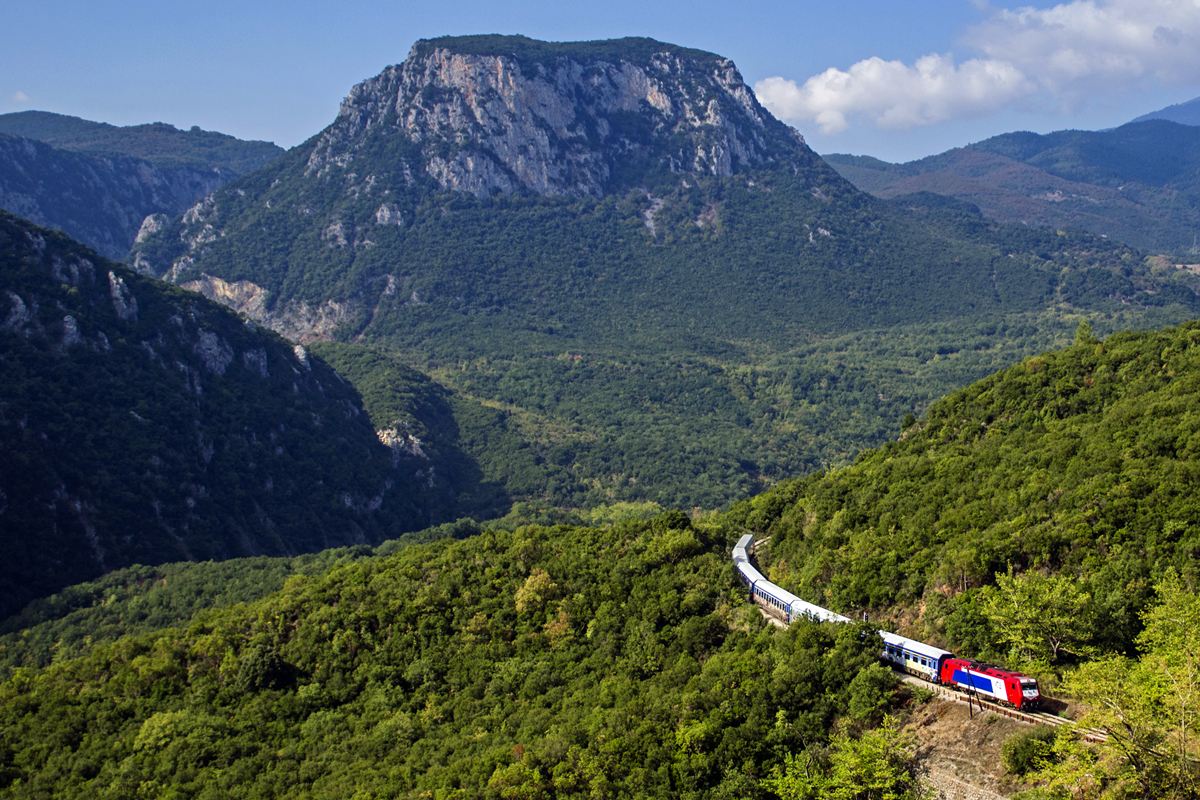
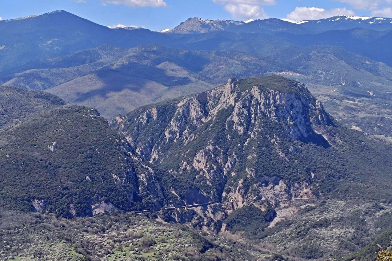
Kouvelos is a spur on the northern side of Mount Oeta, with an elevation of 730m. The steep slopes of Kouvelos, combined with the river and the gorge below, provided the castle with excellent natural protection. Access to the site was possible –with a difficult climb– only from the northern side of the hill.
To the southeast, there is a line of sight toward Mount Kallidromon, while to the northeast there is good visibility across the Spercheios Valley as far as the sea and the Maliac Gulf. In the other directions, visibility is limited by the intervening peaks of the Oeta mountain range.
The site’s main strategic advantage was control of the Asopos Gorge, which provided an alternative route to southern Greece. (The other –and better-known– route was that of Thermopylae, farther east.)
It is believed that the notorious Anopaia Atrapos began in the Asopos Gorge (that was the secret trail by which Ephialtes led the Persians around the rear of the Spartans defending the pass at Thermopylae).
The narrowest point of the Asopos Gorge lies directly below the castle. It is an impressive passage only a few metres wide, where two almost vertical rock faces rise high on either side. This narrow pass may have been the “Sideroporta” (“Iron Gate”) mentioned in the Chronicle of Morea, and its name may perhaps be etymologically related to the castle above.
Kouvelos and the Asopos Gorge form part of a geological formation of steep cliffs and hills that extends as far as Thermopylae (12 km farther east), which Herodotus calls the Trachinian Rocks. In antiquity, the wider area –on the northern foothills of Mount Oeta, between Gravia and Thermopylae and south of the Spercheios– was known as Trachinia. The name derives from the Mycenaean city of Trachis, which existed in the area.
Below the castle, to the east of Kouvelos, runs the former Tithorea–Lianokladi railway line, which passes through the Asopos Gorge. The line is no longer used for regular traffic following the construction of a new line in 2023. The old line remains intact, as does the railway bridge below the castle.
History
The medieval Siderokastron of Oeta is mentioned exclusively in Frankish sources. Specifically, it is mentioned in the French and Aragonese versions of the Chronicle of Morea, in the historiography of the Venetian Marino Sanudo, and in Catalan documents of the 14th century.
The Byzantine historian G. Kolias (1933) believed that the castle was also mentioned in the Greek Chronicle of Morea, in the passage referring to the northward campaign of the Frankish army in 1259 under the leadership of William II Villehardouin, shortly before his disastrous defeat at the Battle of Pelagonia. The relevant verse reads:
They crossed the Sideroporta straight on and found the prince further inside in Vlachia [Thessaly].
However, Sideroporta clearly refers to a passage, not to a castle, and the conclusion that the verse refers to Siderokastron is arbitrary. It is possible that the passage does indeed refer to the narrow gorge of the Asopos below Siderokastron, but the verse in the Chronicle in no way provides evidence for this hypothesis.
It should be noted that the same incident, and the Sideroporta, are also mentioned in the French Chronicle.
If we therefore reject this theory, the existence of the castle is first mentioned in 1275 (more on this below). This was obviously not the date when it was founded, however. It certainly existed earlier.
It is possible that a Byzantine fortress or an ancient city already existed on the site of the medieval Siderokastron. As for identifying the castle with an ancient city, there is some confusing information online (and in the bibliography as well), and several points need to be clarified:
Identification of the castle
As mentioned above, during the Mycenaean period there was a city called Trachis or Trachina in the area, belonging to the Malians.
The city is mentioned in the Iliad, in the Catalogue of Ships, as having participated in the Trojan War with 50 ships under the command of Achilles.
Some believe that the ancient Trachis stood on Kouvelos, that is, that it was Siderokastron. This cannot be ruled out, but it is probably not the case.
In 426 BC, during the Peloponnesian War, the Spartans founded Heraclea in the area, which became known as Heraclea in Trachinia or Heraclea Trachinia. Its remains are located about 6 km northeast of Kouvelos, near the present-day village of Heraclea (formerly “Boustafa Bey”). That city, which had walls and an acropolis, survived until the end of the Hellenistic period, but had already been abandoned before the 1st century AD.
Strabo states that Trachis was only six stadia from Heraclea Trachinia, that is, less than one kilometre. If the distances given by Strabo are accurate, this means that the Heraclea of the 5th century BC stood almost on the site of the Mycenaean Trachis.
What, then, is the relationship between Trachis and Heraclea and Siderokastron, apart from their geographical proximity?
Earlier scholars, such as Neroutsos and Kolias, identified ancient Trachis with Siderokastron on the summit of Kouvelos, relying mainly on Pausanias’ statement that Trachis stood on a steep hill. This view is no longer widely accepted, for the following reasons:
First, the location of Kouvelos does not correspond to the distance of six stadia from Heraclea given by Strabo. Second, it does not correspond to the distance of 40 stadia (7 km) from Thermopylae mentioned by Herodotus. Third, the castle is quite far from the sea, which poses a problem for the Trachis of the Iliad, which is presented as participating in the expedition against Troy with 50 ships. Finally, no ancient remains have been found on Kouvelos. (The latter, however, is a weaker argument, since no excavations have been carried out.)
In any case, the most likely location of Mycenaean Trachis is very close to the later Heraclea Trachinia, and not Kouvelos. Siderokastron therefore cannot be identified with Heraclea Trachinia. There remains, however, a small possibility that it occupies the site of ancient Trachis, although the available evidence is insufficient to substantiate this.
Finally, another possible identification is with the ancient city of Omilos or Omilai, mentioned in the Geography of Ptolemy.
Regardless of the question of ancient Trachis, there is another point that requires caution: we cannot be absolutely certain that the castle on Kouvelos is indeed the Siderokastron of the historical sources.
Earlier researchers, such as Bushon and Hopf, placed Siderokastron at different locations in Central Greece. The first to equate the Siderokastron of the sources with the castle on Kouvelos was Kolias, in 1933. The identification was based mainly on descriptions in the historical sources, according to which the castle stood above the Asopos Gorge, approximately halfway along the route from Gravia to the Spercheios.
Since no other fortress is known in this area that corresponds to the historical descriptions, the identification of the Kouvelos Castle with the Siderokastron of the Frankish sources appears plausible. Nevertheless, it is best to regard it as a very probable and well-supported, but not absolutely certain identification.
The Late Byzantine history of the area and Siderokastron
After the capture of Constantinople by the Latins in 1204, Central Greece fell into the hands of the Franks. Very soon, however, from 1210 onward, the Despotate of Epirus began gaining territory from the Franks. In 1218, Constantine, brother of the then Despot of Epirus Theodore I Komnenos Doukas, campaigned in Phthiotis and captured Zetounion (Lamia) and Neopatras (Ypati), which belonged to the Duchy of Athens.
The territory of the Despotate thus reached as far as Oeta and must have included Kouvelos, which now found itself on the border with the Franks. At that time Kouvelos probably did not yet have a castle; it was most likely built somewhat later.
Fifty years later, in 1268, following the death of the Despot of Epirus Michael II Doukas, the Despotate broke up. John I Komnenos Doukas, son of Michael II, established his own semi-independent principality, which included territories in southern Thessaly and Phthiotis. The capital of the new state, known as “Vlachia”, was Neopatras (modern Ypati).
John Doukas was formally a vassal of the Byzantine emperor and even held the title of Sebastokrator. In practice, however, he was independent and eventually came into conflict with the emperor Michael VIII Palaiologos. In 1274 the emperor sent an army against him, which besieged him at Ypati. According to Marino Sanudo, John Doukas asked for the assistance of the Duke of Athens, John de la Roche, who sent him 500 knights. They launched a surprise attack on the Byzantine camp and put it to flight.
After this, John Doukas and John de la Roche sealed their alliance through the marriage of John's daughter, the famously beautiful Helen Angelina Komnene, to William, the brother and heir of the Duke of Athens. As her dowry, John Doukas granted the Duchy of Athens, in 1275, 4 castles: Gravia, Zetounion (Lamia), Gardiki (Pelasgia), and Siderokastron.
This is the first confirmed historical reference to Siderokastron.
Siderokastron obviously existed long before this development. There is no information at all about its existence in earlier centuries, so it is most likely that it was built during the first decades of the 13th century by the Byzantines of the Despotate of Epirus. Its obvious purpose was to control the border with the Franks and the passage through the Asopos toward and from southern Greece. It also provided additional protection for the nearby castle of Ypati (15 km to the northwest), which was at that time the most important castle of Vlachia.
In 1294, the new Duke of Athens, Guy II de la Roche, donated 13 castles to his Lombard friend and mentor Bonifacio da Verona. Among them were Zetounion and Siderokastron.
In 1303, Anna Palaiologina, ruler of the Despotate of Epirus and widow of Despot Nikephoros, attempted to expand her territory by capturing the castle of Fanari. This provoked a reaction from the Duke of Athens, Guy II de la Roche, who marched against her and sought assistance from the other Franks. The French chronicle narrates that the duke waited reinforcements from Achaea for a week at the river below Siderokastron.
In 1311, the marauding Catalan Company defeated the rest of the Franks of Greece at the Battle of Kephissos. Thus, the Duchy of Athens fell into the hands of the Catalans, who ruled it for almost 80 years. During this period, the title of Duke of Athens was held by the king of Sicily, a member of the royal house of Aragon, and he was represented in Athens by a Vicar-General (Viccario). The new Catalan rulers did not disturb Bonifacio da Verona, who retained his fiefs, including Siderokastron, under a degree of autonomy.
In 1317, the Aragonese Alfons Frederic d’Aragó or “Fadrigos” to the Greeks, was appointed Viccario of the Duchy of Athens and almost immediately married Maroula, daughter of Bonifacio da Verona. Through the marriage, he received as dowry many of his father-in-law’s castles, including Siderokastron.
From then on, Siderokastron belonged to the Frederic family. In 1318–1319, taking advantage of the collapse of the principality of Vlachia following the death of its last Greek ruler, Alfons seized other castles, including Ypati and Pharsala. He also acquired the County of Salona as his personal fief, directly subject to Sicily rather than to the “Duchy of Athens and Neopatras”.
Alfonso Frederic's rule lasted until 1330, and this was a period of prosperity both for the Catalan duchy and for Siderokastron.
In the new structure of the duchy, the most important towns (universitates) were the five: Athens, Livadeia, Thiva, Ypati, and Siderokastron, while Zetounion and Amphissa were also important but were personal fiefs of Frederic.
The fact that Siderokastron was included among these otherwise long-established important towns indicates that it was a significant castle. It may also mean that a number of Catalan families had settled there.
After the middle of the 14th century, the duchy entered a period of endless crisis, with intense internal disputes and rivalries among the nobles and frequent changes of vicars. The situation was worsened by dynastic disputes in the Kingdom of Sicily and by the growing Turkish threat, which created considerable insecurity in the duchy.
In this atmosphere of crisis, under unclear circumstances, the Frederic family lost Siderokastron, which passed into the possession of a certain Armengol de Novelles. Armengol attempted to become independent, but was defeated, and around 1359 Siderokastron returned to the Frederics. Shortly afterwards, in 1361 or 1362, Siderokastron was captured by Albanians, who after 1358 had established control over much of Epirus and southern Greece. In 1365 the young Count of Salona, Louis Frederic (grandson of Alfons), recaptured Siderokastron.
In 1367, however, the Sicilian Nicolau de Sosa was appointed lifetime castellan of Siderokastron, although the Frederics continued to hold legal ownership of the castle.
As the crisis deepened, in 1375 the nobles of the duchy elected Louis Frederic as the new vicar. This decision presented the King of Sicily, Frederick III, with a fait accompli, and he was forced to approve it.
After the death of Frederick III in 1377, Louis Frederic helped Peter IV of Aragon claim the crown of Sicily. Following Peter IV's victory, Louis asked him to grant him the County of Malta, Aegina, and Siderokastron, on the grounds that they had long been family fiefs and had been unjustly taken away from them. Peter IV agreed, and Siderokastron returned to the Frederics.
Louis Frederic died in 1382. He was married to Helena Kantakouzene, daughter of John VI Kantakouzenos, and they had one daughter, Maria. Maria inherited the County of Salona by right and probably her father's other possessions as well. With regard specifically to Siderokastron, however, Peter IV stipulated that Maria would receive it only if she married the new vicar of the Duchy, Bernat de Rocabertí.
The marriage did not take place, and we do not know what happened to Siderokastron, since this was the last time the castle was mentioned.
There is no further information about Siderokastron after 1382. Catalan rule in the Duchy of Athens ended in 1388, and the last castle, Ypati, was captured by Nerio Acciaioli in 1390. Siderokastron probably fell into Acciaioli's hands around the same time, but very soon afterwards, sometime during the 1390s, it must have been captured by the Turks.
Logically, settlement at Siderokastron probably continued during the early years of Ottoman rule, but not for very long.
Structure, Fortification & Buildings
Τhe castle has never been systematically surveyed. The latest publications about it date back to before 1940!
Nevertheless, it has been declared an archaeological site: “Hill of Kastro Orias (remains of the ancient city of Omiles or Trachina)” since 2011.
We do not have much information regarding the layout of the castle or what exactly is preserved.
Byzantinist Georgios Kolias, who visited it in 1932 (!), describes it as follows:
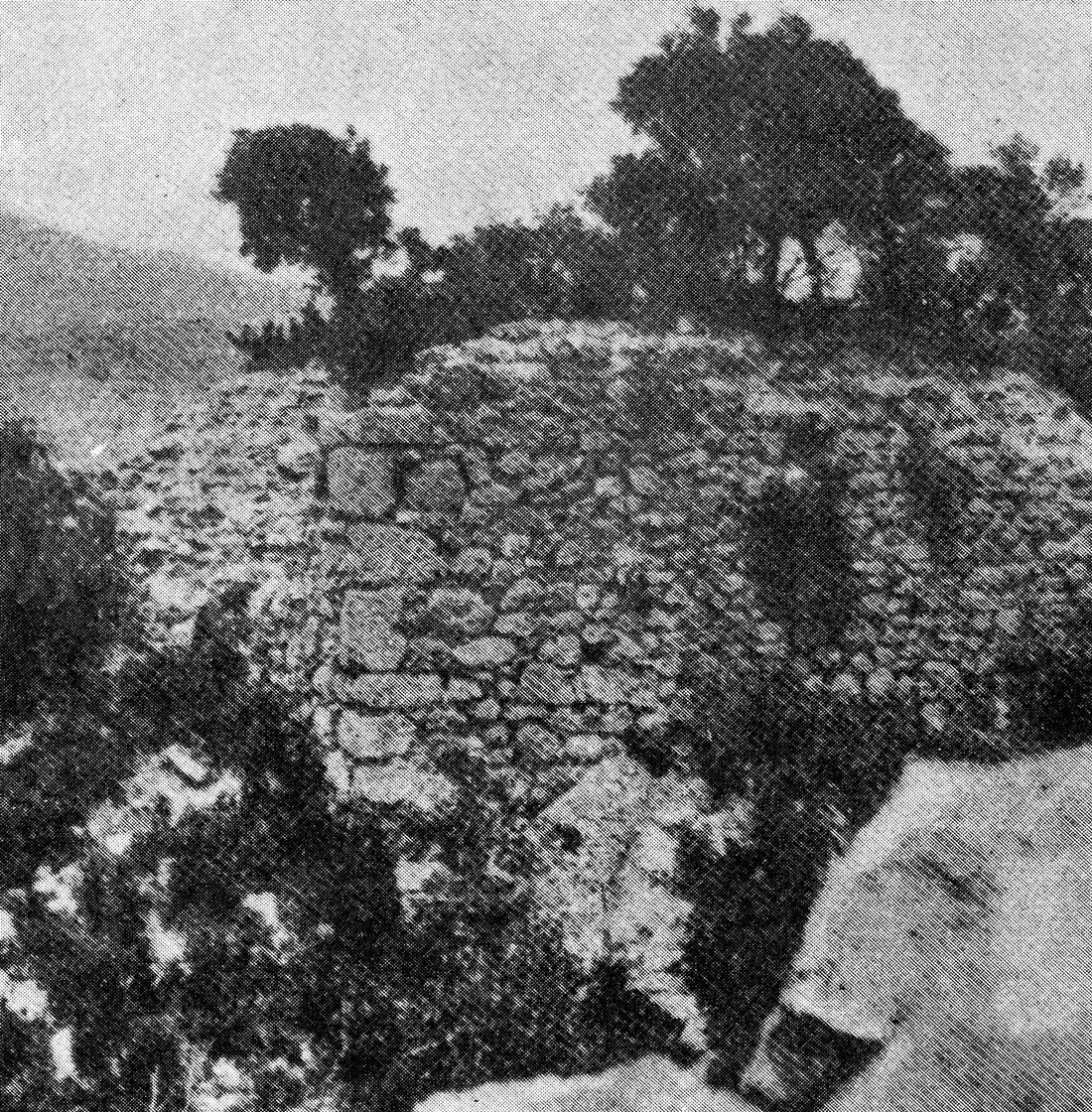
The summit of the hill is flat, forming an extensive plateau, half of which is cultivated, while the other half is covered with shrubby kermes oaks. It is accessible from only one side, the northern one, which is rather smooth, yet fairly steep. As we ascend from Kouvelos, on the right at the northern edge of the plateau, upon a rock, there survive the remains of a medieval fortification –as indicated by its masonry– consisting of a double enclosure. The outer one, which is also the most ruined, is two-sided, as the other two sides are replaced by a steep cliff. Within this enclosure and at the top of the rock, there remain the traces of a tower (photo 1). [...] The area is full of fragments of tiles and stones from collapsed houses, the former existence of which is evident. This certainly proves that Siderokastro was not merely a fortress, but also a settlement. Likewise, within this area survives an underground cistern, situated among the ruins of the buildings, which was filled with rainwater gathered from roofs and courtyards. Its mouth resembles that of a well, and its inner surface is coated with a layer of lime mortar. Finally, its overall shape is pear-shaped.
Béquignon (1937) adds the following information:
On the southern side [above the gorge] stands a strong watchtower, which provided a view of all the surrounding mountains. The southern slope descends in terraces supported by retaining walls.
To the southwest lies a small fort facing inward; on the outer side, a precipitous slope renders a wall unnecessary. A square tower —modified in later times, measuring 3.5 to 4 meters in height and 10m per side— protected the gate. Lastly, scattered across the site are stones from other structures (houses?), suggesting that the acropolis served not only a military purpose but was also inhabited.
There is no more recent information.
| First entry in Kastrologos: | September 2026 |
Sources
- Γεώργιος Κόλιας (1933), Το Σιδερόκαστρον, Επετηρίς Εταιρείας Βυζαντινών Σπουδών, τόμος 1ος. σ.72-82.
- Τάσσος Δ. Νερούτσος (1889), Χριστιανικαί Μελέται: Ιστορική και αρχαιολογική μελέτη. Τυπογραφείον αδελφών Περρή. Αθήνα.
- Antoine Bon (1937). Forteresses médiévales de la Grèce centrale. Bulletin de correspondance hellénique 61: p.139–142.
- Ιωάννης Σφηκόπουλος (1981, Μεσαωνικά Κάστρα και Πύργοι στη Ρούμελη. Αθήνα.
- Ρουβιό υ Λιούκ Α. (RUBIO-I-LLUCH ANTONIO - 1912). Περί των Καταλανικών Φρουρίων της Ηπειρωτικής Ελλάδος (µτφρ. Μαυράκη Γ.Ν.). Αθήνα: Κουλτούρα [1991].
- Yves Béquignon (1937), La vallée du Spercheios des origines au IVe siècle, Bibliothèques de l'Ecole française d'Athènes et de Rome - Série Athènes, 144. p.243-263
- Αλέξανδρος Καλαντζής , ιστοσελίδα Κάστρα της Ελλάδας, κάστρο Ωριάς, Κουμαρίτσι (φωτο 1)
- Έρευνα και πληροφορίες: Γιώργος Χανδρινός
| Access |
|---|
| Entrance: |
| Free access. |
| Other castles around |
|---|
| Tower of Amfikleia |
| Castle of Kastellia |
| Castle of Lamia |
| Tower of Lilaia |
| Tower of Madamia |
| Kastri of Makrakomi |
| Castle of Mendenitsa |
| Castle of Ypati |