

Kastri Loutro, Tempi, Larisa,Thessaly
Castle at Kastri Loutro
1

2 / 19

August 2019
3 / 19

August 2019
4 / 19

August 2019
5 / 19

August 2019
6 / 19

August 2019
7 / 19

August 2019
8 / 19

August 2019
9 / 19

August 2019
10 / 19

August 2019
11 / 19

August 2019
12 / 19

from ERT TV footage, Oct 2018
13 / 19

from ERT TV footage, Oct 2018
14 / 19

team Kastrologos, August 2019
15 / 19

team Kastrologos, August 2019
16 / 19

team Kastrologos, August 2019
17 / 19

Kostas Gertzos, August 2023
18 / 19

Kostas Gertzos, August 2023
19 / 19

Kostas Gertzos, August 2023

THE END
| Location: |
| At the western end of the settlement Kastri Loutro, in the wetland of the delta of Pinios river |
| Region > Prefecture: |  |
| Thessaly Larisa | |
| Municipality > Town: | |
| City of Tempi • Kastri Loutro | |
| Altitude: | |
| Zero Altitude |
| Time of Construction | Origin | |
| 7th or 8th cent. | BYZANTINE |
|
| Castle Type | Condition | |
| Castle |
In Ruins
|
Ruins of a castle located in the wetlands of the delta of Pineios river.
Location & Strategic Scope
The bed of Pineios river changed many times over the centuries, and it is almost certain that, at some point, this was once a coastal fort, although now is 550m from the sea.
The castle was built there for a number of reasons:
a) to protect the port (named “Pindanemo”) that most probably existed there as shown in old maps;
b) to guard the entrance to the river which those days must have been navigable and a major route;
c) to survey the only road from Macedonia to Thessaly and South Greece, which passes a few hundred meters from the castle. All the region along the road from Platamon to the southern exit of Tempi Valley, constituted a clausura of strategic importance, and Kastri was part of its monitoring system.
History
The castle is not recorded in historic sources. So we know nothing about its history and its chronology.
Examining the type of construction, we would risk preliminary dating inside the so called Medieval Dark Ages (7th-8th A.D.)
The use of the castle did not last, probably, for many centuries as the region was overwhelmed by Slavic tribes between the 7th to 10th centuries and the coastline was pillaged often by Saracens in the same period. In any case, in the 10th century, when the nearby Platamon castle was built, the Kastri fort became obsolete.
Structure, Fortification & Buildings
The fort had a rectangular layout measuring 160m.✖80m.
The perimeter was 480m and the total area 13,300 sq.m The thickness of the walls is around 2.40m.
The fort had 9 or 10 square towers of which 3 or 4 were at the corners and bigger than the rest, measuring 10.30✖10.30m.
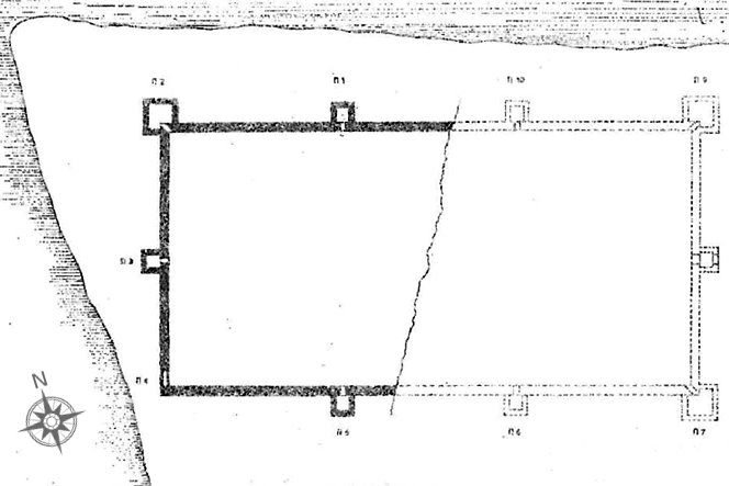
The castle is in ruins and the maximum preserved height of its walls is 2m, while the initial height must have been more than 7m. Remains of only 4 towers are visible today.
The castle was in relatively better position until 1999 when it was vandalized and bulldozed by the owner of the plot!
In 2017 and 2018 the area of the castle was cleaned and parts of the castle unearthed. Unfortunately, the work was not continued in 2019 and the ruins are overgrown again.
| First entry in Kastrologos: | September 2019 | Last addition of photo/video: | August 2023 |
Sources
- Ευάγγελος Αθ. Παπαθανασίου, ΤΟ ΚΑΣΤΡΙ ΣΤΗ ΘΕΣΗ ΚΑΣΤΡΙ-ΛΟΥΤΡΟ, ΒΟΡΕΙΩΣ ΜΕΣΑΓΚΑΛΩΝ, ΚΑΙ Η ΠΕΡΙΟΧΗ ΤΟΥ, Νομαρχιακή Αυτοδιοίκηση Λάρισας, Άγιος Δημήτριος Στομίου: Ιστορία-Τέχνη-Ιστορική Γεωγραφία του Μοναστηριού και της περιοχής των εκβολών του Πηνειού, Επιμ.: Στ. Γ. Γουλούλης – Σταυρ. Τ. Σδρόλια, Λάρισα 2010, σσ. 273-314.
- Footage by ERT TV, Εργασίες ανάδειξης του βυζαντινού κάστρου στον Δήμο Τεμπών, October 2018
- Photos 17, 18, 19 by Kostas Gertzos (August 2023)
|
|
| Access |
|---|
| Approach to the monument: |
| From the center of the village take a road away from the sea, to the west. At the end of the road you reach the castle after crossing on foot a small bridge over a pond. |
| Entrance: |
| Free access |
| Other castles around |
|---|
| Castle of Kokkino Nero |
| Castle of Oria |
| Platamon Castle |
| Tower of Tsiligiorgis |
| Castle of Velica |


