

Erythres, Mandra-Eidyllia, Western Attica,Attica
Tower of Agha
1
2 / 14

photo: Ioannis Dedes, July 2020
3 / 14

photo: Ioannis Dedes, July 2020
4 / 14

photo: Ioannis Dedes, July 2020
5 / 14

photo: Ioannis Dedes, July 2020
6 / 14

photo: Ioannis Dedes, July 2020
7 / 14

photo: Ioannis Dedes, July 2020
8 / 14

photo: Ioannis Dedes, July 2020
9 / 14

photo: Ioannis Dedes, July 2020
10 / 14

photo: Ioannis Dedes, July 2020
11 / 14

photo: Ioannis Dedes, July 2020
12 / 14

photo: Ioannis Dedes, July 2020
13 / 14

photo: Ioannis Dedes, July 2020
14 / 14

photo: Ioannis Dedes, July 2020

THE END
| Location: |
| In a rural area 2km northeast of Erythres in Attica |
| Region > Prefecture: |  |
| Attica Western Attica | |
| Municipality > Town: | |
| City of Mandra-Eidyllia • Erythres | |
| Altitude: | |
|
Elevation ≈ 352 m (Relative Height≈5 m) |
| Time of Construction | Origin | |
| Unknown | FRANKISH |
|
| Castle Type | Condition | |
| Ruined Tower |
In Ruins
|
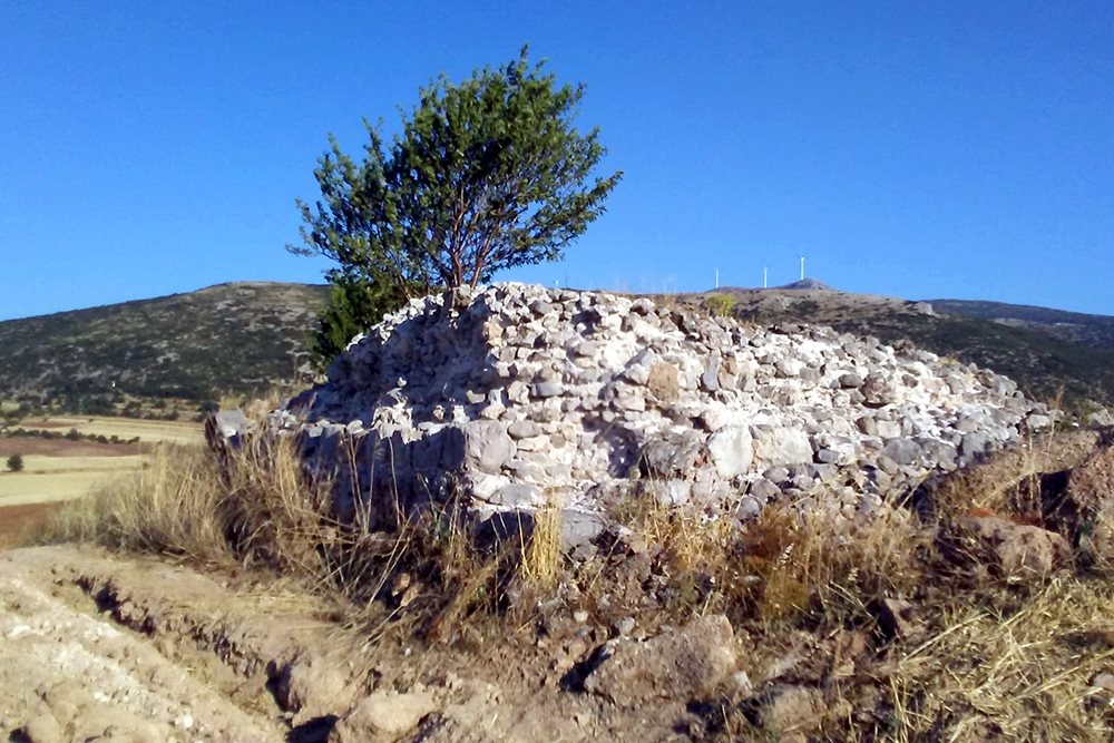
Remains of a medieval tower, 2 km northeast of the town of Erythres (old name “Kriekouki”) at a slightly elevated point, between fields.
The area is on the border of Attica with Boeotia.
History
We do not know the history of the tower. What we can say with some certainty - judging by its name - is that the tower must have been used during the Turkish occupation and was the center of a tsiflik.
The first researcher to mention the tower is Pritchett (AJA, 1957), who found it in the same condition as today, more or less, and who attempts the hypothesis that it was originally rather Frankish without ruling out that it was built on the site of an ancient Greek or Roman tower in which many interventions were made later.
In Kastrologos, we agree that most likely the tower was Frankish since its construction resembles the rest of the Frankish towers in Central Greece. Therefore, during the Frankish rule, it must have been the seat of a fief, one of the many in which the area was divided by the Franks after 1204.
Apparently it was also used during the Turkish occupation by a local Agha. It should be noted that the neighboring tower of Boubouka (“Tower of Spachi”) was used during the Turkish occupation.
In previous decades (before 1950, definately), the tower may have been preserved to a greater height on its southeast side. This uncertain conclusion is based on the existence of a concrete staircase that protrudes from the stone pile of the tower and which is certainly not very old. In other words, we assume that the tower was in use (perhaps as a farm house or military outpost) until the 20th century (perhaps until the Civil War) and then either abandoned and collapsed or - most likely - his materials were used in other buildings.
Structure, Fortification & Buildings
The dimensions of the tower are about 8✖7μ. The tallest preserved part is at the NW wall reaching a 2.85m height..
Its stone structure and the type of construction do not differ from the other towers of Central Greece. Its walls are made of semi-processed stones with a sufficient amount of mortar. Tile fillings are in every part of the building giving it greater stability.
It is worth noting that the lower part of the base is built more carefully, with larger and better processed stones, placed more carefully. This may indicate earlier (ancient?) construction of the tower, but this is something that can not be proven. At the base there is also mortar, but it looks as if it has been added afterwards.
The interior of the tower is full of rubble that collapsed in earlier times. We do not know its initial height or the number of floors, which would be at least two.
| First entry in Kastrologos: | August 2020 |
Sources
- Research, photographs and presentation by Ioannis Dedes
- W. Kendrick Pritchett, American Journal of Archeology, Vol. 61, No. 1 (Jan., 1957), pp. 9-28
|
|
| Access |
|---|
| Entrance: |
| Free access |


