

Aktaion, Karystos, Euboea,Central Greece
Castle of Aktaion


| Location: |
| On a hill south of the village Aktaion (Skouasi) of southern Evia |
| Region > Prefecture: |  |
| Central Greece Euboea | |
| Municipality > Town: | |
| City of Karystos • Aktaion | |
| Altitude: | |
|
Elevation ≈ 540 m (Relative Height≈170 m) |
| Time of Construction | Origin | |
| perhaps 13th cent. | FRANKISH |
|
| Castle Type | Condition | |
| Dry-Stone Fortification |
In Ruins
|
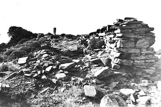
Few remains of a medieval castle on a hill south of the village Aktaion in Karystos region of southern Euboea island.
Location & Strategic Scope
The purpose of a castle at that point -so close to Fylagra- is not very obvious. The name “Skouasi” means “passage” in the Arvanitika dialect, and, perhaps, the castle was protecting the hilly passage to the southern Euboea. Probably the castle also surveyed the little bay at the coast below, which was a temporary anchorage for ships waiting for the right weather to pass the dangerous cape Cavo d’Oro. Another possible reason for its existence is the support of the defense of the nearby important castle of Fylagra.
The Name of the Castle
The old name of the village Aktaion was Skouasi. The castle is presented as Aktaion or Skouasi but this was not its original name which remains uncertain.
Most probably, this was the castle Silosa that is marked in old Venetian maps very close to the Fylagra caste. This comes from Bocca di Silosa (mouth of Silence) which perhaps was the name of the small bay 1.5km north of the castle where the sea is relatively calm (hence the “Silence”) compared to the waters after the nearby cape Cavo d’Oro.
History
The castle has never been researched. Th.Skouras visited in 1974, and is the only source of the photographs and the description of the fortification. Skouras also proposed the plausible theory that this was the Silosa castle of the Venetian maps.
The time of construction is unknown. It is rather a Frankish construction of the 13th century.
In 1312, a peace traty was signed between the Venetians and the Catalans, who had occupied Karystos a few years before. Under the treaty, the Catalans agreed to dismantle the castles of the region. It is known that Fylagra was destroyed then and it is very possible that the same happened to Silosa. This is an explanation why almost nothing is left of this stronghold.
Structure, Fortification & Buildings
The fortification is almost completely destroyed. A part of the wall, 12m-long, 2.5m thick, is still visible at the northern side. There are also scattered ruins of other walls and unidentified constructions on the hill.
| First entry in Kastrologos: | November 2016 |
Sources
- Theodoros Skouras, «Οχυρώσεις στην Εύβοια (Μερικές λύσεις στα τοπογραφικά τους προβλήματα)»- ΑΕΜ pag.377, vol. Κ’ – 1975
|
|
| Access |
|---|
| Entrance: |
| Free access |
| Other castles around |
|---|
| Castle of Armena |
| Tower of Dystos Acropolis |
| Fylagra Castle |
| Bourtzi of Karystos |
| Fortress of Karystos |
| Kastri of Tsakeoi |
| Chartzani |
| Ellinopyrgos of Zarka |


