

Arriana, Rhodope,East Macedonia & Thrace
Tower of Asproula
1
2 / 13

3 / 13

4 / 13

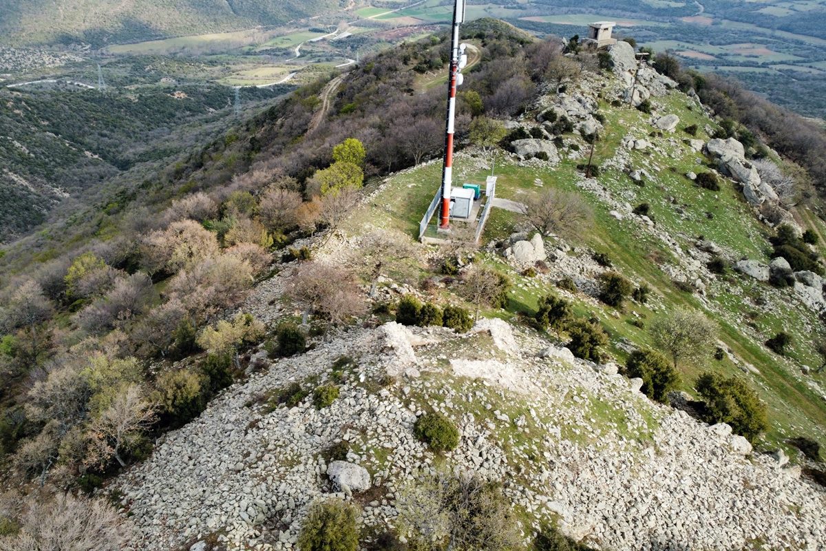
5 / 13

6 / 13

7 / 13

remains of dry-stone wall
8 / 13

ruins of a settlement in the interior of the ancient fortification
9 / 13

ruins at the SE side of the hill
10 / 13

foundations of a building
11 / 13

ancient sola disc carved on the rock
12 / 13

a strange rock formation
13 / 13


THE END
| Location: |
| Atop the hill Asproula NE of the village Nikites of the Rhodope prefecture |
| Region > Prefecture: |  |
| East Macedonia & Thrace Rhodope | |
| Municipality > Town: | |
| City of Arriana • | |
| Altitude: | |
|
Elevation ≈ 474 m (Relative Height≈140 m) |
| Time of Construction | Origin | |
| Unknown | BYZANTINE |
|
| Castle Type | Condition | |
| Ruined Tower |
In Ruins
|
Ruins of a Byzantine tower on the top of a hill where there are also stone piles from an ancient Thracian fortification, northeast of the village of Nikites in the prefecture of Rhodope.
History
The top of the hill was inhabited and fortified by the ancient Thracians during the Early Iron Age (11th-8th centuries BC).
Many centuries later, the site was used again by the Byzantines who built a tower on the top.
The dating of the ancient ruins of the hill to the Early Iron Age is derived from abundant surface finds such as rock carvings, an engraved solar disk and pottery of that era with the characteristic pressed geometric decoration and grooves. All these are common elements in similar installations of the ancient Thracians of the Iron Age on the heights of the Rhodope mountain range in Greece and Bulgaria. Two other similar cases in the prefecture of Rhodope are the “Acropolis of Agios Georgios” near Maroneia and the “Acropolis of Kremastos” near Ergani.
As for the Byzantine tower, there is no data on its dating. Logically, it must have been built sometime during the Middle Byzantine Period (6th to 12th century), but it is unknown exactly when.
The Byzantines built the tower taking advantage of the strategic location and the abundant building material from the ancient fortification.
Shells and roof tiles belonging to the Byzantine era were found at the site. It is possible that the tower was a guard post that informed the large castles of the wider area (Maroneia, Gratini, Koumoutzina) about enemy invasions from the north towards the plain of Komotini. The neighboring castle of Nea Santa, with which there is visual contact, seems to have had the same role, but we do not know if they coexisted in the same period of time.
Structure, Fortification & Buildings
On the northwest side of the elevation, where it is also the highest point, there is a Byzantine rectangular tower built from stones of different sizes with connecting mortar between them and the use of fragments of tiles in the gaps.
Its dimensions are 8.5✖7.5 meters (internal dimensions: 4.0✖5.0m), wall thickness 1.6-1.70m and a maximum surviving height of 2.30m.
Judging from the dimensions of the base, its original height must have been large and perhaps exceeded 10 meters.
The other ruins on the hill show that this was a settlement with a dry-stone enclosure built along the long narrow top of the hill of Asproula. From all sides the hill has quite steep slopes, which would make it very difficult for the enemy to approach. The fortification follows the relief of the peak from southeast to northwest, where the highest point (474m) with the Byzantine tower. In the middle there is a small neck, where a tall modern antenna is placed. At the south-east end is a concrete watchtower.
The perimeter of the fortification (whose outline is not clear at all points) is estimated to be 400-500 meters. This enclosure was a dry stone wall (without connecting material). Today it lies in stone pile.
The traces of the wall of the northern slope are visible throughout their course. On the southern side, however, the traces are preserved fragmentarily, making its course indiscernible. Probably part of it was destroyed by the contruction of a road to the top, for the placement of the antenna.
Next to the tower is a dense ruin area, full of stone piles from the ruins of buildings that have completely collapsed. It seems that around the tower and this ruins there was a separate inner enclosure like an inner citadel.
In the entire area inside and outside the ancient enclosure, mysterious carvings were observed in many places on the rocks. This is common in archaeological sites in Northern Greece and Bulgaria that are related to the ancient Thracians.
The most interesting find is a few meters outside the north side wall. It is a disc carved into the rock (photo 11). These disks are known as solar disks and are associated with the worship of the Sun. Other such discs have been found in the area of Thrace.
| First entry in Kastrologos: | May 2023 |
Sources
- Info, research and photos by Sakis Amfitreidis and his blog ΑΜΦΙΤΡΕΙΔΗΣ (April 2023)
- Δ. Τριαντάφυλλος, Μ. Κουτσουμανής, «Νέα επιφανειακή έρευνα σε γνωστές αρχαιολογικές θέσεις της Ροδόπης», ΤΟ ΑΡΧΑΙΟΛΟΓΙΚΟ ΕΡΓΟ ΣΤΗ ΜΑΚΕΔΟΝΙΑ ΚΑΙ ΤΗ ΘΡΑΚΗ 33η ΕΠΙΣΤΗΜΟΝΙΚΗ ΣΥΝΑΝΤΗΣΗ, 5-6 ΜΑΡΤΙΟΥ 2020
- Δ. Τραντάφυλλος, Αρχαιολογικόν Δελτίον 33/Β2 (1978), σελ. 309
|
|
| Access |
|---|
| Approach to the monument: |
| Paved road from Nea Santa to Kehros leads after 4.5km under the hill. From there an uphill dirt road after 1.5km brings to the top. |
| Entrance: |
| Free access |
| Other castles around |
|---|
| Avantas Castle |
| Fortress of Gratini |
| Castle of Nea Santa in Rhodope |
| Castle of Potamos |


