

Nea Santa, Maroneia-Sapes, Rhodope,East Macedonia & Thrace
Castle of Nea Santa in Rhodope


| Location: |
| On a low hill 1km SW of the village Nea Santa in Rhodope, in Thrace. |
| Region > Prefecture: |  |
| East Macedonia & Thrace Rhodope | |
| Municipality > Town: | |
| City of Maroneia-Sapes • Nea Santa | |
| Altitude: | |
|
Elevation ≈ 130 m (Relative Height≈15 m) |
| Time of Construction | Origin | |
| Unknown | BYZANTINE |
|
| Castle Type | Condition | |
| Castle Ruins |
In Ruins
|
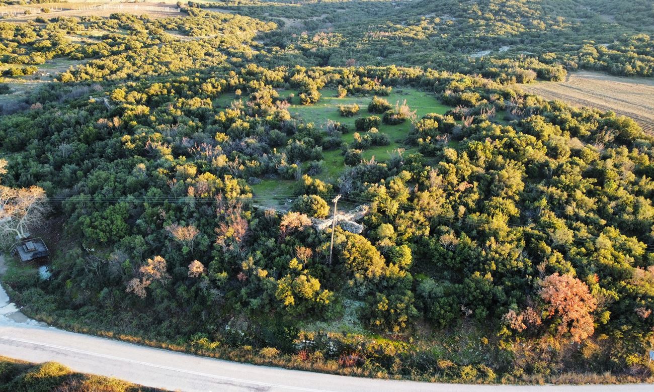
Ruins of an unidentified Byzantine castle southwest of the village of Nea Santa in the Prefecture of Rhodope, on a low hill with the name “Kales”.
The place is next to the road leading to the village.
It was a fortress and (apparently) a small settlement on the pass from the Thracian mountainous hinterland to the plain of Komotini.
History
The castle has not been identified with any fortification from the historical sources. So we don't know anything about its history. From the masonry it is obvious that it is medieval, i.e. Byzantine without a more specific dating being possible.
As far as we know, no systematic archaeological research has ever been done in the site.
According to Tremopoulos (1966), the castle of Nea Santa is a fortress of the same type as that of Nymphaea which guarded a passage/crossing and was a refuge for the local population in case of raids.
Structure, Fortification & Buildings
The fortification of the castle consists of a wall with a polygonal shape, with a perimeter of around 350 m, which had circular and rectangular towers at the corners. The fortification is in a dilapidated state.
Inside (photo 8), the ground is relatively flat. Scattered stones and ceramics can be found on the surface. It is reasonable to assume that due to the relatively large area, there was a settlement within the walls. However, there are no remains of buildings inside.
The wall thickness ranges from 1.5 to 1.8 meters.
Its masonry consists of stones of different sizes with binding mortar between them and a few ceramics.
The best preserved parts of the wall are on the north side. In the north-east corner there are remains of a circular tower and a wall reaching a height of almost 3 meters (2.80-2.90 meters). This is the most characteristic point of the castle (photos 2, 3).
In the north-west corner there is a wall approximately 2 meters high, while a 4 meter long wall protrudes vertically, which together with a smaller projection give the impression of being the remains of a rectangular tower (photo 6).
The rest of the castle wall is preserved at a small height or has been covered by vegetation, but the trace of its course is evident. Also visible are the ruins of two other towers at a low height. Probably the castle had other towers that are not preserved today.
Two hundred meters north of the castle there is the bed of the stream of Nea Santa (or “Kako Rema”) which is a tributary of Lissos (or Filiuris).
| First entry in Kastrologos: | January 2023 |
Sources
- Info and photos by Sakis Amfitreidis and his blog ΑΜΦΙΤΡΕΙΔΗΣ (January 2023)
- Website ΘΡΑΚΙΚΟΣ ΗΛΕΚΤΡΟΝΙΚΟΣ ΘΗΣΑΥΡΟΣ - Νέα Σάντα
- Τρεμόπουλος Κωνσταντίνος , «Η Κομοτηνή και οι αρχαιότητες της περιοχής της», Μορφωτικός Όμιλος Κομοτηνής, Κομοτηνή 1966, σελ.141
- Καρακούσης Δημήτρης, «ΡΟΔΟΠΗ-Τουριστικός Ιστορικός Αρχαιολογικός Οδηγός», 2002, σελ.141
|
|
| Access |
|---|
| Approach to the monument: |
| Coming from Arriana, one km before Nea Santa, there is a sign on the right for the village of Agiohori, on the right. Just around the corner, there is α chapel. This is where we leave the vehicle on foot. On the hill above is the castle of N.Santa. |
| Entrance: |
| Free access. |
| Other castles around |
|---|
| Tower of Asproula |
| Avantas Castle |
| Acropolis of Petrota |
| Castle of Potamos |


