

Amaxades, Iasmos, Rhodope,East Macedonia & Thrace
Wall of Anastasioupolis
1
2 / 25

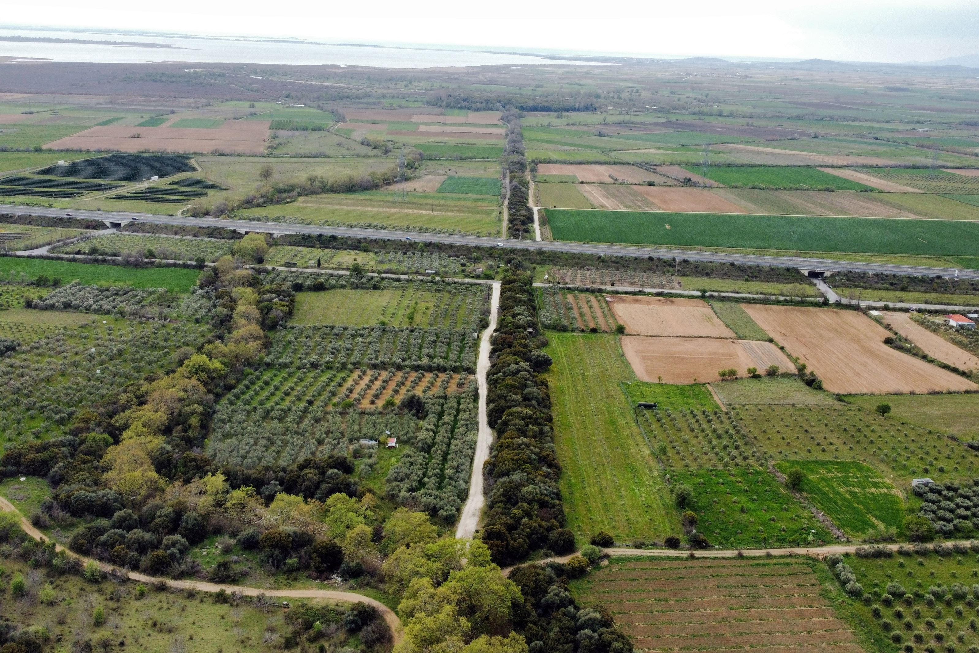
aerial view of the double wall of the south part
3 / 25

the old NR Xanthi Komotini at the junction with the wall
4 / 25

5 / 25

from the works for the crossing of the TAR pipeline
6 / 25

the northern end of the wall where it meets the mountain
7 / 25

remain of the wall of the part1 (h:3.5m, w:2m)
8 / 25

remain of the wall of the part1 (h:3m, w:1.7m)
9 / 25

remain of the wall of the part1 (h:3m)
10 / 25

remain of the wall of the part1
11 / 25
remain of the wall of the part2
12 / 25

τhe interior space between the external walls in part2
13 / 25

τhe square tower at part 2
14 / 25

four rows of plinths at the NW side of the tower
15 / 25

small opening at the west side of the tower, possibly for draining waters
16 / 25

wall of part 3, east side, max-height 3.2m
17 / 25

wall of part 3
18 / 25

west side of the double wall in part 3
19 / 25

est side of the double wall in part 3
20 / 25

wall in part4
21 / 25

wall in part 4
22 / 25

the remains of a round tower at part 4
23 / 25

guard post of the 20th century
24 / 25

guard post of the 20th century
25 / 25

the wall from thw south and the castle of Peritheoprion in the front

THE END
| Location: |
| In the plain between the villages Amaxades and Koptero in Rhodope prefecture |
| Region > Prefecture: |  |
| East Macedonia & Thrace Rhodope | |
| Municipality > Town: | |
| City of Iasmos • Amaxades | |
| Altitude: | |
| Zero Altitude |
| Time of Construction | Origin | |
| 6th cent. | BYZANTINE |
|
| Castle Type | Condition | |
| Cross-Wall |
Not Good
|
A long Byzantine wall that crosses the plain between the villages of Koptero and Amaxades in the prefecture of Rhodope. It starts from the castle city of Anastassioupolis–Peritheorion, in the South, and reaches the foot of the mountains of the Rhodope range in the North.
Location & Strategic Scope
The length of the wall is 2300 meters, blocking the narrowest lowland passage between Lake Vistonida and the Rhodope mountains. The old National Road of Xanthi Komotini crosses it vertically (photo 3), while the Egnatia Road passes over it. It is also crossed by the railway line.
More specifically, the wall starting from the northern walls of Anastasioupolis, reached the southwestern slopes of the hill named “High Aqueduct”, at a point where a small canyon is formed by the adjacent stream. This northern end of the wall is at an altitude of 70 meters. To the west of the wall, there is, along its entire length, the bed of a stream.
The wall was primarily an aqueduct. It carried and protected the pipeline that carried water from the hill to Peritheorion. Secondly, it was also a point of defense of Thrace against invasions from the west, although it is not known whether it was ever useful in any military operation.
The area has been inhabited for a long time and Anastasioupolis was in a strategic point because it was built on the north side of Lake Vistonida, right at the narrowest lowland pass between the Rhodope mountain range and the sea. The city, in addition to being a station on the Egnatia road, was also an important port as Vistonida was not then blocked off from the sea as it is today. In fact, the main gate of the city was the southern entrance from the port side. So the fortified Anastasioupolis together with the wall blocked the only land passage from the plain of Xanthi to the plain of Komotini and vice versa.
Today, however, the geomorphology of the area has changed since the alluvium of the Cosynthos River and other streams have lowered the bed of Lake Vistonida 2.5 kilometers south of the castle.
History
The wall was built during the reign of Justinian, in the 6th century. Obviously, its purpose was the safe water supply of Anastasioupolis.
In the 6th c. A.D. Anastasioupolis was described by the historian Procopius in his work Peri Ktismaton. The name "Anastasioupolis", according to Ioannis Kantakouzenos is due to the emperor Anastasios I (491-518), who fortified it for the first time.
The city was built on the site of a Roman station on via Egnatia with the name Stabulo Diomedis (=Stables of Diomedes, as around there it is believed that the horses of Diomedes from the related labor of Heracles grazed).
The bishopric of Anastasioupolis appears as a subject of the metropolis of Traianoupolis from post-Justinian times until the 9th century, when its new name “Peritheorion” appears for the first time.
Peritheorion emerged as a strategically important castle for the control of the region in which several historical events occurred and was one of the last urban centers of Thrace to succumb to the Ottomans, after experiencing a period of self-government. Few Christian inhabitants lived inside the castle at least until the end of the 17th century. Later it was abandoned and deserted.
Back to Procopius, who mentions that Anastasiopolis used to have walls, but its coast was unprotected. During Justinian's reign, the coastal fortifications and the aqueduct that supplied the city with water were built.That's how we know for sure that the wall was built in the first half of the 6th century.
During the 17th century, the traveler Evliia Celebi refers to the fortress of Anastasioupolis, calling it “Bourou fortress”. He mentions that inside the fortress, at that time, there were 50 Christian houses and that it was located on the shores of the lake. It had two gates: one to the south towards the beach and the other to the west, where it faces the river Karasos (Kosynthos). As a continuation of the fortress, a single wall extends to the north. From there to the mountains, its length is about an hour. Nothing can pass along the wall, neither man nor caravan. The only passage was the coastal gate, from which tolls and customs fees were collected (From this information it appears that the crossing was continuous without gates and the road inevitably led to the castle).
Stilpon Kyriakidis (1931) writes about the rafortification: “it is a strange double wall that starts from the north-west edge of the castle, goes straight to the north and reaches the foot of the mountain and separates it into east and west with an empty space between them”.
He also points out, like Celebi, that he did not find any door along the entire course of the wall, concluding that whoever wanted to pass from one side to the other, was forced to pass under the towers of Burou Kale.
Undoubtedly, the wall that was built under Justinian would receive additions and repairs in the following centuries. And it is surprising that after so many invasions and destructions, its ruins still exist and are even preserved in a relatively better condition than other castles.
Structure, Fortification & Buildings
As mentioned above, the length of the wall was about 2300 meters. The wall survives for almost its entire original length, with the exception of a few meters lost on the north side, where the fortification meets the stream (apparently, there, the wall was taken by the river).
Large part it is covered by vegetation as a result of which it is not easily visible (photo 1) even though it is a large construction (with the exception, of course, of the points of intersection with the road arteries). What an uninformed passer-by sees is a tree-lined transverse line across the plain perpendicular to the modern Egnatia Road.
The wall for the most part was double. That is, there was the eastern and the western wall and in between there was an empty space (photos 2, 5, 12). On average the thickness of the wall was 1.5 meters and the gap between them was 4 meters. This intervening gap was a safe inner corridor for the defenders, but also for the laying of pipes to carry the water to the city. (Let’s point out here that no signs of ancient pipework have been found on the spot yet.)

Dimensions of the double wall
The masonry of the partition consists of mudstone construction with strong lime mortar between the stones but also the use of bricks. The plinths are most often placed irregularly inside the wall. Only in one of the towers (which may be later than the rest of the construction) are plinths in a quadruple row visible (photo 14).
At intervals there were towers from both sides (east and west). Of these three were identified, but undoubtedly there would have been more.
No trace of a gate was found at any point. Probably there were no gates and as Celebi also mentioned, anyone who wanted to pass peacefully from this point had to pass in front of the castle of Peritheorion, under whose control the passage was.
The thickness of the wall ranges from 1.30 to 2 meters and the maximum height measured reaches 3.5 meters. The course of the wall is today interrupted in several places, such as by Egnatia Street, the Old National Highway, the railway line, but also by dirt roads, since it is in the middle of cultivated lands.
Since the wall is quite long (2.3 km), we will describe it by sections starting from the foot of the mountain up to the castle according to the drawing below:

the parts of the wall
The wall in section 1 (photos 6–10), which is the northern end of the wall, starts from the southwest foothills of the so-called Aqueduct hill at an altitude of 70 meters and reaches almost the stream (10 meters before it). It is a single wall 150 meters long along the slope, parallel and east of the stream.
Section 2 The wall in section 2 (photos 11, 12) starts west of the watercourse and reaches Egnatia Odos (length 450 meters). From the beginning of this section begins the double wall, which is covered by dense vegetation. The maximum height reaches up to 3-3.5 meters. The eastern wall and the western wall are 1.5 meters thick and there is a gap of 4 meters between them. Therefore, the total thickness of this double wall reaches approximately 7 meters.
Between the Old National Road and Egnatia, from the western side, there are the remains of a rectangular tower with dimensions of 7✖6 meters and a surviving height that does not exceed 1.5 meters (photos 13, 14).
The wall in section 3 (photos 16–19) starts from Egnatia Street and reaches the railway tracks. It is 600 meters long and is double throughout its course.
Section 4The wall in section 4 (photos 20,21,22) starts from the railway line and reaches the northern walls of the Peritheorion castle. The length of the section is 1100 meters. This wall was probably double throughout its course. There are doubts about this for the last 400 meters (near the castle), where wall ruins can be seen only from the eastern side. The raging vegetation that prevails does not allow further on-site research to establish the existence of a western wall.
Near the railway tracks, a circular tower (photo 22) is preserved from the west side with a height of 3.5 m. Also, at a distance of 100 meters from the Peritheorion castle, the foundations of a rectangular tower can be seen at the eastern side with dimensions 4✖6.
Throughout the length of the wall, fortified structures belonging to the 20th century (guardposts, circular towers, concrete watchtowers) were found at intervals. For the building of these fortifications, it seems that construction material from the wall was used together with cement (photos 23, 24).
| First entry in Kastrologos: | March 2024 |
Sources
- Research, presentation and photos by Sakis Amfitreidis and his blog ΑΜΦΙΤΡΕΙΔΗΣ (January 2024)
- Προκόπιος, Περί Κτισμάτων
- Σταυρούλα Δαδάκη, Ιστοσελίδα ΟΔΥΣΣΕΥΣ - Υπουργείου Πολιτισμού - Αναστασιούπολις - Περιθεώριον
- Κυριακίδης Στίλπων «Μπουρού Καλέ - Αναστασιούπολις - Περιθεώριον. Θρακικά Ταξείδια», Ημερολόγιον της Μεγάλης Ελλάδος , 1931, σελ. 195-220
- Website ΚΑΣΤΡΑ ΚΑΙ ΟΧΥΡΑ ΤΗΣ ΕΛΕΥΘΕΡΙΑΣ - Το βυζαντινό μεγαλείο της Αναστασιούπολης-Νικόλαος Θ. Κόκκας
|
|
| Access |
|---|
| Approach to the monument: |
| Approach from various points. To visit the section above Egnatia, we move through the Old Komotini-Xanthi National Road, from Koptero to Amaxades. At 2.5 km we meet the intersection of the wall with the road. |
| Entrance: |
| Free access. |
| Other castles around |
|---|
| Castle of Linos |
| Mesegouni Fortress |
| Tower of Molyvoti |
| Castle of Peritheorio |
| Castle of Polyantho |
| Polystylon |
| Castle of Poroi |
| Xanthi Castle |


