

Polyantho, Iasmos, Rhodope,East Macedonia & Thrace
Castle of Polyantho
1
2 / 21

3 / 21

4 / 21

part of the east wall
5 / 21

part of the east wall
6 / 21

part of the west wall
7 / 21

part of the west wall
8 / 21

part of the south wall
9 / 21

the second tower at the eastern wall
10 / 21

the gate
11 / 21

the gate from above
12 / 21

the keep at the top
13 / 21

the keep
14 / 21

the keep
15 / 21

the interior of the keep
16 / 21

detail of the interior with thw Byzantite layer of bricks
17 / 21

an arrow-opening in the keep
18 / 21

the entrance to the area of the keep
19 / 21

the “thick wall” toward the top (3m high)
20 / 21

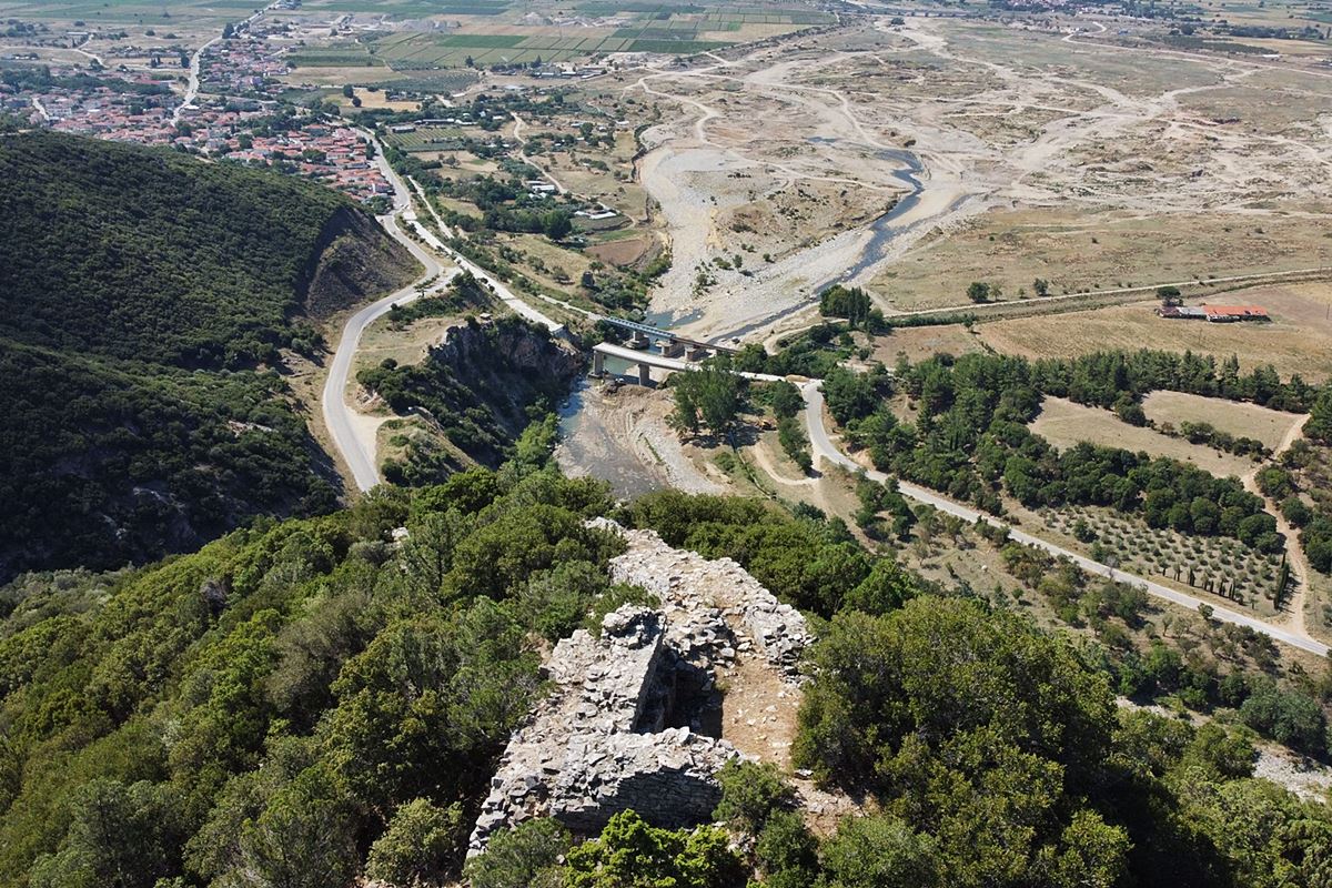
the stone bridge of the 17th-18th cent. Under the castle
21 / 21

the conical hill of the castle fron the road

THE END
| Location: |
| On a conical hill ao the east side of Kompsatos river in the Rhodope prefecture, 1km nort of the village Polyantho. |
| Region > Prefecture: |  |
| East Macedonia & Thrace Rhodope | |
| Municipality > Town: | |
| City of Iasmos • Polyantho | |
| Altitude: | |
|
Elevation ≈ 190 m (Relative Height≈140 m) |
| Time of Construction | Origin | |
| Unknown | BYZANTINE |
|
| Castle Type | Condition | |
| Castle |
Few Remains
|
A strong Byzantine fortress on a conical hill next to the river Kompsatos, north of the village of Polyanthos in Thrace, in the Rhodope prefecture.
Location & Strategic Scope
The castle is in a strategic location controlling the point where the Kompsatos river exits into the plain of Komotini. It is also located above the old Egnatia road, which at this point followed approximately the route of the modern Xanthi-Komotini provincial road. Below the castle, a stone arched bridge (photo 20) is preserved, which is a construction of the 17th or 18th century.
Due to the location and the height of the hill, the castle had a very wide field of view that covered a large part of the Thracian coast, from Maroneia to Polystylon (Avdira). And of course, it had visual contact with two of the most important cities of Byzantine Thrace: Mosynoupolis, at a distance of about 6 km to the east, and Anastasioupolis (Peritheorion), 15 km to the southwest.
The castle had strong natural protection as the hill is surrounded, apart from Kompsatos in the west, by a stream in the east as well, while the hill itself has very steep slopes, with big rocks.
History
The castle is considered to be Byzantine, but no further information is available. It has not been identified with a castle from historical sources and we do not know its medieval name or its history. Its construction features and the finds inside are not particularly helpful in a precise dating.
Since this is an important castle, it should be mentioned by some sources. The only indication we have is from the book “Historiai” by Ioannis Kantakouzenos, where there is information that in 1344, during the second Byzantine civil war of the 14th century, Mattheos Kantakouzenos occupied Koumoutzina (Komotini) on behalf of his father Ioannis. and the nearby fortresses of Kranovunion, Paradimo, Asoma and Stylarion were surrendered to him. We do not know if the castle of Polyanthos – which is 11 kilometers from Komotini – is one of them.
If it does not belong to this group of castles, then it is certainly one of the castles destroyed in 1206 by the Bulgarian tsar Ivan I (also known as Kaloyan or Ioannitzes or Skylogiannis), at the time when he razed the neighboring Mosinopolis and many other Thracian cities.
However, these are all assumptions as we do not know anything specific about the history of the castle.
Structure, Fortification & Buildings
The castle of Polyantho is protected by a fortified enclosure that starts from the bottom and extends almost to the top of the hill. It is impressive that there is an elevation difference of about 110 meters from the lowest point of the fortification to the donjon.
The total length of the wall is about 550 meters. The wall consists of large stones and the gaps in between are filled with smaller stones with white binding mortar between them.
The western and eastern wall and generally the higher northern part of the castle is preserved in better condition, while in the southern and lower part most of the wall has collapsed or has been covered by vegetation.
The wall has a thickness ranging from 1.20 to 1.60 meters and a height reaching up to 2 meters. In some parts of the western wall there are vertical high rocks that are integrated into the fortification by replacing the wall.
In the upper part, the fortification shows a peculiarity. At one point the enclosure closes and the curtain wall continues towards the top of the castle in a single, thick line for about 50 meters until it ends at the strong keep (see layout). This part of the wall is thicker than the rest of the wall and ranges from 2.50-2.70 meters, with a height that reaches up to 3 meters. This wall (photos 2,3,12) seems to have functioned as a safe corridor to the main tower.
This “thick wall” ends in a strong square tower (the keep of the castle) that is currently half-demolished (photos 1,12,13). It should be noted that the keep is the highest point of the castle, but not at the top of the hill. Its dimensions are 6✖6 meters. The entrance to it was through the south side of the thick wall, from a demolished entrance 80 cm wide (photo 18).
The maximum internal height of the tower today reaches 2.5 meters, specifically on the eastern side, in which a niche that was probably an arrow-loop is preserved (photo 17). The construction of the tower includes a Byzantine feature: zones of bricks in four horizontal rows (photo 16). Another similar insertion seems to have started two meters higher where only the remains of the first horizontal row can be seen.
The tower is based on a unusual base with stepped reinforcements, something like diazoms, which in height reach up to 3 meters adding more volume and width to the tower (photo 14).
The are no other structures in the Byzantine castle higher than the keep. There is only a narrow, rocky, steep and rugged ridge that continues higher.
On the low south side of the castle, where the wall is preserved at a low height, there is a rather elaborate structure about 3 meters high, with two vertical projections. Here was probably the main gate of the castle, which seems to have been sealed at some later time (photos 10,11).
At the top of the eastern wall are the remains of a small trapezoidal tower with dimensions of 2.40✖2.40 m. (photo 9) The fortification had probably more towers like this, which today have either been collapsed or are covered by dense vegetation.
Building foundations, stone piles and scattered ceramics can be seen both inside and outside the castle, which appear to be the remains of a medieval settlement.
Finally, we must mention that 350 meters north of the keep of the Byzantine castle of Polyantho, further on the same rugged ridge, there are the ruins of an ancient Hellenistic fortress, which is indicative of the point's timeless strategic importance.
Also, 200 meters southeast of the castle, and next to the road, are the ruins of a three-aisled basilica dating back to the Early Christian to Middle Byzantine periods.
| First entry in Kastrologos: | August 2022 |
Sources
- Research, photos, video and info by Sakis Amfiteides and his blog ΑΜΦΙΤΡΕΙΔΗΣ (2022)
- Website ΘΡΑΚΙΚΟΣ ΗΛΕΚΤΡΟΝΙΚΟΣ ΘΗΣΑΥΡΟΣ - Πολύανθον (βυζαντινή εποχή)
|
|
| Access |
|---|
| Approach to the monument: |
| Park at the foot of the hill, at the plateau of the road from Iasmos, and walk to the top from the east side of the hill, initially through a dry stream. We reach the castle after a difficult hike through thick vegetation and rough terrain. |
| Entrance: |
| Free acces |
| Other castles around |
|---|
| Wall of Anastasioupolis |
| Komotini Walls |
| Castle of Linos |
| Tower of Molyvoti |
| Mosynopolis |
| Fortress of Nymfea |
| Castle of Peritheorio |
| Castle of Poroi |
| Castle of Thamna |


