

Skortsino, Megalopoli, Arcadia,Peloponnese
Castle of Chelmos


| Location: |
| Agios Konstantinos hill, 4 km from village Skortsino of Arcadia in Peloponnese |
| Region > Prefecture: |  |
| Peloponnese Arcadia | |
| Municipality > Town: | |
| City of Megalopoli • Skortsino | |
| Altitude: | |
|
Elevation ≈ 760 m (Relative Height≈180 m) |
| Time of Construction | Origin | |
| late 13th century | Late-BYZANTINE |
|
| Castle Type | Condition | |
| Castle |
Rather Poor
|
A medieval castle which was built in the interior of a large ancient fortress in the late 13th century either by the Franks or by the Byzantines of the Despotate of Mystras.
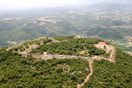
The castle is built on the hill of Agios Konstantino, 4km from the village Skortsino of Arcadia. This is a location of stategic importance because mountains Taygetos and Parnon converge here, forming the upper part of the valley of Evrotas. It was the northernmost part of the dominion of Ancient Sparta and the passage to Arcadia to the north. On the hill, there are findings from the classical period as well as from the Mycenaean era and, of course, from the Middle ages.
The castle was in direct optical contact with the castle of Loganikos and other forts in the region.
History
Initially, it was an ancient castle, named Athinaion, built in 229 BC by the Spartans who destroyed it in 218 BC in order not to be taken by the Macedonians.
After that, the hill served as a stronghold again in the late 13th century when the Francs or the Byzantines built a small castle within the walls of the ancient fortress.
It is certain that the Byzantines had it in 1296 because it is known that from this castle left a small unit under Leon Mavropapas to seize the castle of Agios Georgios in Scorta.
The last document referring to this castle was a Chrysovoulon of Emperor Andronicos II Palaeologos in 1320 according to which the castle became property of officers of the Despotate of Mystras.
After 1320, it must have lost its value because it was not, any longer, at the frontiers with the Principality of Achaea, following the advancement of the Greeks to the north who occupied castles such as Leontari, Acova and Karytaina.
Helmos is mentioned twice in the Chronicle of Morea as “the place of Helmos” which might refer to the mountain and not the castle. It was not in any list of fiefs and is not mentioned in the history of the Ottoman conquest (1460).
Most probably it was abandoned sometime in the 14th century.
Structure, Fortification & Buildings
The outer wall of the ancient fort has a perimeter of 1955 m. enclosing an area of 19.1 hectares. The central fort on the south side of the hill has a perimeter 896,70m. and encompasses an area of 39.5 acres.
In the southern part of the plateau, which has the highest altitude, between the east and west side of the outer wall was built a wall separating the medieval castle that has a perimeter 345m. and an area 4181 sqm. (4 acres), (i.e. 1/10 of the ancient area) reinforced by six towers.
| First entry in Kastrologos: | July 2014 |
Sources
- Website ExploringGreece - Chelmos Castle
- Article: Leonidas Souchleris, in the website Loganikos.gr - Ο Λόφος του Χελμού
- W. Loring (1895). Some Ancient Routes in the Peloponnese. The Journal of Hellenic Studies, 15, pp 25-89
- Antoine Bon, 1969, La Morée franque. Recherches historiques, topographiques et archéologiques sur la principauté d'Achaïe (1205-1430), Ed. de Boccard, pp.518,663
- ΑΡΧΑΙΟΛΟΓΙΚΟΝ ΔΕΛΤΙΟΝ, issue 63/Β1, 2008, p.382
|
|
| Access |
|---|
| Approach to the monument: |
| The village Skortsinos is 17km from Megalopoli on the road to Sparta. From Skortsinos a dirts road 4km leads to the castle; the last part neede uphill walking |
| Entrance: |
| Free entrance |


