

Kouteli, Kalavryta, Achaea,West Greece
Kakavos castle
or Cocovax settlement or Castle of Skylolakka
1
2 / 10

NE fortification-Sakis Lemonakis, Nov 2019
3 / 10

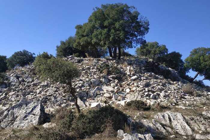
ruins of the keep-Sakis Lemonakis, Nov 2019
4 / 10

SW tower-Sakis Lemonakis, Nov 2019
5 / 10

north wall-Sakis Lemonakis, Nov 2019
6 / 10

north wall-Sakis Lemonakis, Nov 2019
7 / 10

Sakis Lemonakis, Nov 2019
8 / 10

Sakis Lemonakis, Nov 2019
9 / 10

Sakis Lemonakis, Nov 2019
10 / 10

Sakis Lemonakis, Nov 2019

THE END
| Location: |
| At the abandoned settlement of Kakavos, 3km north of Kouteli in Achaea |
| Region > Prefecture: |  |
| West Greece Achaea | |
| Municipality > Town: | |
| City of Kalavryta • Kouteli | |
| Altitude: | |
|
Elevation ≈ 985 m (Relative Height≈200 m) |
| Time of Construction | Origin | |
| perhaps 13th cent. | FRANKISH |
|
| Castle Type | Condition | |
| Castle Ruins |
In Ruins
|
Ruins of a fortified settlement, unknown and unidentified, on a hill north of the village Kouteli in Achaea in the vicinity of Kalavryta. At the foot of the hill, survives the toponym Kakavos (an important detail for the identification of the place).
History
The settlement has not been properly researched, and we cannot have an accurate chronology. However it is obvious that this was a medieval settlement.
We believe that most probably here was the fief of Kakavos, one of the 24 fiefs of the Frankish barony of Acova.
Kakavos, that is recorded as Cocovax in the Italian and French versions of the Chronicle of the Morea, was one of the 8 fiefs that were returned to Margarita of Passsavas by the Prince of Achaea William II de Villardhuin in 1276, in an episode that had created a turmoil in the Principality those days.
The hypothesis that this place is identified with Cocovax requires more research to be verified, but based on the toponym, the proximity with Acova, the proximity with Goumenissa (another of the 8 fiefs), and the fact that actually there is a medieval settlement at this location, we believe that chances are good for Kakavos to be the historic Cocovax.
Structure, Fortification & Buildings
The settlement includes an internal fort at the highest point enclosed in a perimeter of 130m of collapsed walls. The construction is without mortar.
At the NE corner, there are ruins of what must have been the keep, measuring 4✖4 m.
Lower, at the opposite SW corner there are traces of another tower. The settlement spreads on a slope SW of the keep with many ruined houses within a perimeter of 270m.
| First entry in Kastrologos: | December 2019 |
Sources
- Photographs, spotting and info by Sakis Lemonakis and his blog ΑΜΦΙΤΡΕΙΔΗΣ
- Antoine Bon, 1969, La Morée franque. Recherches historiques, topographiques et archéologiques sur la principauté d'Achaïe (1205-1430), Editions de Boccard, pp.147, 394,396
|
|
| Access |
|---|
| Approach to the monument: |
| From the upcountry road Aigio Kalavryta take the dirt road 1km north of Kouteli at Kouvelos point. From there the hill of the castle is visible. A 1-2km difficult dirt road leads near the top. |
| Entrance: |
| Free access |


