

Ano Salmenico, Aigialeia, Achaea,West Greece
Castle of Salmenico
or Castle of Orgia or of Oria
1
2 / 10

Signs of the land-sliding of thecastle hill
3 / 10

4 / 10

traces of towers from SE (Moreas Project)
5 / 10

the point where there are visible remains of the castle
6 / 10

drawing by Sphekopoulos (1968)
7 / 10

the location of the settlement outside the castle
8 / 10

the southeast side
9 / 10

the southeast side
10 / 10

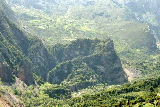
view of the hill from the south

THE END
| Location: |
| On a hill south of Ano Salmenico, Achaea, NW Peloponnese |
| Region > Prefecture: |  |
| West Greece Achaea | |
| Municipality > Town: | |
| City of Aigialeia • Ano Salmenico | |
| Altitude: | |
|
Elevation ≈ 590 m (Relative Height≈120 m) |
| Time of Construction | Origin | |
| 14th cent. | FRANKISH |
|
| Castle Type | Condition | |
| Castle Ruins |
Few Remains
|
The Castle of Salmenico or Castle of Oria is located in Achaea, in the mountainous area east of Panachaikon mountain. Today almost nothing remains of the castle.
The castle was built by the Franks of the Principality of Achaea and a small city grew next to it.
The castle is also called “Castle of Oria” (as several other castles in Greece) after a beautiful daughter who supposedly fell from the castle and was killed after the surrendering of the castle to the Turks.
Location & Strategic Scope
It is located on one of the peaks northwest of Mount Tsetsevo. To the east of the castle rises the imposing volume of another mountain called Sendoukia.
The site is above two streams that a little further north of the castle join to form the Phoinikas river. This river until the beginning of the 20th century was named Salmenicos.
The hill can only be accessed from the east, up to a point beyond which access today is almost impossible.
Salmeniko consisted of the castle and a settlement outside the castle (the burgo) whose ruins can be found at a point about 800 meters southwest of the castle where the settlement of Mesochori or Misochori is located (which today has 2-3 uninhabited houses).
The hill of the castle has undergone geological changes to a great extent which have altered its morphology and practically made the castle disappear. The entire western side of the hill seems to have collapsed, while the eastern side has also suffered subsidence. It is obvious that in its original form the castle occupied a much larger area and the settlement reached its foot.
History
Reference to the existence of the castle is made for the first time by the Byzantine historians Georgios Sfrantzis and Laonikos Chalkokondilis in their almost simultaneous accounts of the campaign of sultan Mohammed II in the Peloponnese in 1460.
In Hopf's maps of Frankish castles, Salmenico is listed in 1471 as belonging to Venice.
The name reappears on Alberghetti's map of 1545. In the censuses of the Second Venetian Empire, in 1689 and 1700, Salmenico is registered as having 160 and 161 inhabitants respectively, but in this period, the entry probably refers to the younger settlement in Kato Salmeniko and not the medieval settlement and the castle.
The castle must have been built towards the end of the 14th century by the Frankish rulers of Patras. There is no mention of Shalmenico in older sources (it is not mentioned, e.g. in the Chronicle of Moreas).
The castle of Shalmenico went down in history for the fact that it made it very difficult for the Turks and bravely resisted Sultan Muhammad II the Conqueror himself. It was the last castle captured by the Ottomans in the Peloponnese, long after the fall of great castles such as Mystras, Santameri and Chelmoutsi.
This is whar happened:
In 1460 Mohammed the Conqueror invaded (for the second time) the Peloponnese. Then the Despotate of the Morea was finally overthrown and the Byzantine castles surrendered one after another, most without a fight.
Salmenico was the last that had not surrendered, Muhammad sent a messenger and demanded the surrender of the city and the castle. The inhabitants refused knowing that most of them would be enslaved or slaughtered as happened in the other castles that the Turks had taken.
The commander in the city was Graitzas Konstantinos Palaiologos (no relation to the imperial dynasty), while many refugees from other regions had also taken refuge there. Defenders and civilians were over 6,000, Greeks and Arvanites.
Graitzas had made good preparations and had sufficient supplies of food and arms. His refusal to surrender was truly an act of heroism, if we consider that the Turks at that time had swept everything and sown havoc by slaughter and burning without anyone being able to resist them, not only in the Peloponnese but throughout the Balkans.
After Graitzas' negative response Muhammad began the siege targeting initially the fortified settlement outside the castle. The Turks were positioned on the surrounding hills and were firing cannons. But the city endured. After seven days the Turks were able to cut off the sources of water. After this, the besieged from the castle threw ropes with cotton tied to the end and thus took water from the river, but the Janissaries realized this and cut them. Eventually, without water, the lower castle surrendered. Of the 6,000 who surrendered, the sultan selected 900 boys and sent them to become janissaries while the rest were distributed to the army to become slaves.
But the defenders of the citadel on the hill still held out. Muhammad then announced to Graitzas that he would let him go with his men undisturbed and with honor. Graitzas agreed and the Sultan withdrew with most of his army to Vostitsa (Aegio), leaving behind the Albanian Hamouza Zenevisi pasha, commander of Thessaly and the Peloponnese.
However, Hamouzas did not keep the agreement and arrested the first of the Byzantine guard who were dispatched out of the castle to test the real intentions of the enemy. After this, Graitzas shut himself up in the castle and sent word to the Sultan that he had breached the agreement.
Muhammad was enraged, dismissed Hamuzas and replaced him with Zaganos pasha.
Zaganos besieged the castle for a year, from August 1460 until August of the following year. During this period, the Turks had as their base the neighboring castle of Listrena (it should be noted that Zaganos was also ordered to campaign in the northern Balkans during this period). Eventually Graitzas came to an agreement with Zaganos and the garrison left the castle with their armaments. The Turks allowed them to take refuge in Nafpaktos, which was then a possession of Venice.
Graitzas soon after became a general of the Venetians and is mentioned in historical documents as Graziano Paleologus and commander of the Venetian light cavalry.
In 1467 (when the First Venetian-Turkish war had already begun) it is reported that there was a garrison of 30 Turks in the castle. Shortly after, it was occupied, temporarily and under unspecified conditions, by the Venetians, who were operating at that time in the area of Patras.
Perhaps during their departure the Venetians destroyed the castle so that it would not be used by the Turks. This may have happened either in the 1470s or at the end of the Second Venetian rule around 1715. In other words, it is possible that the extensive destruction of the castle was due to explosion and not landslide.
Structure, Fortification & Buildings
Because of the cliffs surrounding the hill, the castle must not have had fortification on all sides. But that's something we don't know for sure.
Few traces of the castle remain today, which cannot provide a sufficient picture of the layout of the fortification. Landslides on the hill have obliterated most of the hill and the castle. Due to the fragility of the soil, the eastern side of the hill has suffered subsidence long ago, while part of the western side has also collapsed. These disasters have left intact only a small part at the top of the crescent-shaped hill. At the edge of the south-southeast side of this crescent can be seen some remains of the castle.
Salmenico was one of the sites investigated in the 1990s by the Morea Project or MARWP (Minnesota Archaeological Researches in the Western Peloponnese) led by Professor Frederic Cooper of the University of Minnesota, USA.
The findings of this program are summarized as follows for Salmenico:
Perimeter wall, thick. 2 m., with towers to the N. and S., runs along the rim of the summit of the mountain. A rectangular building, 5.90✖4.90m, located inside the wall. On the eastern slopes a series of rectangular foundations of Frankish houses similar to those found in the castle of Ochia and Stavraki. (AD 52/B1-1997).
Also from the Moreas Project: The ruins of 3 towers can be seen on the south side of the hill (photo 4). Further down on the steep southern slopes are rubble from collapsed houses and fortifications. (Kourelis, 2003).
However, the image of the castle has changed since the time of the Moreas Project, as the landslide phenomenon continues.
Especially for the settlement at Misochori (800m SW from the castle), we must mention that apart from the ruins of 10 houses found by the Moreas Project, part of the fortified enclosure is also preserved at a low height. The fact that the settlement had its own fortification is also evident from the story of the siege of Salmenico in 1460.
Misochori and its few ruins are easily accessible (although we don't have a photo) but the climb to the castle is, as has been said, almost impossible.
Regarding the difficulties of accessing the castle, Sebastian Shroeder's comment below is very helpful.
Since we live just a little bit down the valley we always wanted to explore this castle if possible. There is a gravel road parallel to the Phoenix river which will almost lead you to the mountain where the castle is supposed to be. I did some research on google earth and thought that it might be possible to enter the castle along the stream that runs east of the mountain. There are two streams surrounding the mountain. One on the west flank which can be seen from the road and one on the east which runs through the site. Both streams meet north of the castle and form the Phoenix River.
From the outside absolutely no remains of walls, houses etc. can be seen. When we approached the castle by feet from South it actually becomes clear that we would not be able to reach the East Stream as it runs down in a gorge 40-50 below the altitude we actually were and that the terrain is much to steep in order to reach the river safely. From the point we were however the remains of a path could be seen which must have been built in recent years (concrete). Parts of this path were already taken down by landslides. We climbed to the path and just after some meters the path ended. The purpose of this path is unclear.
We continued to walk/climb on the South Flank but its very heavy terrain with landslides formed out of rocks and areas of oak trees. When we reached the end of the South Flank, to the East the mountain leads almost vertical into the river gorge and in front of you there is the mountain crest consisting of 6-8m vertical rocks. I tried to climb up at one point in order to have a look over the crest into the castle valley but its impossible w/o climbing equipment. Therefore we returned.
As a conclusion I would say it is impossible to get into castle via any point of the outer flanks (South, West, North) as long as you are not something like a freeclimber or experienced mountaineer. The only possible way seems to be via the river. Next time we will try to walk the East Stream upwards in order to reach into the castle, but this has to wait until next summer when the stream carries less water.
On the stream, one kilometer south of the castle (position 38.225°N, 21.9226°E) an old stone bridge is preserved which, according to Sphikopoulos, is contemporary with the castle.
| First entry in Kastrologos: | November 2012 | Last update of info and text: | April 2023 | Last addition of photo/video: | April 2023 |
Sources
- Ιωάννης Θ. Σφηκόπουλος, «Τα Μεσαιωνικά κάστρα του Μορηά», Αθήνα,1968, σελ.138, 140-143
- Video by the user Kostas Gertzos ΚΑΣΤΡΟ ΣΑΛΜΕΝΙΚΟΥ ή ΩΡΙΑΣ ή ΟΡΓΙΑΣ, ΑΧΑΪΑ (DRONE). CASTLE of SALMENICO, ACHAIA, GREECE.
- Ουΐλλιαμ Μίλλερ, 1909, Ιστορία της Φραγκοκρατίας εν Ελλάδι (1204-1566), (William Miller, The Latins In The Levant: A History Of Frankish Greece, 1204-1566) μετάφρ. Σπυρ. Π. Λάμπρου, μετά προσθηκών και βελτιώσεων, Εν Αθήναις Ελληνική Εκδοτική Εταιρεία, 1909-1910, τόμοσ Β’, σελ.170-172
- F R E D E R IC K C O O P E R - J O S E P H A L C H E R M E S, Αρχαιολογικόν Δελτίον, τεύχος 52/Β1 (1997), σελ. 347,348
- Konstantinos Kourelis, “MONUMENTS OF RURAL ARCHAEOLOGY MEDIEVAL SETTLEMENTS ΙΝ ΤΗΕ NORTHWESTERN PELOPONNESE”, Presented to the Faculties of the University of Pennsylvania in Partial Fulfillment of the Requirements for the Degree of Doctor of Philosophy, 2003, pp.380-383
- Λαόνικος Χαλκοκονδύλης, Απόδειξις Ιστοριών Θ’
- Φώτης Κόντογλου, Ο ΚΑΣΤΡΟΛΟΓΟΣ, εκδόσεις ΑΡΜΟΣ, Αθήνα 2004 [Πρώτη δημοσίευση ΝΕΑ ΕΣΤΙΑ, 1947], σελ.139-145
- Γεώργιος Σφραντζής ή Φραντζής, Βραχύ Χρονικόν
|
|
| Access |
|---|
| Entrance: |
| The access to the castle is impossible. The castle is destroyed by landslides. Actually the whole mountain is falling apart. It is not only very difficult, it is extremely dangerous. |


