

Diodia, Messini, Messenia,Peloponnese
Castle of Diodia
or Castle of Lóï or Paliopyrgos of Sterna
1
2 / 29

east wall of tower
3 / 29

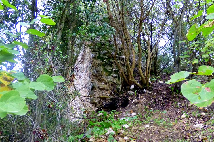
the tower
4 / 29

the tower from SE- photo by Y.Costopoulos, 2019
5 / 29

east wall of tower- photo by Y.Costopoulos, 2019
6 / 29

east wall of tower- photo by Y.Costopoulos, 2019
7 / 29

tower from south - photo by Y.Costopoulos, 2019
8 / 29

buried arched entrance - photo by Y.Costopoulos, 2019
9 / 29

access to the tower - photo by Y.Costopoulos, 2019
10 / 29

cistern exterior on access ramp - photo by Y.Costopoulos, 2019
11 / 29

cistern exterior on access ramp - photo by Y.Costopoulos, 2019
12 / 29

cistern opening - photo by Y.Costopoulos, 2019
13 / 29

cistern external wall - photo by Y.Costopoulos, 2019
14 / 29

tower wall - photo by Y.Costopoulos, 2019
15 / 29

cistern interior - photo by Y.Costopoulos, 2019
16 / 29

detail of east wall of the tower - photo by Y.Costopoulos, 2019
17 / 29

detail of east wall of the tower - photo by Y.Costopoulos, 2019
18 / 29

detail of east wall of the tower - photo by Y.Costopoulos, 2019
19 / 29

detail of east wall of the tower - photo by Y.Costopoulos, 2019
20 / 29

western wall remains - photo by Y.Costopoulos, 2019
21 / 29

western wall remains - photo by Y.Costopoulos, 2019
22 / 29

northern wall remains - photo by Y.Costopoulos, 2019
23 / 29

northern wall remains - photo by Y.Costopoulos, 2019
24 / 29

northern wall remains - photo by Y.Costopoulos, 2019
25 / 29

various remains in the area - photo by Y.Costopoulos, 2019
26 / 29

various remains in the area - photo by Y.Costopoulos, 2019
27 / 29

the fountain at the northern side - photo by Y.Costopoulos, 2019
28 / 29

the fountain at the northern side - photo by Y.Costopoulos, 2019
29 / 29

the hill of the castle from Southeast (Google Street)

THE END
| Location: |
| in an olive grove, about 1km north of the village Diodia of Messinia |
| Region > Prefecture: |  |
| Peloponnese Messenia | |
| Municipality > Town: | |
| City of Messini • Diodia | |
| Altitude: | |
|
Elevation ≈ 245 m (Relative Height≈50 m) |
| Time of Construction | Origin | |
| 13th to 15th cent. | FRANKISH |
|
| Castle Type | Condition | |
| Castle Ruins |
In Ruins
|
Few remains of a castle with a tower, at the top of a low and smooth hill with olive trees about 1 km NE of the village of Diodia, Messinia and 500 meters NW of the village of Sterna. Even closer is the village of Aetofolia, a few hundred meters north of the castle.
The area is called "Paliopyrgos", apparently because of the existence of this castle.
The old name of Diodia was Lóï (changed in 1927), hence the castle is mentioned also as castle of Lóï.
History
This was a Frankish castle and most probably a settlement that was created some time between the 13th and 15th century. It must have been one of the Frankish fiefs of the barony of Kalamata.
Loi is mentioned in the Chronikon of the Byzantine historian Sfrantzis as one of the villages granted by the despot of Mystras to his brother Constantine (the future Byzantine emperor) in 1428, after the end of the Principality of Achaea.
The castle of Loi is mentioned in the list of the castles of 1467 as ruined.
Structure, Fortification & Buildings
The outline of the original castle is not clear, but it seems that it covered an area of about 4,000 sq.m. within a perimeter of about 250 meters.
At the highest point of the hill there are the remains of a rectangular two-storey tower that are preserved at some height. On the west side of the tower there are the ruins of an access ramp under which there is a cistern (water tank) measuring 3.0✖1.5✖1.6m (pic.15).
The tower, which today is buried up to its first floor, had dimensions of about 5✖10m.This means, it was a large tower and it must have been over 10m high. On the south side, the arched gate of the tower is almost buried (pic.8). Its eastern outer side is visible today at a height of about 3m. and a length of about 10m. The thickness of its walls is 1.5m.
Within 30 meters around the tower there are various stone piles and scattered ruins of buildings (see also the layout). On the north and west side there is a visible trace of a fortification wall that in some places reaches 2m. height.
In the middle of the north side, the remains of an old fountain are found, which is probably from the era of Ottoman rule.
| First entry in Kastrologos: | July 2020 |
Sources
- Photos and info by Yorgos Costopoulos (site survey 2019)
- ΑΡΧΑΙΟΛΟΓΙΚΟΝ ΔΕΛΤΙΟΝ, issue 51, 1996, part Β1 – Χρονικά
- Γιάννης Μπίρης, δημοσίευμα στην εφημερίδα ΕΛΕΥΘΕΡΙΑ, Κάστρα και οχυρά της Μεσσηνίας: Τα κάστρα του ποταμού Βελίκα.
|
|
| Access |
|---|
| Approach to the monument: |
 |
| Entrance: |
| Free access |


