

Velika, Messini, Messenia,Peloponnese
Castle of Velika
1
2 / 21

Y.Kostopoulos-April 2018
3 / 21

Y.Kostopoulos-April 2018
4 / 21

Y.Kostopoulos-April 2018
5 / 21

view from the east, Y.Kostopoulos-2019
6 / 21

left the central tower, right the north fortification
7 / 21

the central tower from the east hill, Y.Kostopoulos-2019
8 / 21

detail of nortthern fortification from the east hill
9 / 21

path to the castle, Y.Kostopoulos-2019
10 / 21

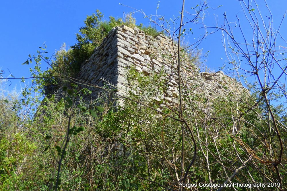
east wall of central/southern tower, Y.Kostopoulos-2019
11 / 21

north side of central/southern tower, Y.Kostopoulos-2019
12 / 21

ΝΕ corner of central/southern tower, Y.Kostopoulos-2019
13 / 21

a cistern north of the tower, Y.Kostopoulos-2019
14 / 21

top of central/southern tower with view to the south
15 / 21

north wall (and building?), Y.Kostopoulos-2019
16 / 21

north wall (and building?), Y.Kostopoulos-2019
17 / 21

north wall (and building?), Y.Kostopoulos-2019
18 / 21

east wall of central/southern tower, Y.Kostopoulos-2019
19 / 21

the “river” Velikas, Y.Kostopoulos-2019
20 / 21

east wall of central/southern tower, Y.Kostopoulos-2019
21 / 21

south wall of central/southern tower, Y.Kostopoulos-2019

THE END
| Location: |
| On a low hill 1.5 km north of the village Velika in Messinia, SW Peloponnese |
| Region > Prefecture: |  |
| Peloponnese Messenia | |
| Municipality > Town: | |
| City of Messini • Velika | |
| Altitude: | |
|
Elevation ≈ 50 m (Relative Height≈10 m) |
| Time of Construction | Origin | |
| around 1700, perhaps | VENETIAN |
|
| Castle Type | Condition | |
| Castle |
Rather Poor
|
An unstudied and unexplored castle on a low hill with thick vegetation 1.5km north of the village Velika in Messinia.
History
The hill is located at the eastern bank of the small river Velikas. The vegetation prevents the close examination of the site and the pictures in this page are taken from a long distance (except from the southern tower). No other researcher has ever approached the castle although it is mentioned by the 19th century traveler W.M.Leake as “Paliokastro” (Travels in the Morea, 1830).
The castle it is not identified with any Frankish or Venetian fortification until the 15th century. This region at the southern part of the valley of river Velikas, from the 13th to the 15th century was part of the Avramio territory which was a Venentian pocket surrounded by fiefs of the Principality of Achaea, cut from the main Venetian castles of the peninsula of Pylia, Koroni and Methoni. The Venetians had no right to build a fortification in this pocket although they might have done this after the collapse of the Principality of Achaea in 1423.
An article in a local newspaper in 2008 reveals that canon balls were found by treasure-hunters in the site. The fact that a canon was in use there, combined with the riffle holes at the walls, as seen in in the pictures, can only mean that the castle was built by the Venetians during the second Enetokratia.
The second Enetokratia during which the Venetians occupied the entire Peloponnese, lasted from 1686 until 1715. The Venetians built several inland forts during that period in anticipation of the Turkish land counterattack.
The Venetians had foreseen that it would be difficult to defend the whole of Moreas for long, but, apparently, they were hopping that they could keep some good territories like Pylia where were the cities of Koroni and Methoni which, for centuries, had been two of the most important castles of the Stato da Màr of the Serenìsima Repùblica Vèneta. Moreover, since the 16th century, there was a new stronghold there, Niokastro.
The purpose of forts like Velika and the nearby Pera was to strengthen the peripheral defense of Pylia and to secure the food supply to the main Venetian fortress-cities from the rest of Messinia.
Based on this considerations and without having more info, it is concluded that the castle of Velika was most probably built around 1700 by Venetians. The Turks who came back in 1715 did not have any use for it and soon it was deserted and forgotten.
Structure, Fortification & Buildings
The vegetation hides a large part of the fortification, which apparently extends along the entire length of the hill. Today, from a distance, we can see the ruins of a large square tower on the south side of the hill and the remains of a wall (or tower or some other building) 50 meters further north.
The original dimensions of the castle were approx. 55✖25m.
As mentioned, the only accessible point is the south tower which was probably the donjon of the castle. It was a massive tower, the original dimensions of which were 9.0✖9.5m.
Its preserved height is about 5m. The thickness of its wall is 1.60m
| First entry in Kastrologos: | May 2018 | Last update of info and text: | August 2020 | Last addition of photo/video: | August 2020 |
Sources
- Site research and photos by Giorgios Kostopoulos - 2018 and 2019
- Article by Charis Charalambopoulos, εφημερίδα ΘΑΡΡΟΣ, «Κάστρο Βελίκας-Ήταν άγνωστη η ακριβής του θέση», May 2008
- Antoine Bon, 1969, La Morée franque. Recherches historiques, topographiques et archéologiques sur la principauté d'Achaïe (1205-1430), Editions de Boccard, pp.437
- William Martin Leake, Travels in the Morea, vol I, pag 397, London 1830
- ΑΡΧΑΙΟΛΟΓΙΚΟΝ ΔΕΛΤΙΟΝ, issue 62-Β1 / 2007, page 388
- Γιάννης Μπίρης, δημοσίευμα στην εφημερίδα ΕΛΕΥΘΕΡΙΑ, Κάστρα και οχυρά της Μεσσηνίας: Τα κάστρα του ποταμού Βελίκα.
|
|
| Access |
|---|
| Entrance: |
| Free access. There is no path to the summit and the approach is practically impossible due to the vegetation. |
| Similar |
|---|
| Fort of Pera |


