

Pefkoi, Rhodes, Dodecanese,South Aegean
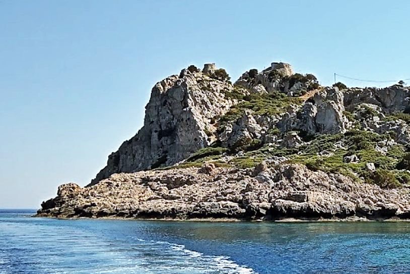
Watchtower on Cape Ginas


| Location: |
| On Cape of Ginas (or of Lindos) south of Lindos and SE of the village Pefkoi of Rhodes |
| Region > Prefecture: |  |
| South Aegean Dodecanese | |
| Municipality > Town: | |
| City of Rhodes • Pefkoi | |
| Altitude: | |
| Elevation ≈ 40 m |
| Time of Construction | Origin | |
| maybe 15th cent. | IOANNITE |
|
| Castle Type | Condition | |
| Watchtower |
Rather Poor
|
Late-medieval watchtower most probably of the Knights Hospitallers, part of the “chain” of coastal watchtowers protecting the island of Rhodes.
Castle Description
Text: Dr. Michael Losse – Singen (Hohentwiel), Germany (21.10.2021)General Description
Cape Ginas is located south of Pefkoi on the Rhodian east coast. The strikingly positioned Watchtower on the rocky Cape Ginas is also referred to in literature as [Cape] Phoka (cf. British Admiralty: Mediterranean Pilot. Vol. 4. London 1941, p. 259) and Cape Lardos (Lock 2006, p. 380: "Phoka") tower.
The tower cannot be visited because of its location in a military restricted area, and the surrounding area is also not accessible.
Most probably the Archeologist Prof. Ludwig Ross (1845, pp. 71-72) meant this tower with the following description: “The promontory of Lindos long advances into the sea. On its south side rise two protruding heights looking like old acropolises, which seem to be terraced from bottom to top. But everything is natural naked rock formation. The southern edge of the promontory runs out into a low tongue, which ends in a pointed cap, on which stands a round tower from the Knights‘ times. [...]. If you have passed the top with the round tower, this promontory splits into two arms towards the east [...].” (German original text: „Das Vorgebirge von Lindos tritt lang in die See vor. An seiner Südseite erheben sich zwei hervorstehende wie alte Akropolen aussehende Höhen, die von Unten bis Oben terrassirt zu seyn scheinen; Alles ist aber natürliche nackte Felsbildung [Küste bei Pefkoi?]. Der südliche Rand des Vorgebirges läuft in eine niedrige Zunge aus, die in ein spitzes Cap endigt, auf welchem ein runder Thurm aus den Ritterzeiten steht. […]. Wenn man die Spitze mit dem runden Thurme passirt hat, so spaltet sich dies Vorgebirge gegen Osten in zwei Arme […].”)
Access
No access: military area!
History of the tower
The tower was probably built during the Knights of St. John‘s (Hospitaller Knights‘) rule in the 15th century. Michael Heslop (2009, p. 73, note 23; plates 5-7) believes that the tower with its enceinte could have emerged from a Byzantine fortification.
Other Info
SourcesHeslop, Michael: The Search for the Byzantine Defensive System in Southern Rhodes. In: ΒΥΖΑΝΤΙΝΟΣ ΔΟΜΟΣ 16, 2007-08 [published in June 2009], pp. 69-81, here p. 73, note 23; plates 5-7.
Lock, Peter: Freestanding towers in the countryside of Rhodes. In: Elizabeth Jeffreys (Ed.): Byzantine Style, Religion and Civilization. In honour of Sir Steven Runciman. Cambridge 2006, pp. 374-393, here p. 380.
Losse, Michael: Wacht- und Wohntürme aus der Zeit des Johanniter-Ordens (1307-1522) auf der Ägäis-Insel Rhódos (Griechenland). In: Burgen und Schlösser 4, 2009, pp. 245-261.
Losse, Michael: Die Burgen und Festungen des Johanniter-Ritterordens auf Rhódos und in der Ägäis (Griechenland) 1307-1522. (Publisher: Nünnerich-Asmus Verlag) Mainz 2017.
Ross, Ludwig: Reisen auf den griechischen Inseln des ägäischen Meeres. Dritter Band. Enthaltend Melos, Kimolos, Thera, Kasos, Karpathos, Rhodos, Chalke, Syme, Kos, Kalymnos, Ios (Reisen und Länderbeschreibungen in der älteren und neuesten Zeit, eine Sammlung der interessantesten Werke über Länder- und Staaten-Kunde, Geographie und Statistik 31). Stuttgart, Tübingen 1845, pp. 71-72.
Spiteri, Stephen C.: Fortresses of the Cross. Hospitaller Military Architecture (1136-1798). Valletta (Malta) 1994, p. 153 (Entry in the overview map).
Spiteri, Stephen C.: Fortresses of the Knights. Ħamrun (Malta) 2001, p. 153 (map).
| First entry in Kastrologos: | October 2021 |
Sources
- Photo 1 from Google Maps, user Krystian Junik (June 2021)
- Article (and photo 2 -2008) by Michael Losse
|
|
| Access |
|---|
| Entrance: |
| The accessis not possible. The tower is within a base of the Greek army. |