

Myloi, Argos-Mycenae, Argolis,Peloponnese
Castle of Lerna


| Location: |
| On the hill above Myloi village of Argos area in Peloponnese |
| Region > Prefecture: |  |
| Peloponnese Argolis | |
| Municipality > Town: | |
| City of Argos-Mycenae • Myloi | |
| Altitude: | |
|
Elevation ≈ 179 m (Relative Height≈179 m) |
| Time of Construction | Origin | |
| 13th or 14th cent. | FRANKISH |
|
| Castle Type | Condition | |
| Castle |
In Ruins
|
Α Frankish castle, visible from a distance and from the sea, on a hill above the famous lake Lerna. Despite its size and its history, it remains relatively unnoticed, since the region is full of impressive and important castles (in Argos and Nafplion).
History
At the position of the modern village Myli a Frankish village existed named Chiveri or Kiveri . There is a modern village “Kiveri” but it is elsewhere, 4km to the south, on the coast.
The hill of the castle is the ancient mount Pontinos. Not especially precipitous or difficult to climb, it rises 179 m. Above the village of Myloi and the prehistoric mound of Lerna. In antiquity the summit was crowned by the Temple of Athena Saitis and the house of Hippomedon, both of which were already in ruins in Pausanias' day (Korinthiaka II, 36, 8). Today there is, besides a chapel of the Prophet Elias, only a medieval castle. As recently as 1715, the settlement at the foot of Pontinos was called Tziveri. Thus the fortress on the summit must be the medieval castle of Civeri, Kiveri, or Chamires.
The exact chronology of the medieval castle is not known, but the layout and the technology of the fortification indicate that it was most probably built by the Franks in the 13th or 14th century. It remained Frankish until 1388.
The first time that the castle is mentioned in a document is in 1347, in the will of Gautier de Brienne, Lord of Argos and Nafplion and de jure Duke of Athens.
In 1388, the last heir of the de LaRoche-de Brienne family, Marie d'Enghien, Lady of Argos, Nauplia, and Kiveri, sold the Lordship to the Duchy of Venice. But before the Proveditor, Perazzo Malipiero, could assume control, the castles of Argos , Kiveri, and Thermisi were seized by the Despot of Mystra, who did not relinquish them to the Serenissima until 1394.
Thereafter for a century and a half the Argolid was a Venetian province.
In 1458 the northeastern third of the Morea was ceded to Mehmet the, Conqueror; The new Turkish sancak was contiguous to the Argolid. In 1460, the Sultan conquered the remainder of the Greek Despotate of the Morea. Except for Monemvasia and the Venetian enclaves in Messιnia and the Argolid the whole Peloponnese now followed the Ottoman standard. In 1463 the castle of Argos was lost by treachery. Soon Kiveri (“Civeri”, as it was now called) fell into disrepair, perhaps as a result of the great Veneto-Turkish war (1463-1479); By the treaty of 1481, it was allowed to remain in Venetian hands on condition that it not be rebuilt.
Thereafter the castle of Civeri vanishes from history and there is no mention about it. It was not used during the occupation of the territory by the Ottomans (started in 1540). It was not used in the second Venetian occupation either (1688-1715).
The ruins of the castle proved useful during the Greek Revolution. The Greek general Makrygiannis, in June 1825, in the battle of Myli, chose the hill as a defending position and managed effectively to prevent the forces of Ibrahim pasha to approach Nafplion.
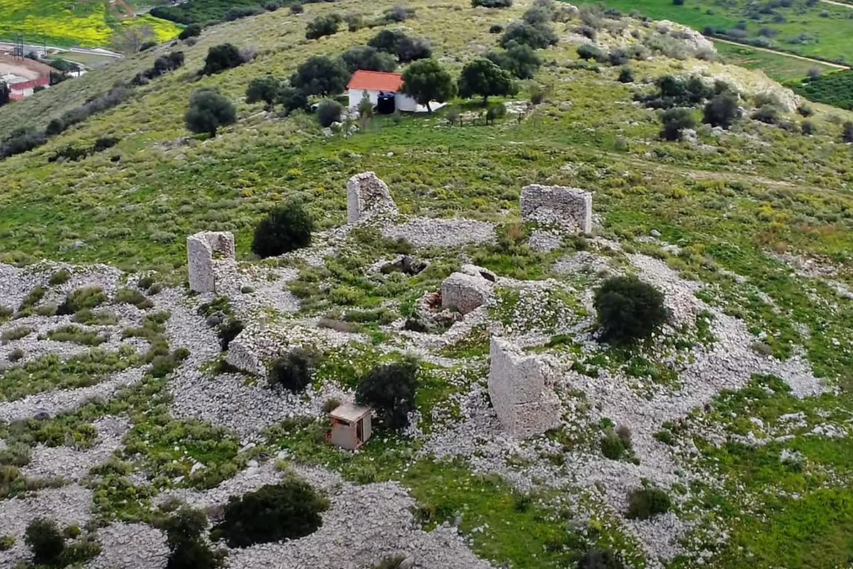
Structure, Fortification & Buildings
The castle is rather small covering and area of 9500 sq.m.
A survey of the ruins of the castle reveals three lines of defense, enclosing progressively smaller areas. The largest was an outer court, the “” or “bailey”, roughly pentagonal in shape, extending some 80 meters down the gentler north slopes of the mountain.
The bailey is outlined by a curtain wall or enceinte, about two meters thick. To the west the curtain follows a steep cliff, which in places is 6 meters high; elsewhere it acts as a retaining wall, raising the level of the court several meters above that of the exterior. Along the line of the enceinte there are seven towers. There was probably an eighth at the apex of the second salient on the west, which has completely disappeared.
The towers are, for the most part, rectangular, from 2.60 m. to 4.60 m. in width; they project 2.5 m. to 3.0 m. from the wall. The interval between them varies from less than 25 m. to 45 m. The towers are not bonded with the curtain. One tower (the southwest) has a single face with a batter; elsewhere the walls are vertical.
The bailey is filled with the foundations of numerous small buildings. Towards the northeast, against the curtain, is a small apsidal church. These structures presumably date from the period when the fort was in use. The summit of the hill was fortified with an inner court, the " redoubt ", hexagonal with towers at the salients. The diameter of the court is about 30 m.
The curtain (again two meters thick) has collapsed; its line is marked by a ridge of debris a meter higher than the ground level. The gate may have been between the south and southwest towers the route by which the modern path enters. No indication was found of a gate between bailey and redoubt.
The towers, which are twenty meters apart, are not bonded with the adjoining curtain. They vary in size, shape, and to some extent in building technique. The two on the east are rectangular, the others quadrangular but asymmetrical.
None of the towers is preserved to full height. The two best-preserved are the termini of the bailey enceinte; both are hollow.
The most notable edifice still visible in the redoubt is a cistern, doubly vaulted with a transverse arch; its floor is below ground level. It is surrounded on three sides by piles of fallen rubble, in which one can trace the outer faces of massive walls. This is all that remains of the keep or donjon. In Buchon's time more survived; he describes it as a square tower, several storeys high. It was nine meters square, with walls about 1.35 m. thick. The cistern was in the southeast corner.
Within the redoubt there are also foundations of several isolated walls, as well as a second cistern, similar to the preceding.
The whole fortress is built of the gray limestone of Pontinos. The walls are constructed of roughly coursed field stones; in some of the towers the interstices between the stones are filled with tile fragments. Some corners (particularly of the redoubt) are reinforced by the use of larger stones. The mortar employed has in general deteriorated until it has become like earth or sand; it has however remained quite hard and cement-like in the two cisterns and in four of the redoubt towers (northwest, northeast, southeast, and south).
A comparison of the ruins of Kiveri with those of other mediaeval fortifications in Greece reveals a few datable characteristics: The square keep is typically Frankish. The hexagonal redoubt is associated with the Crusaders. The tripartite division into keep, redoubt, and ward is usually Frankish, although it may have been employed on occasion by the Byzantines.
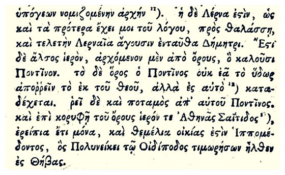
Collateral stories
The text about Pontinos from Pavsanias
| First entry in Kastrologos: | October 2012 | Last addition of photo/video: | May 2023 |
Sources
- Wallace E. McLeod, Hesperia: The Journal of the American School of Classical Studies at Athens, Volume 31, Issue 4, “KIVERI AND THERMISI”, 1962
- Ι.Ε. Πέππας, Μεσαιωνικές σελίδες της Αργολίδας, Αρκαδίας, Κορινθίας, Αττικής, Αθήνα 1990, σελ. 164-166
- Video by the user haanity 480 Έλληνες κατατροπώνουν 6.200 Τούρκους: Το πεδίο της Μάχης των Μύλων (1825) (2018), photos 7, 8, 9, 11
- Video by the user G Traveller Κάστρο Κιβερίου | Castle of Kiveri (April 2023), source of photos 1, 2, 3, 5
|
|
| Access |
|---|
| Approach to the monument: |
| - |
| Entrance: |
| Free access |


