

Mandraki, Hydra, Piraeus & Islands,Attica
Forts of Mandraki in Hydra


| Location: |
| Mandraki in Hydra island, at the two capes of the bay |
| Region > Prefecture: |  |
| Attica Piraeus & Islands | |
| Municipality > Town: | |
| City of Hydra • Mandraki | |
| Altitude: | |
| Elevation ≈ 7 m |
| Time of Construction | Origin | |
| late 16th century | VENETIAN |
|
| Castle Type | Condition | |
| Coastal Fortress |
Not Good
|
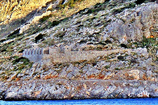
Mandraki was the naval station of Hydra during the Venetian occupation (16th to 18th century).
There were two small forts protecting the entrance of the bay. (Both are presented in this page.)
They were built around the end of the 16th century.
They have been reinforced during the Greek revolution and renovated recently, in 2008-2009.
| First entry in Kastrologos: | January 2014 |
|
|
| Access |
|---|
| Approach to the monument: |
| The fort is around 10 minutes on foot from the hotel Miramare, in Mandraki bay of Hydra |
| Entrance: |
| Free access |
| Other castles around |
|---|
| Fort of Aderes |
| Monastery of Agios Athanasios |
| Castle of Damalas |
| Castle of Dokos |
| Castle of Favieros |
| Castle of Kokkinia |
| Burtzi of Poros |
| Thermisi |
| Castle of Tselevinia |