

Strongyli (isl.), Istiaia-Aidipsos, Euboea,Central Greece
Fortification of Strongyli


| Location: |
| On the islet Strongyli at the northern opening of the Euboean gulf, offshore Kamena Vourla |
| Region > Prefecture: |  |
| Central Greece Euboea | |
| Municipality > Town: | |
| City of Istiaia-Aidipsos • Strongyli (isl.) | |
| Altitude: | |
|
Elevation ≈ 8 m (Relative Height≈0 m) |
| Time of Construction | Origin | |
| 12th-15th cent. | BYZANTINE |
|
| Castle Type | Condition | |
| Castle-Monastery |
In Ruins
|
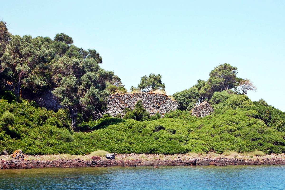
Remains of a strong fortification of a monastic dependency (metochi) on the uninhabited islet of Strongyli in the northern Euboean gulf, across from Kammena Vourla, very close to the Euboea cape of Kavos (the ancient Kenaion).
The metochi belonged to the Monastery of Metamorfosis Sotiros (Transfiguration of Jesus), which is located 4 kilometers above Kammena Vourla, at an altitude of 310 meters. This monastery dates from the 11th or 12th century.
Strongyli is a small islet that belongs to the complex of the so-called “Lihadonisia”. According to Strabo, Lichadonisia were formed from the dismembered corpse of Lichas, a servant of Heracles. Lichas was the one who supposedly gave Heracles to wear the poisoned tunic, and he, in a frenzy, threw him into the sea from Cenaion.
History
The first reference to the metochi of Strongyli is found in a patriarchal sigillum of 1621 signed by the Patriarch of Constantinople Kyrillos Lukaris. The sigillum mentions 6 dependencies of the monastery, one of which is the "metochi of Panagia" on the islet of Strongyli.
The islet is also known as the place where the monk Saint Gregory the Spartan lived and buried. He must have lived in more or less the same era as Saint Nikitas, founder of the Monastery of the Transfiguration, who we know lived in the 11th century.
According to the above indications, the metochi was active from the end of the 11th century to the beginning of the 17th century, at least. However, the fact that only a few traces of ecclesiastical buildings remain, leads to the hypothesis that the metochi has been abandoned for many centuries. It is possible that, even at the time of the sigillum, it was already deserted.
Another consideration is the strong and extensive fortification that shows that at some time (perhaps in the late Middle Ages, during the Frankokratia) the metochi was rich and populated.
The dating of the fortification of Strongyli cannot be precise. It was certainly completed after the 11th century (the time when the monastery was founded and Saint Gregory was installed on the islet). And it certainly could not have been built during the Tourkokratia.
Apart from the use of the islet as a monastic place, it should be noted that the islet is in a strategic position, at the entrance from the north of the once-busy Euboean gulf, right on the junction of the Orea channel with the Knimida channel. The point could control the sea traffic from Euboea and East Central Greece to the Aegean and Pagasitikos. Which means that this excessive for metochi fortification may have had primarily a military fort.
This point is not very enlightening because it further complicates the history of the fortification. It could, for example, have existed since the mid-Byzantine period and was abandoned before the island became a monastery.
Anyway, we do not know exactly when the fortification was built. Our best guess is that it was built somewhere between the 12th and 15th centuries.
Structure, Fortification & Buildings
The ruins of the metochi of Panagia are preserved on the north side of the island, next to the newer chapel of Agios Nikolaos. The metochi had a fortification that initially protected the perimeter of the entire islet. Today, a section of about 100 meters on the north-east side is preserved at a considerable height (see layout). Other fragments of the wall can be seen on the rest of the island, at a low height in dense vegetation.
The maximum preserved height of the wall is 4 meters and the thickness 1.70 meters. The gate is located on the northwest side. On the wall of the NE side there is a square tower.
The masonry consists of semi-finished stones of medium size fitted with stones of smaller size. The binding material is plaster. There are ceramics in the joints, but not much.
On the surface of the wall there are 15✖5 cm holes that were used to mount the scaffolding during the erection of the wall.
In the interior of the island, amidst dense vegetation, the ruins of the church of the metochi can be seen, which was probably the burial place of Saint Gregory. The church is rectangular with dimensions of 9.60✖6.75 m. It belongs to the semi-inscribed cross type. At least 3 phases of construction and use from at least the 12th century onwards can be observed.
At a short distance from the church there are few ruins of other buildings of undetermined date and use.
| First entry in Kastrologos: | July 2022 |
Sources
- Άννα Γιαλούρη, Πέτρος Κουνούκλας, «Το μετόχι της μονής Μεταμορφώσεως του Σωτήρος στη νήσο Στρογγυλή στο Βόρειο Ευβοϊκό κόλπο», ΑΡΧΑΙΟΛΟΓΙΚΟ ΕΡΓΟ ΘΕΣΣΑΛΙΑΣ (Πρακτικά επιστημονικής συνάντησης), Βόλος, 2006, σελ.1185-1197
|
|
| Access |
|---|
| Approach to the monument: |
| Approached only by boat from Kamen Vourla or North Euboea |
| Entrance: |
| Free acces |
| Other castles around |
|---|
| Acropolis of Achinos |
| Tower of Atalanti |
| Palaiopyrgos of Atalanti |
| Tower of Lichada |
| Castle of Mendenitsa |
| Monastery of Profitis Elias |


